Chunchucmil
| Chunchucmil | |
|---|---|
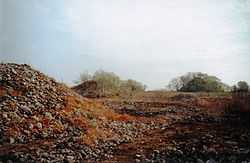 Archaeological mounds of ancient Chunchucmil. | |
 Chunchucmil | |
| Location | |
| Coordinates | 20°38′18.82″N 90°11′24.79″W / 20.6385611°N 90.1902194°W |
| Country |
|
| Region | Yucatán |
Chunchucmil was once a large, sprawling pre-Columbian Maya city located in the western part of what is now the state of Yucatán, Mexico.
Although the famous explorer and author John Lloyd Stephens traveled within a few kilometers of Chunchucmil during his historic journey across the Yucatán Peninsula (he even met with the owner of the nearby Haciendas),[1] the archaeological site went relatively unnoticed by Maya scholars for more than a century because virtually no monuments (stelae) or other grand sculptures have been found there. The lack of royal monuments, combined with other archaeological data (see below), may indicate that Chunchucmil was not a city ruled by a single divine king, as most other Maya polities. Instead, it may have been a commercial center, organized by various lineages and focused upon funneling goods between regions—such as the trade between the Gulf of Mexico and the interior of the Yucatán Peninsula.
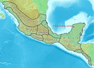 Map of Mesoamerica highlighting the location of Chunchucmil | |
| Country: | Mexico |
|---|---|
| State: | Yucatán |
| Municipality: | Maxcanú |
| Culture: | Maya |
| Peak of Occupation: | Early Classic Period |
| Chronological Range of Occupation: | Middle Preclassic - Terminal Classic |
| Estimated Size: | 25 – 65 km² |
| Estimated Peak Population: | 31,000 - 43,000 (within the central 25 km² area) |
Site characteristics
Location
Environment and ecology

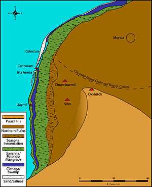
However, the ancient city was situated at the edge of this semi-arid ecological zone, exactly where the dry Yucatecan plains dip and fracture into vast wetlands (see map). Immediately to the west of Chunchucmil are found the seasonally inundated savannas, fresh water petenes (or ojos de agua), and eventually the brackish mangrove estuary where the Yucatán aquifer empties into the Gulf of Mexico near the ancient Maya coastal site of Canbalam. It is likely that ancient Chunchucmil was purposefully situated to take advantage of multiple ecological zones, including coastal resources such as the salt-beds of the Celestún peninsula, and to increase accessibility to the vigorous circum-peninsular canoe trade route of Pre-Columbian times, using Canbalam as its port of entry.[7]
Etymology
The term "Chunchucmil" was originally used to name a freshwater well (Ch'en Chun Chukum), the central water source for the cattle ranch that eventually grew to become the historic henequen hacienda of Chunchucmil. Most wells in this region are named after animals or plants. In this case, the words Ch'en Chun Chukum literally mean "the well at the base of the Chukum tree" (Havardia albicans). Local Maya speakers still refer to the modern village of Chunchucmil as Chun Chukum when speaking in their native tongue. The ancient Maya archaeological site was given the name Chunchucmil by archaeologists in the 1970s because that was the closest modern community to the site center.[8] Local Maya villagers today do not have a single term to refer to the ruins, since the ancient city is so large that it encompasses most of their lands.
Site size

Chronology
Ceramic data indicate that the Chunchucmil region was occupied from the Middle Preclassic (Middle Formative) through the Postclassic periods of Maya prehistory. However, widespread test excavations within the architectural groups of ancient Chunchucmil indicate that the city reached its apogee during the latter part of the Early Classic and the early part of the Late Classic, attaining its maximum spatial extent, population, and structural density. This period is defined in some areas as the "Middle Classic."[10] Chunchucmil appears to have gone into decline during the latter part of the Late Classic. The Terminal Classic (or Puuc) occupation at Chunchucmil is ephemeral at best, and the Postclassic occupation at the site consisted of squatter-like settlement. A few early colonial homesteads have been found, but the region was largely abandoned between the Maya Postclassic period and the beginnings of the cattle ranches and henequen haciendas of historic and modern times.
Built environment
Monumental architecture

Residential architecture
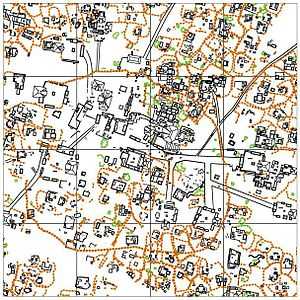
Residential architecture at Chunchucmil often follows the same pattern as the large quadrangle groups, with structures arranged on four sides of a small plaza. This arrangement conforms to the "patio cluster" or "patio group" model for Maya residential organization, where two or more structures, potentially housing multiple family units, face a shared patio or courtyard.[13][14]

Many residential groups had a small temple or shrine (similar to the placement of the temple pyramids of their larger counterparts). These buildings served as loci for the performance of household rituals or other types of ideological practices.[18] One such residential shrine that has been excavated and consolidated at the Lool Group revealed its form to be talud-tablero. This style of architecture is most famous at sites in Central Mexico, such as at the contemporaneous city of Teotihuacan. Beneath the stair of this shrine was a vessel that also replicated the pottery of that Central Mexican city. While this should not be used as evidence of direct Teotihuacan influence, it does suggest Chunchucmil's participation in the greater Mesoamerican communication sphere at the time of Teotihuacan's dominance. It should also be noted that all other structures excavated at Chunchucmil thus far lack demonstrable Teotihuacan influence.
Transportation arteries
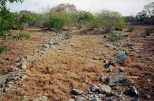
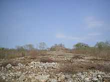
Beyond Chunchucmil, in the seasonally inundated western wetlands, researchers have found a network of rock alignments that connect Chunchucmil's periphery to other outlying settlements. Such rock alignments, called andadores by Maya archaeologists, would have provided sure footing through the wetlands, like stepping stones, leading travelers to various towns and resources in Chunchucmil's hinterland. While not all of these andadores have been followed to their final destinations, the general orientation of the longest alignments suggest that they may have functioned to connect Chunchucmil with the coast near Canbalam.[19]
Barricade and abandonment
One of the first features of Chunchucmil to gain widespread attention was a stone wall, visible in aerial photos taken by the Atlas project,[20] that roughly encircles 350,000 square metres of the site center (including most of the major Quadrangle Groups).[21] Early reconnaissance by the Pakbeh Regional Economy Project in the late 1990s found that the wall, which stood between 1 and 1.5 m tall and had a perimeter of 1.8 km, was incomplete. It formed a large "C" shape with a 340 m wide gap open to the west (see map). Further mapping and excavation revealed that the wall runs above every major feature at the ancient site (crossing sacbeob', albarradas, and many residential groups). Based upon the law of superposition (an archaeological concept borrowed from the field of geology), this meant that the large barricade was likely the last feature to be built at the site. Furthermore, the stones used to create the barricade were clearly robbed from nearby structures (rather than freshly quarried). Given this data, it has been hypothesized that the barricade was constructed rapidly at the end of Chunchucmil's history, possibly to protect the remaining inhabitants from an invasion that arrived before the wall could be completed,[22] leading to the ultimate demise of the ancient city.
Economy and diet
Lithic economy

The exploitation of non-obsidian stone resources (e.g., chert, chalcedony, and quartz) did occur at Chunchucmil, but these materials are much less common than obsidian. The majority of these resources, especially chert, were obtained locally from nodules in the limestone bedrock, but were very poor in quality. While a number of formal tools were produced from chert and quartz, most non-obsidian tools were informal and produced through expedient flake production.
The fact that obsidian was favored over local resources for utilitarian tools is interesting, especially considering that obsidian had to be imported over long distances. The El Chayal obsidian source (which is the most common at Chunchucmil), is located nearly 1000 km (621 mi) away (as the crow flies) in Guatemala. This, once again, indicates Chunchucmil's close ties with external trade routes and the greater Mesoamerican world of the Classic period.
Market system

Subsistence
As mentioned above, one important question concerning ancient Chunchucmil is how such a large population could have survived in one of the poorest areas for agriculture. According to bone isotope studies conducted by Pakbeh Regional Economy Project member Geni Mansell,[28] the diet of the ancient inhabitants may have been more diversified than in other areas of the Maya region. When compared with skeletal remains from other parts of Yucatán, Belize and the southern Maya lowlands, human remains from Chunchucmil indicate that their diet included significantly less corn (maize, the staple crop for most communities in the Maya area). Access to the more ecologically diverse wetlands and coastal resources, as well as access to inter-regional trade routes and a centralized marketplace, may have been critical to ancient subsistence at Chunchucmil.[29]
See also
- Maya architecture
- List of Maya Sites
Notes
- ↑ Stephens 1962 (1842).
- ↑ Luzzadder-Beach 2000.
- ↑ Dahlin et al. 1996.
- ↑ Beach 1998.
- ↑ Vlcek et al. 1978.
- ↑ Farrell et al. 1996.
- ↑ Dahlin et al. 1998.
- ↑ Garza & Kurjack 1980.
- ↑ Hixson 2005.
- ↑ Varela 1990; see also Ardren 2000; Stanton 2000; Dahlin & Mazeau 2002, 2004, and Hutson et al. 2005, 2006.
- ↑ Dahlin & Ardren 2002.
- ↑ Sharer & Traxler 2006:581.
- ↑ Ashmore 1981
- ↑ Wilk 1988:143
- ↑ Vlcek 1978.
- ↑ Hutson et al. 2004.
- ↑ Hutson et al. 2006.
- ↑ Magnoni et al. 2004.
- ↑ see report chapters by Hixson in Ardren 2000; Stanton 2000; Dahlin & Mazeau 2002, 2004; and Hutson et al. 2005, 2006.
- ↑ Garza & Kurjack 1980.
- ↑ Kurjack & Andrews 1976.
- ↑ Dahlin 2000.
- ↑ Clark 1997.
- ↑ Clark & Bryant 1997.
- ↑ Dahlin et al. 2005.
- ↑ Hirth 1998.
- ↑ Dahlin 2003.
- ↑ Mansell et al. 2006.
- ↑ see also, Dahlin et al. 2005.
References
- Ardren, Traci (editor) (2000) The Chunchucmil Regional Economy Project: Report of the 1999 Field Season. Department of Anthropology, Florida State University, Tallahassee
- Ashmore, Wendy (1981) Some Issues of Method and Theory in Lowland Maya Settlement Archaeology. In Lowland Maya Settlement Patterns, edited by W. Ashmore, pp. 37-70. University of New Mexico Press, Albuquerque.
- Beach, Tim (1998) Soil Constraints on Northwest Yucatán: Pedoarchaeology and Subsistence at Chunchucmil. Geoarchaeology 13(8):759-791.
- Clark, John E. (1997) Prismatic blademaking, craftsmanship, and production: an analysis of obsidian refuse from Ojo de Agua, Chiapas, Mexico. Ancient Mesoamerica 8:137-159.
- Clark, John E., and Douglas D. Bryant (1997) Technological typology of prismatic blades and debitage from Ojo de Agua, Chiapas, Mexico. Ancient Mesoamerica 8: 111-136.
- Dahlin, Bruce H. (2000) The Barricade and Abandonment of Chunchucmil: Implications for Northern Maya Warfare. Latin American Antiquity 11(3):283-298.
- —— (2003) Chunchucmil: A Complex Economy in NW Yucatán. Mexicon XXV:129-138.
- Dahlin, Bruce H. , Anthony P. Andrews, Tim Beach, Clara Bezanilla, Patrice Farrell, Sheryl Luzzadder-Beach, and Valerie McCormick (1998) Punta Canbalam in Context: A Peripatetic Coastal Site in Northwest Campeche, Mexico. Ancient Mesoamerica 9(1):1-16.
- Dahlin, Bruce H. and Traci Ardren (2002) Modes of Exchange and Their Effects On Regional and Urban Patterns at Chunchucmil, Yucatán, Mexico. In Ancient Maya Political Economies, edited by M. A. Masson and D. Freidel, pp. 249-284. Altamira Press, Walnut Creek CA.
- Dahlin, Bruce H., Timothy Beach, Sheryl Luzzadder-Beach, David R. Hixson, Scott R. Hutson, Aline Magnoni, Eugenia B. Mansell, and Daniel E. Mazeau (2005) Reconstructing Agricultural Self-Sufficiency at Chunchucmil, Yucatán, Mexico. Ancient Mesoamerica 16(2):1-19.
- Dahlin, Bruce H., B. Leyden, M. Brenner, J. Curtis, D. Piperno, and T. Whitmore (1996) A Record of Long and Short-Term Climatic Variation from Northwest Yucatán: Cenote San Jose Chulchaca. In The Managed Mosaic: Ancient Maya Agriculture and Resource Use, edited by S.. Fedick. University of Utah Press, Salt Lake City.
- Dahlin, Bruce H., and Daniel E. Mazeau (editors) (2002) The Pakbeh Regional Economy Program: Report of the 2001 Field Season. Department of Sociology/Anthropology, Howard University, Washington D.C.
- —— (2004) The Pakbeh Regional Economy Program: Report of the 2002 Field Season. Department of Sociology/Anthropology, Howard University, Washington D.C.
- Farrell, Patrice, Timothy Beach, and Bruce H. Dahlin (1996) Under the Roots of the Chukum Tree: A Preliminary Soil Analysis of the Chunchucmil Region, Yucatán/Campeche, Mexico. Yearbook, Conference of Latin American Geographers 22:41-50.
- Garza Tarazona de Gonzalez, Silvia, and Edward B. Kurjack (1980) Atlas Arqueoiogico del Estado de Yucatán. 2 vols. Instituto Nacional de Antropologia e Historia, Gentro Regional del Sureste. Mexico D.F.
- Hirth, Kenneth G. (1998) The Distributional Approach: A New Way to Identify Marketplace Exchange in the Archaeological Record. Current Anthropology 39: 451-476.
- Hixson, David R. (2005) Measuring a Maya Metropolis. Institute of Maya Studies Newsletter 34(1):1-4.
- Hutson, Scott R., David R. Hixson, and Bruce H. Dahlin (editors) (2005) The Pakbeh Regional Economy Program: Report of the 2004 Field Season.
- —— (2006) The Pakbeh Regional Economy Program: Report of the 2005 Field Season.
- Hutson, Scott R., Aline Magnoni, Daniel E. Mazeau and Travis W. Stanton (2006) The Archaeology of Urban Houselots at Chunchucmil, Yucatán, Mexico. In Lifeways in the Northern Lowlands: New Approaches to Maya Archaeology, edited by J. P. Mathews and B. A. Morrison pp. 77-92. University of Arizona Press., Tucson.
- Hutson, Scott R., Aline Magnoni and Travis Stanton (2004) House Rules?: the Practice of Social Organization in Classic Period Chunchucmil, Yucatán, Mexico. Ancient Mesoamerica 15:74-92.
- Kurjack, Edward B. and E. Wyllys Andrews V (1976) Early Boundary Maintenance in Northwest Yucatán, Mexico. American Antiquity 41:318-325.
- Luzzadder-Beach, Sheryl (2000) Water Resources of the Chunchucmil Maya. The Geographical Review 90(4):493-510.
- Magnoni, Aline, Scott R. Hutson, Eugenia Mansell, and Travis W. Stanton (2004) La Vida Doméstica Durante el Periodo Clásico en Chunchucmil, Yucatán. In XVII Simposio de Investigaciones Arqueológicas en Guatemala, 2003, edited by J. P. Laporte, H. Escobedo, and B. Arroyo, pp. 991-1006. Museo Nacional de Arqueología y Etnología, Guatemala.
- Mansell, Eugenia B., Robert H. Tykot, David Freidel, Bruce H. Dahlin, and Traci Ardren (2006) Early to Terminal Classic Diet in the Northern Maya Lowlands. In Histories of Maize, Academic Press.
- Sharer, Robert J. and Loa P. Traxler (2006) The Ancient Maya (6th Ed.). Stanford University Press, Stanford.
- Stanton, Travis W. (editor) (2000) The Pakbeh Regional Economy Program: Report of the 2000 Field Season. Social Science and Business Division, Jamestown Community College, Jamestown, NY
- Stephens, John L. (1962 [1843]) Incidents of Travel in Yucatán (2 vol.). University of Oklahoma Press, Norman.
- Vlcek, D. T. (1978) Muros de Delimitacion Residencial en Chunchucmil. Boletin de la Escuela de Ciencias, Antropologicas de la Universidad de Yucatán 28:55-64.
- Vlcek, D. T., Silvia Garza de Gonzalez, and Edward B. Kurjack (1978) Contemporary Farming and Ancient Maya Settlements: Some Disconcerting Evidence. In Pre-Hispanic Maya Agriculture, edited by P. D. Harrison and B. L. Turner II, pp. 211-223. University of New Mexico Press, Albuquerque.
- Wilk, Richard R. (1988) Maya Household Organization: Evidence and Analogies. In Household and Community in the Mesoamerican Past, edited by W. Ashmore, pp. 135-151. University of New Mexico Press, Albuquerque.
- Varela Torrecilla, Carmen (1990) Un nuevo complejo en la secuencia cerámica de Oxkintok: El Clásico Medio. Oxkintok 3:113-126. Madrid
External links
- Prehistory of Chunchucmil A summary of the prehistory of ancient Chunchucmil, also containing a link to the modern history of Hacienda Chunchucmil. These summaries were created to assist volunteers who provided free medical, dental, and construction services to the modern village in 2002.
- Digital reconstruction of Chunchucmil Digital reconstructions of one neighborhood within Chunchucmil using the "Unreal Runtime" 3D engine.
- Mayaquest visit Brief notes by the "Mayaquest" team as they visited Chunchucmil in their tour of the Maya region.
Coordinates: 20°38′19″N 90°11′25″W / 20.63856°N 90.19022°W
