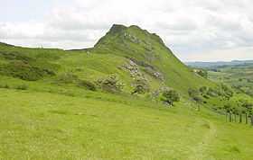
Chrome Hill
| Chrome Hill | |
|---|---|
 | |
| Elevation | c. 425 m (c. 1394 ft) |
| Location | |
| Location | Peak District, England |
| OS grid | SK070673 |
| Topo map | OS Landranger 119 |
Chrome Hill /ˈkruːm/ is a limestone reef knoll[1] on the Derbyshire side of the upper Dove valley. It is adjacent to the more distinctive but lower Parkhouse Hill.
Chrome Hill was declared open access land[2] under the provisions of the Countryside and Rights of Way Act 2000. However, the only access from the North West remains along a concessionary footpath. Chrome Hill contains good exposures of Gigantoproductus fossils; it is part of a designated Site of Special Scientific Interest[3] and visitors are asked not to remove geological samples.
In 1997, the writer Jeff Kent discovered that a double sunset could be seen against Chrome Hill from the southern flank of Parkhouse Hill. Two years later, the author discovered that a similar event took place from nearby Glutton Bridge, on the upper valley of the River Dove, which was more easily accessible. Shortly afterwards, the phenomenon was first captured on film by the photographer Chris Doherty.[4] Since 2002, Kent has offered guided public viewings of the occurrence from Glutton Bridge on the summer solstice and the night either side, with a fair degree of success.[5] The phenomenon is visible from Glutton Bridge in good weather for a short period around the summer solstice, when the sun sets just to the southwest of the summit of Chrome Hill, begins to re-emerge almost immediately afterwards from its steep northeastern slope before fully reappearing and later sets for a second and final time at the foot of the hill. The precise event and its location are described in Kent's book The Mysterious Double Sunset.[6]
Chrome Hill has had songs written in its honour by the Norwegian musicians Sigurd Hole (Chrome Hill[7]) and Jonas Howden Sjøvaag (Up on Chrome Hill[8]). In 2008 the Norwegian jazz quartet Damp changed its name to Chrome Hill.
Coordinates: 53°12′10″N 1°53′48″W / 53.20273°N 1.89666°W
References
- ↑ Wolverson Cope, F. (1999). The Peak District. Geologist' Association Guide No. 26 (3rd revised edition ed.). The Geologists' Association. ISBN 0-900717-11-4.
- ↑ Townroe, P.M. (2003). Appeal Decision. The Planning Inspectorate. CROW/2/M/03/735.
- ↑ "SSSI Citation". Natural England. Retrieved 5 January 2010.
- ↑ The Mysterious Double Sunset, pages 102, 110, 111 and 113-114, Jeff Kent, ISBN 0-9529152-5-1, Witan Books, 2001.
- ↑ Various editions of Buxton Advertiser, Leek Post & Times, and The Sentinel, 2002-2012.
- ↑ The Mysterious Double Sunset, especially photographs 23 (i)-(iv) and page 200, Jeff Kent, ISBN 0-9529152-5-1, Witan Books, 2001.
- ↑ Eple Trio (2007). Made This. NORCD. Catalog NORCD0766.
- ↑ Navyelectre (2008). The Mourning. Shipwreckords. ASIN B000YB6VG2.
| ||||||||||||||
