Chippewa River (Minnesota)

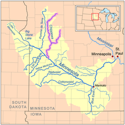
The Chippewa River is a 153-mile-long (246 km)[1] tributary of the Minnesota River in western and southwestern Minnesota in the United States. Via the Minnesota River, it is part of the watershed of the Mississippi River.
Course
The Chippewa River issues from Stowe Lake in Douglas County, 3 miles (5 km) northwest of Brandon, at the west end of a series of lakes that extends northward to lakes Aaron and Moses and eastward to Chippewa Lake. The Chippewa River passes through several more lakes in its upper course. It initially flows westwardly into Grant County, where it turns generally southward for the remainder of its course through Pope, Stevens, Swift and Chippewa counties. The river passes the towns of Hoffman, Cyrus and Benson; it joins the Minnesota River in Montevideo. Some sections of the river, especially along its middle course in Pope and Swift Counties, have been straightened and channelized.
In Pope County, the river collects the Little Chippewa River, 41 miles (66 km) long, which flows generally southwestwardly through Douglas and Pope counties. At Benson it collects the East Branch Chippewa River, about 64 miles (103 km) long,[1] which rises in southeastern Douglas County and flows initially southward through Pope County, passing through several lakes, into Swift County, where it turns westward.
See also
Coordinates: 44°56′05″N 95°44′00″W / 44.9346792°N 95.7333596°W[2]
References
- ↑ 1.0 1.1 U.S. Geological Survey. National Hydrography Dataset high-resolution flowline data. The National Map, accessed October 5, 2012
- ↑ U.S. Geological Survey Geographic Names Information System: Chippewa River
- Columbia Gazetteer of North America entry
- DeLorme (1994). Minnesota Atlas & Gazetteer. Yarmouth, Maine: DeLorme. ISBN 0-89933-222-6.
- Geographic Names Information System entries for U.S. Geological Survey Geographic Names Information System: Chippewa River, U.S. Geological Survey Geographic Names Information System: East Branch Chippewa River, U.S. Geological Survey Geographic Names Information System: Little Chippewa River