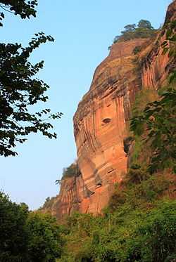
China Danxia
From Wikipedia, the free encyclopedia
| China Danxia | |
|---|---|
| Name as inscribed on the World Heritage List | |
 | |
| Type | Natural |
| Criteria | vii, viii |
| Reference | 1335 |
| UNESCO region | Asia-Pacific |
| Inscription history | |
| Inscription | 2010 (34th Session) |
China Danxia, or Danxia landform of China, is the general name of the unique type of landscapes, Danxia landform, formed from red sandstone and characterised by steep cliffs,[1] which are caused by endogenous forces (including uplift) and exogenous forces (including weathering and erosion).[2]
In August 2010, China Danxia was inscribed onto the World Heritage List.[3]
| Serial ID Number | Name & Location | Coordinates | Area |
|---|---|---|---|
| 1335-001 | Chishui - West Section | 28°22′11″N 105°47′39″E / 28.36972°N 105.79417°E | Property: 10142 Ha
Buffer zone: Ha |
| 1335-002 | Chishui - East Section | 28°25′19″N 106°02′33″E / 28.42194°N 106.04250°E | Property: 17222 Ha
Buffer zone: Ha |
| 1335-003 | Taining - North Section | 27°00′37″N 117°13′07″E / 27.01028°N 117.21861°E | Property: 5277 Ha
Buffer zone: Ha |
| 1335-004 | Taining -South Section | 26°51′56″N 117°02′22″E / 26.86556°N 117.03944°E | Property: 5810 Ha
Buffer zone: Ha |
| 1335-005 | Langshan | 26°20′24″N 110°46′45″E / 26.34000°N 110.77917°E | Property: 6600 Ha
Buffer zone: 6200 Ha |
| 1335-006 | Danxiashan | 24°57′55″N 113°42′12″E / 24.96528°N 113.70333°E | Property: 16800 Ha
Buffer zone: 12400 Ha |
| 1335-007 | Longhushan: Longhushan Section | 28°04′15″N 116°59′05″E / 28.07083°N 116.98472°E | Property: 16950 Ha
Buffer zone: Ha |
| 1335-008 | Longhushan: Guifeng Section | 28°19′03″N 117°25′10″E / 28.31750°N 117.41944°E | Property: 2740 Ha
Buffer zone: Ha |
| 1335-009 | Jianglangshan | 28°22′11″N 105°47′39″E / 28.36972°N 105.79417°E | Property: 610 Ha
Buffer zone: 571 Ha |
See also
References
External links
This article is issued from Wikipedia. The text is available under the Creative Commons Attribution/Share Alike; additional terms may apply for the media files.