Chemin-A-Haut State Park
| Chemin-A-Haut State Park | |
|---|---|
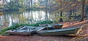
 Boats on the water in Chemin-A-Haut State Park. | |
 | |
| Location | Morehouse Parish, Louisiana, United States of America |
| Coordinates | 32°54′36″N 91°50′42″W / 32.91°N 91.845°WCoordinates: 32°54′36″N 91°50′42″W / 32.91°N 91.845°W[1] |
| Area | 503 acres (2.04 km2; 0.786 sq mi)[1] |
| Established | 1935[2] |
| Governing body | Louisiana Office of State Parks |
| Official website | |
Chemin-A-Haut State Park is a 503-acre (2.04 km2) site located in northern Morehouse Parish, Louisiana. Visitors may access the park from U.S. Highway 425 about 10 miles (16 km) north of Bastrop. Chemin-à-Haut means "High Road" in French. Much of the park is on a high bluff overlooking winding Bayou Bartholomew. Chemin-A-Haut was one of the earliest additions to the Louisiana State Park system.
The Nature Conservancy in Louisiana has recently acquired the 247-acre (1.00 km2) DeBlieux tract, located in a large bend of Bayou Bartholomew, and will eventually transfer the land to the State of Louisiana. The property will be added to Chemin-A-Haut, thus increasing the park's size to 750 acres (3.0 km2).[3] Bayou Bartholomew contains over 115 fish species, one of the highest counts of any stream in North America.
Visitors to Chemin-A-Haut State Park may enjoy Camping, Fishing, Hiking, Picnicking and Wildlife Observation. There is a 8-mile (13 km) Equestrian Trail for Horseback riders. During the hot Summer months, guests may cool off in an on-site swimming pool.
References
- ↑ 1.0 1.1 "Chemin-A-Haut State Park - Louisiana Office of State Parks". Retrieved 30 January 2011.
- ↑ 2009 Wall Calendar - 75 Years of Celebrating Louisiana's Treasures and Making Memories. Louisiana State Parks. 2009.
- ↑ "The Nature Conservancy in Louisiana - TNC Acquires Property Adjacent to Bayou Bartholomew to Expand Chemin-A-Haut State Park".
External links
| |||||||||||||||||||||||||||||||||||||||||||||||