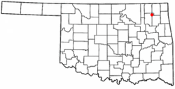
Chelsea, Oklahoma
| Chelsea, Oklahoma | |
|---|---|
| Town | |
 | |
| Coordinates: 36°32′8″N 95°25′53″W / 36.53556°N 95.43139°WCoordinates: 36°32′8″N 95°25′53″W / 36.53556°N 95.43139°W | |
| Country | United States |
| State | Oklahoma |
| County | Rogers |
| Government | |
| • Mayor | Daryl Price |
| Area | |
| • Total | 1.7 sq mi (4.4 km2) |
| • Land | 1.7 sq mi (4.4 km2) |
| • Water | 0.0 sq mi (0.0 km2) |
| Elevation | 722 ft (220 m) |
| Population (2000) | |
| • Total | 2,136 |
| • Density | 1,267.4/sq mi (488/km2) |
| Time zone | Central (UTC-6) |
| • Summer (DST) | CDT (UTC-5) |
| ZIP code | 74016 |
| Area code(s) | 539/918 |
| FIPS code | 40-13700[1] |
| GNIS feature ID | 1091232[2] |
| The high school mascot is the Green Dragons. | |
Chelsea is a town in Rogers County, Oklahoma. The population was 2,136 at the 2000 census. Chelsea was actually located 15 miles west of its current location, in the late 1800s it was completely wiped out by a tornado, and the city rebuilt where it is now. Chelsea was named after the area in London, England, by Charles Peach, a railroad official who was a native of that city. Chelsea used to be one of the largest towns in Oklahoma. Chelsea is the home of Oklahomas first Oil Well. Chelsea High School, is a 2A School, Grades K-12. They have Football, Boys and Girls Basketball, Softball, Baseball, Weightlifting, Cheerleading, Track, and Cross Country. In 1998 the Chelsea High School boys track team won the state championship under coach Tom Bible and former coach Larry Crenshaw. In 2007 the Chelsea High School Softball team won state under Coaches Daryl Ping, Gary Reed, and Jim Patterson. In 2013 the Chelsea Academic team won the 3A State Championship under Debbie Hoskins.[3]
Geography
Chelsea is located at 36°32′8″N 95°25′53″W / 36.53556°N 95.43139°W (36.535544, -95.431466)[4]. According to the United States Census Bureau, the city has a total area of 1.7 square miles (4.4 km2), all land.
Demographics
As of the census[1] of 2000, there were 2,136 people, 835 households, and 539 families residing in the city. The population density was 1,267.4 people per square mile (488.0/km²). There were 961 housing units at an average density of 570.2 per square mile (219.6/km²). The racial makeup of the city was 64.93% White, 25.70% Native American, 0.33% Asian, 0.09% Pacific Islander, 0.09% from other races, and 8.85% from two or more races. Hispanic or Latino of any race were 0.89% of the population.
There were 835 households out of which 35.2% had children under the age of 18 living with them, 45.4% were married couples living together, 14.4% had a female householder with no husband present, and 35.4% were non-families. 32.0% of all households were made up of individuals and 16.2% had someone living alone who was 65 years of age or older. The average household size was 2.51 and the average family size was 3.19.
In the city the population was spread out with 30.4% under the age of 18, 9.0% from 18 to 24, 25.3% from 25 to 44, 18.5% from 45 to 64, and 16.8% who were 65 years of age or older. The median age was 33 years. For every 100 females there were 85.9 males. For every 100 females age 18 and over, there were 79.9 males.
The median income for a household in the city was $24,127, and the median income for a family was $29,432. Males had a median income of $29,018 versus $19,875 for females. The per capita income for the city was $12,889. About 14.9% of families and 18.8% of the population were below the poverty line, including 19.6% of those under age 18 and 24.3% of those age 65 or over.
National Register of Historic Places

The following sites in Chelsea are listed on the National Register of Historic Places:
- Chelsea Motel
- Hogue House
- Pryor Creek Bridge
Notable residents
- Birthplace of Admiral Joseph J. Clark (November 12, 1893).
- Home to Clem McSpadden, grand-nephew of Will Rogers.
- World Series MVP Pitcher Ralph Terry was a member of Chelsea High School Green Dragons baseball teams.
References
- ↑ 1.0 1.1 "American FactFinder". United States Census Bureau. Retrieved 2008-01-31.
- ↑ "US Board on Geographic Names". United States Geological Survey. 2007-10-25. Retrieved 2008-01-31.
- ↑ McSpadden, Donna Casity, "Chelsea", Encyclopedia of Oklahoma History & Culture (Oklahoma Historical Society), retrieved January 10, 2012.
- ↑ "US Gazetteer files: 2010, 2000, and 1990". United States Census Bureau. 2011-02-12. Retrieved 2011-04-23.
External links
| ||||||||||||||||||||||
| |||||||||||||||||||||||

