Chappaquiddick Island

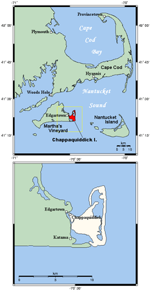
Chappaquiddick Island is a small island off the eastern end of the larger island of Martha's Vineyard and is part of the town of Edgartown, Massachusetts. The island became internationally recognized following the July 18, 1969 incident, where the car of U.S. Senator Edward M. "Ted" Kennedy was accidentally driven off the island's Dike Bridge, which fatally trapped his passenger, Mary Jo Kopechne, inside.
Until 2007, Martha's Vineyard and Chappaquiddick were connected by Norton Point Beach, a narrow, two-mile long strip which would occasionally become temporarily breached by the weather. In April 2007, a strong storm again breached the beach and the two islands became separated by a 300-yard (270 m) channel.[1] The southeastern point of this beach is called Wasque Point, a popular fishing spot for catching bluefish, striped bass, and other species.
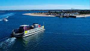
Privately owned barge-like ferries called On Time II and On Time III shuttle pedestrians, bicycles, and up to three cars at a time between Chappaquiddick and downtown Edgartown on Martha's Vineyard. Two ferries run during the summer months and one during the off-season.[citation needed] The island has just one business, a combination general store and automobile mechanic's garage, which is only open in the summer.[citation needed] Besides the Dike Bridge, tourists come to the isolated island to visit the MyToi Gardens, a small Japanese garden created amidst the native brush.
Origin
The name Chappaquiddick comes from an Indian word "cheppiaquidne" meaning "separated island", so named because this island is separated from Martha's Vineyard by a narrow strait or gut.[2][3]
The island has been historically spelled as "Chaubaqueduck" or, alternatively, "Chappaquidgick."[4]
The island was once mainly the home territory of the Chappaquiddick band of Wampanoag Indians, remaining exclusively theirs well into the nineteenth century. They still have a reservation of about 100 acres (40 hectares) of brush land in the interior.
Geography

On a map, Chappaquiddick can be located at 41°22′34″N 70°28′33″W / 41.37611°N 70.47583°W. The United States Census Bureau defines it as Block Group 1, Census Tract 2003 of Dukes County, Massachusetts. It has 15.915 km² (6.145 sq mi) of land.[5]
Administratively, it is part of the town of Edgartown and Dukes County. Socially, its residents form a tight-knit community and see themselves as distinctly separate from the rest of Edgartown.[citation needed] Longtime residents speak of "going to the mainland" when they travel to Edgartown and of "going to America" when (for example) they travel to Boston or Cape Cod.
As of the census [6] of 2010, there were only 179 people residing on the island. The racial makeup was 93.30% White, 1.68% African American, 0.56% Native American, 0.56% Asian, and 1.68% from two or more races. Hispanic or Latino of any race were 2.23% of the population.
Ted Kennedy incident
Events at Chappaquiddick Island gained international attention on July 19, 1969, when the dead body of Mary Jo Kopechne was discovered inside an overturned car in a channel on the island. The car belonged to U.S. Senator Edward M. "Ted" Kennedy, who had driven it off a bridge late on the previous night, the 18th. He did not report the incident to police until the following morning, the 19th.[7] Kopechne's body was finally recovered from the submerged car, and Kennedy entered a plea of guilty to a charge of "leaving the scene of an accident after causing injury". He received a sentence of two months in jail, which was suspended.
See also
- Cape Poge Lighthouse
- Edgartown Yacht Club Regatta
References
- ↑ Sigelman, Nelson (19 April 2007). "Storm breaches Norton Point Beach". Martha's Vineyard Times. Retrieved 30 April 2007.
- ↑ "GNIS Geographic Names Information System Query". USGS.
- ↑ (Steel; Douglas-Lithgow 1909; MGB 1932).
- ↑ Smithsonian Institution, Bureau of American Ethnology. Washington, DC: Government Printing Office. Bulletin 30 – Handbook of American Indians North of Mexico, edited by Frederick Webb Hodge, part 1 published in 1907, part 2 published in 1910. Use either code US-T142/B30/PT1/1907/p# or US-T142/B30/PT2/1910/p#. B30/pt1/1907/p238
- ↑ Block Group 1, Census Tract 2003, Dukes County United States Census Bureau
- ↑ Block Group 1, Census Tract 2003, Dukes County United States Census Bureau
- ↑ – 1969 Year in Review: Chappaquiddick – http://www.upi.com/Audio/Year_in_Review/Events-of-1969/Chappaquiddick/12303189849225-7/ –
External links
- Martha's Vineyard Vacation Tips
- Chappy Ferry website
- Chappaquiddick Wampanoag
- Mytoi Gardens
- Wasque Reservation
Coordinates: 41°22′34″N 70°28′33″W / 41.37611°N 70.47583°W