Changal, Tajikistan
From Wikipedia, the free encyclopedia
| Changal | |
|---|---|
 Changal | |
| Coordinates: 39°31′23″N 67°30′11″E / 39.52306°N 67.50306°ECoordinates: 39°31′23″N 67°30′11″E / 39.52306°N 67.50306°E | |
| Country |
|
| Province | Sughd |
| District | Panjakent District |
Changal is a village in north-west Tajikistan. It is located in Panjakent District in Sughd province.[1]
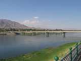
Changal is a western suburb of Panjakent and is located on the Zeravshan River. It is a border settlement with Uzbekistan and lies on the road from Panjakent to Samarkand.
The economy is based on fishing, using the resources of the river.
References
- ↑ Falling rain gazetteer
External links

This article is issued from Wikipedia. The text is available under the Creative Commons Attribution/Share Alike; additional terms may apply for the media files.