Chain Home Low
From Wikipedia, the free encyclopedia

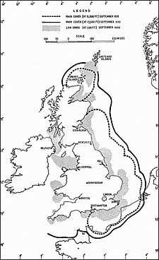
Radar Coverage 1939-1940

Margam CHL Station, 2012
Later in World War II, 3 GHz-frequency Chain Home Extra Low (CHEL) radar were often co-sited with CHL sites. As the name implies, these sets provided radar coverage at even lower altitudes than was possible with Chain Home Low.
List of Chain Home Low sites
- Anstruther, Fife
- Ballymartin, County Down, Northern Ireland
- Bamburgh, Northumberland
- Bard Hill, Holt, Norfolk
- Bawdsey, Suffolk
- Beachy Head, Sussex –
- Beer Head, Devon
- Bembridge, Isle of Wight
- Bempton, Yorkshire
- Ben Hough, Tiree
- Bexhill, Sussex
- Blackhead, County Antrim, Northern Ireland
- Bolt Tail, Devon
- Boniface Down, Isle of Wight
- Carsaig, Isle of Mull
- Cleadon, County Durham
- Clett, Shetland Islands
- Cockburnspath, Borders
- Cocklaw, Peterhead, Aberdeenshire
- Covehithe, Suffolk (CHEL site)[3]
- Crannoch Hill, Banff, Banffshire
- Craster, Northumberland
- Cregneash, Isle of Man
- Cresswell, Northumberland
- Cromarty, Ross and Cromarty
- Crustan, Orkney Islands
- Deerness, Orkney Islands
- Doonies Hill, Gregness, Aberdeen
- Dover –
- Downhill, County Londonderry, Northern Ireland
- Dunderhole Point, near Tintagel, Cornwall
- Dunnet Head, near Thurso, Caithness
- Dunwich, Suffolk –
- Easington, Yorkshire
- Eorodale, Isle of Lewis
- Fair Isle
- Fairlight, Sussex –
- Foreness Point, Kent –
- Formby, Lancashire
- Glenarm, County Antrim, Northern Ireland
- Goldsborough, Whitby, Yorkshire
- Great Orme, Llandudno, North Wales
- Greian Head, Isle of Barra
- Grutness, Sumburgh, Shetland Islands
- Happisburgh, Norfolk
- Hartland Point, Devon
- Hawcoat, Barrow in Furness, Lancashire
- Highdown Hill, Angmering, Sussex
- Hopton, Norfolk
- Humberston, Lincolnshire
- Hythe, Kent
- Islivig, Isle of Lewis
- Jacka, Portloe, Cornwall
- Kendrom, Kilmaluag, Isle of Skye
- Kete, Dale, Pembrokeshire
- Kilchiaran, Isle of Islay
- Kingswear, Devon
- Kinley Hill, Seaham, County Durham
- The Law, Carnoustie, Angus
- Margam, Margam Country Park, Neath Port Talbot
- Mark's Castle, Land's End, Cornwall
- Minehead, Minehead, Somerset
- Mossy Bottom, Shoreham, West Sussex
- Navidale, Helmsdale, Sutherland
- Needles, Isle of Wight
- North Foreland, Kent
- Oxwich, Swansea
- Pen Oliver, Lizard, Cornwall
- Pen y Bryn, Caernarfonshire
- Point of Stoer, Sutherland
- Poling, West Sussex –
- Prestatyn, Denbighshire
- Rame Head, Cornwall
- Ramsgate, Kent
- Ravenscar, North Yorkshire
- Roddans Port, County Down, Northern Ireland
- Rodel Park, Rodel, Harris, Western Isles
- Rosehearty, Aberdeenshire
- St Bee's Head, Pembrokeshire
- St Cyrus, Aberdeenshire
- St Davids Head, Pembrokeshire[4]
- St Twynells, Pembrokeshire
- Sango, Durness, Sutherland
- Saxa Vord, Unst, Shetland
- Shotton, County Durham
- Skendleby, Lincolnshire
- South Ronaldsay, Orkney
- South Stack, Anglesey
- Strumble head, Pembrokeshire
- Swansea Bay, Glamorgan
- Trevose Head, Cornwall
- Truleigh Hill, Bramber, West Sussex –
- Ulbster, Wick, Caithness
- Ventnor, Isle of Wight
- Walton on Naze, Essex
- Warden Point,Isle of Sheppey, Kent
- Watsness, Walls, Shetland
- Westburn, Aberdeen
- Westcliff, Portland, Dorset
- Whitehawk, Brighton, East Sussex
- Whitstable, Kent
- Worth Matravers, Swanage, Dorset
- This list is incomplete; you can help by expanding it.
See also
Notes
- ↑ 1.0 1.1 "The prototype CH system - 1939... Chain, Home... Operational". Bournemouth University. 1995-2009. Retrieved 23 August 2009.
- ↑ "The prototype CH system - Chain Home Low (CHL)". Bournemouth University. 1995-2009. Retrieved 23 August 2009.
- ↑ Chain Home Extra Low Station K163, Heritage Gateway. Retrieved 2012-11-01.
- ↑ Anon. "St David's Head". Experience Pembrokeshire. PLANED. Retrieved 21 June 2012.
References
- Batt, Reg., The Radar Army: Winning the War of the Airwaves (1991, Robert Hale, London) ISBN 0-7090-4508-5
- Bowen, E.G., Radar Days, Institute of Physics Publishing, Bristol, 1987., ISBN 0-7503-0586-X
- Bragg, Michael., RDF1 The Location of Aircraft by Radio Methods 1935-1945, Hawkhead Publishing, Paisley 1988 ISBN 0-9531544-0-8 The history of ground radar in the UK during World War II
- Brown, Louis., A Radar History of World War II, Institute of Physics Publishing, Bristol, 1999., ISBN 0-7503-0659-9
- Latham, Colin & Stobbs, Anne., Radar A Wartime Miracle, Sutton Publishing Ltd, Stroud 1996 ISBN 0-7509-1643-5 A history of radar in the UK during World War II told by the men and women who worked on it.
- Latham, Colin & Stobbs, Anne., Pioneers of Radar (1999, Sutton, England) ISBN 0-7509-2120-X
- Zimmerman, David., Britain's Shield Radar and the Defeat of the Luftwaffe, Sutton Publishing Ltd, Stroud, 2001., ISBN 0-7509-1799-7
External links
This article is issued from Wikipedia. The text is available under the Creative Commons Attribution/Share Alike; additional terms may apply for the media files.