Chaek
From Wikipedia, the free encyclopedia
| Chaek Чаек | |
|---|---|
 Chaek | |
| Coordinates: 41°55′48″N 74°30′36″E / 41.93000°N 74.51000°ECoordinates: 41°55′48″N 74°30′36″E / 41.93000°N 74.51000°E | |
| Country | Kyrgyzstan |
| Province | Naryn Province |
| Elevation | 1,682 m (5,518 ft) |
| Time zone | UTC +5 |
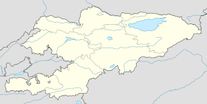
Chaek (Kyrgyz: Чаек) is a village in Naryn Province of Kyrgyzstan on the A361 highway which crosses the north of the province. It is about 100km west of Kochkor and 45km west of Lake Son-Kul. It is the largest of several villages in an agricultural valley. Further west the scenery becomes more dramatic.
This article is issued from Wikipedia. The text is available under the Creative Commons Attribution/Share Alike; additional terms may apply for the media files.