Ch'iyar Jaqhi
From Wikipedia, the free encyclopedia
| Ch'iyar Jaqhi | |
|---|---|
 Ch'iyar Jaqhi | |
| Elevation | 4,937 m (16,198 ft)[1] |
| Location | |
| Location |
Bolivia, Oruro Department |
| Range | Andes |
| Coordinates | 19°17′S 66°27′W / 19.283°S 66.450°WCoordinates: 19°17′S 66°27′W / 19.283°S 66.450°W |
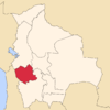
Ch'iyar Jaqhi (Aymara ch'iyara black,[2] jaqhi precipice, cliff,[3] "black cliff", hispanicized spelling Chiar Jakke) is a 4,937 metres (16,198 ft) high mountain located in the Andes in Bolivia. It is situated in the Oruro Department, Sebastián Pagador Province (Santiago de Huari Municipality), Condo "C" Canton.[4] It lies between the Jatun Wila Qullu in the south west and the Wila Qullu in the north east. The river Qullpa Jawira originates near the mountain.
References
- ↑ lib.utexas.edu Detailed map of the area
- ↑ www.katari.org Aymara-Spanish dictionary: Ch'iyara (adj.) - Color negro.
- ↑ www.ucb.edu.bo Despeñadero: s. Jaqhi
- ↑ Santiago de Huari Municipality: population data and map
| ||||||||||||||
This article is issued from Wikipedia. The text is available under the Creative Commons Attribution/Share Alike; additional terms may apply for the media files.
