Central Queensland
| Central Queensland | |
|---|---|
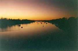
 The Fitzroy River as it passes through Rockhampton. | |
| Population | 190,000 (2005)[1] |
| LGA(s) | Banana, Central Highlands, Gladstone, Isaac, Rockhampton, Whitsunday, Woorabinda |
| State electorate(s) | Rockhampton, Bundaberg, Gladstone, Burnett, Hervey Bay |
| Federal Division(s) | Capricornia |
Central Queensland is an ambiguous geographical division of Queensland (a state in Australia) that centres on the eastern coast, around the Tropic of Capricorn. Its major regional centre is Rockhampton and the Capricorn Coast and the area extends west to the Central Highlands at Emerald, north to the Mackay Regional Council southern boundary, and south to Gladstone. The region is also known as Capricornia. As this is an unofficial area, the boundary lines remain unclear causing some dispute over Mackay Regional Council as part of Capricornia and Central Queensland, or part of the Tropical North of Queensland. Residents of Mackay Regional Council can sometimes receive official mail from both Townsville and Rockhampton due to this regional dispute.
Economically, Central Queensland is an important centre of primary industries. Even so, Central Queensland includes the Bowen Basin which is rich in high quality coking coal, the Port of Gladstone produces 40% of the state's export earnings, the Fitzroy River is the second-largest river system in Australia and commands significant water resources such as Fairbairn Dam. Gladstone has a significant aluminium smelter, Rockhampton is the undisputed beef capital of Australia, and the region produces approximately 50% of the state's electricity. [citation needed]
Citrus canker outbreak
In 2004, an orchard on Evergreen farm was the site of the first detection of citrus canker in Central Queensland. A significant part of the citrus growing industry was devastated when a total of 6,000 acres (24 km2) of crop had to be destroyed so the disease would not spread across the country.[2] In 2005 several fresh outbreaks were reported so the eradication expanded to include private backyard trees.[3] The outbreak's cause has not been fully explained despite a federal inquiry.[2] In 2009 authorities from the Government of Queensland declared the eradication program complete.
Communities
For this purpose the area of Central Queensland was restricted to the areas encircled by the Dawson Highway between Gladstone and Springsure; the Gregory Highway between Springsure and Clermont, and the Peak Downs Highway between Clermont and enters North Queensland via Mackay - extended right to the eastern coastline.
Major cities in the region are Emerald, Gladstone and Rockhampton. Some communities on the Capricorn Coast include Byfield, Yeppoon, Great Keppel Island, Emu Park and Cawarral.
See also
References
- ↑ "Population Growth: Highlights and Trends, Central Queensland 2005". Retrieved 2008-04-15.
- ↑ 2.0 2.1 "Spot of Trouble". Landline. 2009-03-29.
- ↑ "Citrus canker outbreak to impact on residents". ABC News Online. Australian Broadcasting Corporation. 7 September 2005. Retrieved 2008-03-29.
External links
| |||||||||||||||||
Coordinates: 23°26′22.97″S 144°53′09.69″E / 23.4397139°S 144.8860250°E