Caversham Lock
| ||||||||||||||||||||||||||||||||||||||||||||||||||||||||||||||||||||||||||||||||||||||||||||||||||||||||||||||||||||||||||||||||||||||||||||||||||||||||||||||||||||||||||||||||||||||||||||||||||||||||||||||||||||||||||||||||||||||

Caversham Lock is a lock and weir situated on the River Thames in England at Reading, Berkshire. The lock is connected to De Bohun Island, a somewhat larger than normal lock island. The original lock was built by the Thames Navigation Commissioners in 1778.
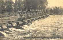
The weir is almost parallel to the lock and carries a footbridge across the river.
The island contains a typical lock-keeper's house, and until recently there was also a boat yard and boat house used by the Environment Agency's river patrol and maintenance services. As of November 2007, proposals to redevelop the island and some adjoining land are under discussion.
History
A weir, mill, ferry and flash lock on the site were referenced in 1493 when granted to Notley Abbey. The pound lock opened in 1778, but the lock house, long promised, was not built until after 1819. In 1871 Reading Corporation planned to build a swingbridge over the lock cut upstream of the lock, but this was not implemented. The lock was rebuilt in 1875.[2]
Access to and across the lock
The lock is not far from Reading railway station and is easily accessible from the centre of Reading.
The lock can also be reached from the Lower Caversham area of the cross-river suburb of Caversham via the weir and island, which provides a pedestrian route to the centre of Reading.
Reach above the lock
Soon after the lock is Reading Bridge followed by Fry's Island in the middle of the river. The built up part of Reading continues on the southern side to Caversham Bridge, to which is attached Pipers Island. The northern bank passes through the suburb of Caversham, where St Mary's Island is close to the bank.Reading Amateur Regatta is held annually in June between St Mary's Island and Caversham Bridge. Reading Festival is held on August Bank Holiday at Little John's Farm on Richfield Avenue near Caversham Bridge. During the festival a temporary structure, Reading Festival Bridge, links the site with parking and camping areas on the open meadows on the north bank. Here the Chiltern Hills can be seen in the background.

On the south bank, after the open space, is Tilehurst, where the river turns north with the two islands of Appletree Eyot and Poplar Island in the centre of the river. The railway runs parallel to the river for some way on a high brick embankment, and further upstream on the southern bank is Purley-on-Thames. On the northern bank Mapledurham House comes into view as the river continues northwards towards Mapledurham Lock.
The Thames Path follows the southern bank to Mapledurham lock.
Sports clubs
- Reading Rowing Club
- Reading Canoe Club
- Reading University Boat Club
See also
- Locks on the River Thames
- Crossings of the River Thames
- Islands in the River Thames
External links
| Wikimedia Commons has media related to Caversham Lock. |
| Next lock upstream | River Thames | Next lock downstream |
| Mapledurham Lock 7.08 km (4.40 mi) [3] |
Caversham Lock Grid reference: SU718740 |
Sonning Lock 4.23 km (2.63 mi)[3] |
| Next crossing upstream | River Thames | Next crossing downstream |
| Reading Bridge | Caversham Lock Grid reference: SU718740 |
Sonning Bridge & Sonning Backwater Bridges |
| Next island upstream | River Thames | Next island downstream |
| Fry's Island | De Bohun Island Grid reference: SU718740 |
View Island |
References
- ↑ 1.0 1.1 1.2 "A User's Guide to the River Thames". PDF file. Environmental Agency. 2009. pp. 29–30. Retrieved 7 November 2012. Dimensions given in metres
- ↑ Fred. S. Thacker The Thames Highway: Volume II Locks and Weirs 1920 - republished 1968 David & Charles
- ↑ 3.0 3.1 "Environment Agency Distances between locks on the River Thames". web page. Environmental Agency. 19 November 2012. Retrieved 20 November 2012. Distances given in km