Caturrita
From Wikipedia, the free encyclopedia
| Caturrita | |
|---|---|
| Bairro | |
 | |
 | |
| Coordinates: 29°40′13.58″S 53°50′26.15″W / 29.6704389°S 53.8405972°WCoordinates: 29°40′13.58″S 53°50′26.15″W / 29.6704389°S 53.8405972°W | |
| Country | Brazil |
| State | Rio Grande do Sul |
| Municipality/City | Santa Maria |
| District | District of Sede |
| Area | |
| • Total | 3.8756 km2 (1.4964 sq mi) |
| Population [1] | |
| • Total | 3,211 |
| • Density | 830/km2 (2,100/sq mi) |
| Adjacent bairros | Agroindustrial, Chácara das Flores, Divina Providência, Nova Santa Marta, Passo d'Areia, Salgado Filho, Santo Antão. |
| Website | Official site of Santa Maria |
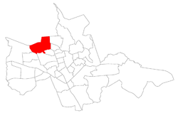
Caturrita[2] ("Monk Parakeet") is a bairro in the District of Sede in the municipality of Santa Maria, in the Brazilian state of Rio Grande do Sul. It is located in north Santa Maria.
Villages
The bairro contains the following villages: Caturrita, Vila Bela União, Vila Jordânia, Vila Negrine, Vila Nossa Senhora da Conceição, Vila Portão Branco, Vila Santa Rita, Vila São José.
Gallery of photos
References
See also
- pt:Caturrita (Santa Maria) - this article in Portuguese Wikipedia;
| ||||||||
This article is issued from Wikipedia. The text is available under the Creative Commons Attribution/Share Alike; additional terms may apply for the media files.
