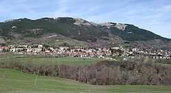
Carpegna
From Wikipedia, the free encyclopedia
| Carpegna | ||
|---|---|---|
| Comune | ||
| Comune di Carpegna | ||
 | ||
| ||
 Carpegna | ||
| Coordinates: 43°47′N 12°20′E / 43.783°N 12.333°E | ||
| Country | Italy | |
| Region | Marche | |
| Province | Pesaro e Urbino (PU) | |
| Frazioni | Genghe, Le Frazioni, Pietrino | |
| Government | ||
| • Mayor | Angelo Francioni | |
| Area | ||
| • Total | 28.3 km2 (10.9 sq mi) | |
| Population (28 February 2009[1]) | ||
| • Total | 1,673 | |
| • Density | 59/km2 (150/sq mi) | |
| Demonym | Carpegnoli | |
| Time zone | CET (UTC+1) | |
| • Summer (DST) | CEST (UTC+2) | |
| Postal code | 61021 | |
| Dialing code | 0722 | |
| Website | Official website | |
Carpegna is a comune (municipality) in the Province of Pesaro e Urbino in the Italian region Marche, located about 100 km west of Ancona and about 50 km southwest of Pesaro.
Carpegna borders the following municipalities: Belforte all'Isauro, Borgo Pace, Frontino, Mercatello sul Metauro, Montecopiolo, Pennabilli, Piandimeleto, Pietrarubbia, Sant'Angelo in Vado, Sestino.
The Monte Carpegna nearby is a ski resort. The communal territory is included in the Sasso Simone and Simoncello Regional Park.
References
- ↑ All demographics and other statistics: Italian statistical institute Istat.
External links
This article is issued from Wikipedia. The text is available under the Creative Commons Attribution/Share Alike; additional terms may apply for the media files.
