Carmen Municipality
| Carmen | ||
|---|---|---|
| Municipality | ||
| ||
 | ||
 Carmen | ||
| Coordinates: 18°38′35″N 91°49′50″W / 18.64306°N 91.83056°WCoordinates: 18°38′35″N 91°49′50″W / 18.64306°N 91.83056°W | ||
| Country | Mexico | |
| State | Campeche | |
| Municipal seat | Ciudad del Carmen | |
| Government | ||
| • Municipal president | José Ignacio Seara Sierra (2006-09) | |
| Area | ||
| • Total | 9,720.09 km2 (3,752.95 sq mi) | |
| Population (2005) | ||
| • Total | 199,988 | |
| • Density | 21/km2 (53/sq mi) | |
| Time zone | CST (UTC−6) | |
| • Summer (DST) | CDT (UTC−5) | |
| Created | 1916 | |
| Demonym | Carmeios o Carmelitas | |
| Postal Code | 24180 | |
| Website | www.carmen.gob.mx/ | |
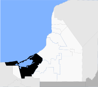
Carmen is one of the 11 municipalities that make up the Mexican state of Campeche. It is situated at the south-west of the state, on and around the Laguna de Términos. The municipal seat, and largest settlement, is Ciudad del Carmen.
The name "Carmen" is in honour of 16 July, the feast of Nuestra Señora del Carmen, after the date in 1717 when Spanish colonial authorities finally expelled the pirates from the island now known as Isla del Carmen.
History and geography
The municipality of Carmen borders to the north with the Gulf of Mexico; to the west with the municipality of Palizada; and to the east with the municipalities of Champotón, Escárcega and Candelaria. It covers a total surface area of 9,720.09 km².
Demographics
The 2005 census reported a population of 199,988 persons. Of these, 4,151 spoke one of 25 indigenous languages used in the municipality, predominantly Ch'ol and Yucatec Maya.
Population centres in the municipality include:
- Ciudad del Carmen, the municipal seat
References
- Link to tables of population data from Census of 2005 INEGI: Instituto Nacional de Estadística, Geografía e Informática
- Carmen Enciclopedia de los Municipios de México
External links
- Ayuntamiento de Carmen Official website (Spanish)
- Municipio de Carmen from official Campeche state government website (Spanish)
| |||||||||||

