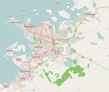
| Höfuðborgarsvæðið |
|---|
|
The Höfuðborgarsvæði area |
| Country |
Iceland |
|---|
| Area |
|---|
| • Total |
1,062 km2 (410 sq mi) |
|---|
| Population (2013) |
|---|
| • Total |
203,678 |
|---|
| • Density |
192/km2 (500/sq mi) |
|---|
Greater Reykjavík (Icelandic: Stór-Reykjavík, Höfuðborg or Höfuðborgarsvæðið, "the capital region") is a name used collectively for Reykjavík and six municipalities around it.[1][2] The area is by far the largest urban area in Iceland.[3] Each municipality has its independent elected council. With a population of 200,852, Greater Reykjavík comprises over 60% of the population of Iceland in an area that is only just over 1% of the total size of the country.[4] Municipal governments cooperate extensively in various fields; for example with waste policy, shared public transport and a joint fire brigade.
Size and population
Of the seven municipalities in the Greater Reykjavík Area, Reykjavík is by far the most populated with 117,764 inhabitants and Kjósarhreppur is the least populated with 210 inhabitants. Kjósarhreppur is however the largest of the eight with 287.7 km2 (111.1 sq mi) of land and Seltjarnarnes is the smallest with 2.3 km2 (0.89 sq mi).
References
Coordinates: 64°08′00″N 21°56′00″W / 64.13333°N 21.93333°W / 64.13333; -21.93333


