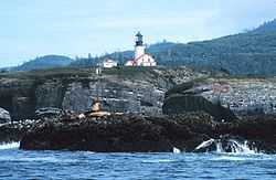
Cape Flattery Light
 | |
| Location | Neah Bay, Washington |
|---|---|
| Coordinates | 48°23′30″N 124°44′12″W / 48.3917°N 124.7366°WCoordinates: 48°23′30″N 124°44′12″W / 48.3917°N 124.7366°W |
| Year first lit | 1857 |
| Automated | 1977 |
| Foundation | Surface |
| Tower shape | Conical |
| Height | 65 ft |
| Original lens | First order Fresnel lens (removed) |
Cape Flattery Lighthouse is a lighthouse in the U.S. state of Washington. It is located near the Strait of Juan de Fuca and Neah Bay.
It was built in 1854 based on the design by Ammi B. Young. Its first light was displayed from a first-order lens in 1857 and was Washington Territory's third lighthouse. The house with a 65-foot (20 m) tower from the center still stands. A fog signal building with a 12-inch (30 cm) steam whistle was built on the island in 1872. The original first-order lens was replaced by a fourth-order lens in 1932, then with a modern optic lens in 1977.
Although closed to the public, it can be viewed from Cape Flattery via a short 30-minute walk. The lighthouse lies on Tatoosh Island, which is named after Chief Tatooche of the Makah Tribe.[1] It is the northernmost lighthouse on the West Coast of the continental United States.


References
- ↑ Elyea, Winifred. 1929. "History of Tatoosh Island" Washington Historical Quarterly, 1929, Vol. 20, No. 3, p. 223-227, Washington University State Historical Society, retrieved 9 April 2013