Cape Aya
From Wikipedia, the free encyclopedia
This article is about the promontory. For the artist, see Aya (artist). For the slovak rock band, see AYA (band). For other uses, see AYA (disambiguation).
| Cape Aya Мис Айя | |
|---|---|
 Cape Aya | |
| Country |
|
| Region | Sevastopol |
| Coordinates | 44°25′44″N 33°38′56″E / 44.42889°N 33.64889°ECoordinates: 44°25′44″N 33°38′56″E / 44.42889°N 33.64889°E |
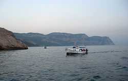
Cape Aya ("the holy one" in Greek, Άγια) is a rocky promontory jutting out into the Black Sea southeast of Balaklava. This 13-km-long offspur of the Crimean Mountains separates Laspi Bay (to the east) from Balaklava Bay (to the west). The highest point is Blue Cliff, or Kokiya-Kiya (559 metres). A storm off Cape Aya is the subject of one of Aivazovsky's paintings. A Soviet guided missile system was located on Cape Aya. The headland is full of grottoes; it is protected as a national zakaznik.[1]
References
- ↑ Marine Protected Areas for Whales, Dolphins and Porpoises Erich Hoyt - 2012 "The area between Cape Aya and Cape Fiolent, included in this MPA proposal, has also been identified as important habitat for all three cetaceans.
This article is issued from Wikipedia. The text is available under the Creative Commons Attribution/Share Alike; additional terms may apply for the media files.