Cantalupo Ligure
From Wikipedia, the free encyclopedia
| Cantalupo Ligure | |
|---|---|
| Comune | |
| Comune di Cantalupo Ligure | |
 | |
 Cantalupo Ligure | |
| Coordinates: 44°43′N 9°3′E / 44.717°N 9.050°ECoordinates: 44°43′N 9°3′E / 44.717°N 9.050°E | |
| Country | Italy |
| Region | Piedmont |
| Province | Province of Alessandria (AL) |
| Frazioni | Pallavicino, Borgo Adorno, Pessinate, Semega, Campana, Zebedassi, Besante, Arborelle, Colonne, Pertuso, Prato, Merlassino, Costa Merlassino |
| Area | |
| • Total | 24.0 km2 (9.3 sq mi) |
| Elevation | 383 m (1,257 ft) |
| Population (Dec. 2004) | |
| • Total | 552 |
| • Density | 23/km2 (60/sq mi) |
| Demonym | Cantalupesi |
| Time zone | CET (UTC+1) |
| • Summer (DST) | CEST (UTC+2) |
| Postal code | 15060 |
| Dialing code | 0143 |
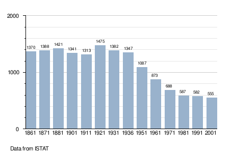
Cantalupo Ligure is a comune (municipality) in the Province of Alessandria in the Italian region Piedmont, located about 110 km southeast of Turin and about 40 km southeast of Alessandria. As of 31 December 2004, it had a population of 552 and an area of 24.0 km².[1]
The municipality of Cantalupo Ligure contains the frazioni (subdivisions, mainly villages and hamlets) Pallavicino, Borgo Adorno, Pessinate, Semega, Campana, Zebedassi, Besante, Arborelle, Colonne, Pertuso, Prato, Merlassino, and Costa Merlassino.
Cantalupo Ligure borders the following municipalities: Albera Ligure, Borghetto di Borbera, Dernice, Montacuto, Roccaforte Ligure, and Rocchetta Ligure.
Demographic evolution
References
This article is issued from Wikipedia. The text is available under the Creative Commons Attribution/Share Alike; additional terms may apply for the media files.