Camp Mountain, Queensland
| Camp Mountain Moreton Bay, Queensland | |||||||||||||
|---|---|---|---|---|---|---|---|---|---|---|---|---|---|
| Coordinates | 27°23′42″S 152°52′25″E / 27.39500°S 152.87361°ECoordinates: 27°23′42″S 152°52′25″E / 27.39500°S 152.87361°E | ||||||||||||
| Population | 1,258 (2011) | ||||||||||||
| Postcode(s) | 4520 | ||||||||||||
| Location | 20 km (12 mi) from Brisbane | ||||||||||||
| LGA(s) | Moreton Bay Region | ||||||||||||
| State electorate(s) | Ferny Grove | ||||||||||||
| Federal Division(s) | Ryan | ||||||||||||
| |||||||||||||
Camp Mountain is a rural locality northwest of Brisbane, Queensland, Australia, near Samford.[1] It is 20 km north-west of the Brisbane central business district. Parts of it are within the Brisbane Forest Park and a lookout and recreation area is accessible off Mount Nebo Road.
Until 1955 the train line to Dayboro traversed the area and in 1947 was the location of Queensland's worst railway accident.
Demographics
In the 2011 Census the population of Camp Mountain is 1,258, 51% female and 49% male.
The median/average age of the Camp Mountain population is 41 years of age, 4 years above the Australian average.
81.7% of people living in Camp Mountain were born in Australia. The other top responses for country of birth were England 6.4%, New Zealand 1.8%, Netherlands 1%, Italy 0.9%, South Africa 0.6%.
92.1% of people speak English as their first language 1% German, 0.6% Dutch, 0.6% Cantonese, 0.6% Italian, 0.3% Hungarian.
Heritage listings
Camp Mountain has a number of heritage-listed sites, including:
- 20 Upper Camp Mountain Road: Selector's Hut (former)[2]
-
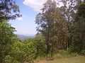
Camp Mountain — view of Brisbane city
-

Camp Mountain — looking towards the Glass House Mountains
References
- ↑ "Camp Mountain (entry 45376)". Queensland Place Names. Queensland Government. Retrieved 11 January 2014.
- ↑ "Selector's Hut (former) (entry 29110)". Queensland Heritage Register. Queensland Heritage Council. Retrieved 2013-07-11.