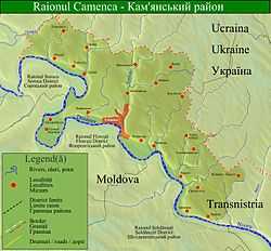
Camenca District
| Camenca | |
|---|---|
| District (Raion) | |
 | |
| Country |
|
| Administrative center | Camenca |
| Government | |
| • Heads of the State Administration of the Camenca District and the Camenca City | Petr Mustya |
| Area | |
| • Total | 434.5 km2 (167.8 sq mi) |
| Population (2010) | |
| • Total | 24,363[1] |
| Time zone | EET (UTC+2) |
| • Summer (DST) | EEST (UTC+3) |
Camenca District is a district of Transnistria, Moldova. Its seat is the town of Camenca (Romanian: Camenca; Russian: Каменка, Kamenka, Ukrainian: Kamianka, Polish: Kamionka). The district contains this town and 12 communes (a total of 23 localities, including the small villages/hamlets):
|
|
| |
Camenca is located along the river Dniester. It is the northernmost sub-district of Transnistria. According to the 2004 Census in Transnistria, the population of the sub-district is 27,284 people, including 13,048 (47.82%) Moldovans (Romanians), 11,610 (42.55%) Ukrainians, 1,880 (6.89%) Russians, 43 (0.16%) Gagauzians, 59 (0.22%) Bulgarians, 9 (0.03%) Romas, 10 (0.04%) Jews, 447 (1.64%) Poles, 85 (0.31%) Belarussians, 26 (0.10%) Germans, 16 (0.06%) Armenians, and 51 (0.19%) others.
The sub-district is home to the Dniester Sanatorium, the oldest health resort in Transnistria. In 2001, election officials for the Transnitrian presidential election announced that sitting president Igor Smirnov received 103.6 percent of the vote in this region.
List of Heads of the State Administration of the Camenca District and the Camenca City
- Petr Vasilyevich Mustya (? - )
References
- ↑ на 1.01.2010, в т.ч. городское население 9 404 чел. (ГОСУДАРСТВЕННАЯ СЛУЖБА СТАТИСТИКИ МИНИСТЕРСТВА ЭКОНОМИКИ ПРИДНЕСТРОВСКОЙ МОЛДАВСКОЙ РЕСПУБЛИКИ. СОЦИАЛЬНО-ЭКОНОМИЧЕСКОЕ РАЗВИТИЕ ПРИДНЕСТРОВСКОЙ МОЛДАВСКОЙ РЕСПУБЛИКИ. 2009)
External links
Coordinates: 48°00′N 28°43′E / 48.000°N 28.717°E
