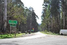
Cambarville, Victoria
| Cambarville Victoria | |
|---|---|
 | |
 Cambarville | |
| Coordinates | 37°34′S 145°54′E / 37.567°S 145.900°ECoordinates: 37°34′S 145°54′E / 37.567°S 145.900°E |
| Postcode(s) | 3779 |
| LGA(s) | Shire of Yarra Ranges |
| State electorate(s) | Gembrook |
| Federal Division(s) | McEwen |
Cambarville is a bounded rural locality in Victoria, Australia. Much of its area is part of the Yarra Ranges National Park. Its Local government area is the Shire of Yarra Ranges.
It is notable for its giant Mountain Ash (Eucalyptus regnans) trees within the Cumberland Memorial Scenic Reserve, and relics from former sawmills and gold mining. The Big Culvert is located nearby on the Marysville - Woods Point Road, which was historically part of the Yarra Track.
Cambarville was impacted by the 2009 Black Saturday bushfires, and was the location of the death of the only firefighter killed during the fires. David Balfour, 47, from Gilmore, ACT, was killed on the night of 17 February when a burnt-out 50 m (160 ft) mountain ash tree fell on him while he was attaching a hose to a fire tanker.[1]
References
- ↑ Murdoch, Lindsay (18 February 2009). "Dead firefighter professional with young family". The Age. Fairfax Media. Retrieved 13 February 2011.
Bibliography
- Thomas, Ann. Wilks Creek Bridge at Marysville, Victoria. 1993.
- Stacpoole, H. (Ed). Tracks to the Jordan. Lowden, Kilmore, 1973.
External links
![]() Media related to Cambarville, Victoria at Wikimedia Commons
Media related to Cambarville, Victoria at Wikimedia Commons