Caldera, Chile
| Caldera | |||||
|---|---|---|---|---|---|
| City and Commune | |||||
 | |||||
| Coordinates (city): 27°04′S 70°50′W / 27.067°S 70.833°WCoordinates: 27°04′S 70°50′W / 27.067°S 70.833°W | |||||
| Country | Chile | ||||
| Region | Atacama Region | ||||
| Province | Copiapó Province | ||||
| Government[1][2] | |||||
| • Type | Municipality | ||||
| • Alcalde | Patricia González (UDI) | ||||
| Area[3] | |||||
| • Total | 4,666.6 km2 (1,801.8 sq mi) | ||||
| Population (2012 Census)[3] | |||||
| • Total | 16,000 | ||||
| • Density | 3.4/km2 (8.9/sq mi) | ||||
| • Urban | 13,540 | ||||
| • Rural | 194 | ||||
| Sex[3] | |||||
| • Men | 7,237 | ||||
| • Women | 6,497 | ||||
| Time zone | CLT (UTC−4) | ||||
| • Summer (DST) | CLST (UTC−3) | ||||
| Area code(s) | 56 + 52 | ||||
| Website | Municipality of Caldera | ||||

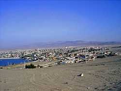
Caldera is a port city and commune in the Copiapó Province of the Atacama Region in northern Chile. It has an excellent harbor, protected by breakwaters, being the port city for the productive mining district centering on Copiapó to which it is connected by the first railroad constructed in Chile.
Geography and climate
| Caldera | ||||||||||||||||||||||||||||||||||||||||||||||||||||||||||||
|---|---|---|---|---|---|---|---|---|---|---|---|---|---|---|---|---|---|---|---|---|---|---|---|---|---|---|---|---|---|---|---|---|---|---|---|---|---|---|---|---|---|---|---|---|---|---|---|---|---|---|---|---|---|---|---|---|---|---|---|---|
| Climate chart (explanation) | ||||||||||||||||||||||||||||||||||||||||||||||||||||||||||||
| ||||||||||||||||||||||||||||||||||||||||||||||||||||||||||||
| ||||||||||||||||||||||||||||||||||||||||||||||||||||||||||||
Caldera lies about 75 km (47 mi) west of Copiapó at the Pacific. The climate is very dry and hot, because of its location on the Atacama desert's coast. However, lately the climate has become colder due to the climatic change. The commune spans an area of 4,666.6 km2 (1,802 sq mi).[3]
History
In 1687, Englishman Edward Davis reached the Playa Bahia Inglesa 6 km (4 mi) south of Caldera. In 1840, William Wheelwright of the Pacific Steam Navigation Company visited the region of Caldera. On his proposal the first railway was created in the year of 1851 from Caldera to Copiapó. Its inauguration was on Christmas Day in 1851. Caldera became an important port for the exportation of minerals. The city itself was officially founded on 23 September 1850.
The city has been struck by earthquakes and tsunamis several times the major ones being that of 1868, 1877 and 1922. During the 1891 Chilean Civil War, Caldera Bay outside the city became the site of the Battle of Caldera Bay where torpedo boats loyal to Manuel Balmaceda sunk the rebel ironclad Blanco Encalada.
Demographics
In 1903, 2,130 people lived in Caldera. According to the 2002 census of the National Statistics Institute, Caldera had 13,734 inhabitants (7,237 men and 6,497 women). Of these, 13,540 (98.6%) lived in urban areas and 194 (1.4%) in rural areas. The population grew by 13.9% (1,673 persons) between the 1992 and 2002 censuses.[3]
Tourist attractions
The church of San Vicente de Paul (dated 1862) and the cave of Padre Negro are worth visiting. Padre Velásquez painted biblical motifs in the cave in 1978. There is a nice beach at Bahía Inglesa.
Caldera also has a paleontological museum, the Museo Paleontológico de Caldera.
Economy
Mainstays of the economy are copper ore mining and cultivation of citrus plants which are exported via the port. Fishing and tourism play also an important role. The nice beaches attract many visitors.
Administration
As a commune, Caldera is a third-level administrative division of Chile administered by a municipal council, headed by an alcalde (mayor) who is directly elected every four years. The 2008-2012 mayor is Brunilda González Ánjel (PPD).[1][2]
Within the electoral divisions of Chile, Caldera is represented in the Chamber of Deputies by Mr. Alberto Robles (PRSD) and Mr. Giovanni Calderón (UDI) as part of the 6th electoral district, (together with Tierra Amarilla, Vallenar, Freirina, Huasco and Alto del Carmen). The commune is represented in the Senate by Isabel Allende Bussi (PS) and Baldo Prokurica Prokurica (RN) as part of the 3rd senatorial constituency (Atacama Region).
Gallery
-
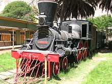
Locomotora Copiapó, first train in Chile, 1851-1860
-

Orbicular granite from Orbicular Granite Nature Sanctuary, near Caldera
-

Blossoming desert near Caldera, 2005
-

Blossoming desert in 2005

References
- ↑ 1.0 1.1 (Spanish) "Municipality of Caldera". Retrieved 27 January 2011.
- ↑ 2.0 2.1 (Spanish) "Asociación Chilena de Municipalidades". Retrieved 27 January 2011.
- ↑ 3.0 3.1 3.2 3.3 3.4 (Spanish) "National Statistics Institute". Retrieved 8 September 2010.
External links
- (Spanish) Municipality of Caldera
| |||||||||||||
