Cadell, South Australia
From Wikipedia, the free encyclopedia
| Cadell South Australia | |
|---|---|
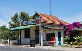 Store and post office | |
 Cadell | |
| Coordinates | 34°02′0″S 139°46′0″E / 34.03333°S 139.76667°ECoordinates: 34°02′0″S 139°46′0″E / 34.03333°S 139.76667°E |
| Population | 460 (2006 Census)[1] |
| Location | 192 km (119 mi) from Adelaide |
| LGA(s) | Mid Murray Council |
Cadell is a town situated near the north western edge of South Australia's Riverland on the inside of the large southward bend in the Murray River. The town is named after Captain Francis Cadell, who was the navigator on Charles Sturt's exploration of Murray River.[2] Cadell lies in the middle of a citrus growing area and is also home to a low security prison for men, the Cadell Training Centre.[2][3][4]
References
| Wikimedia Commons has media related to Cadell, South Australia. |
- ↑ Australian Bureau of Statistics (25 October 2007). "Cadell (Urban Centre/Locality)". 2006 Census QuickStats. Retrieved 2008-10-23.
- ↑ 2.0 2.1 "Cadell, South Australia". Travelmate.com.au. Retrieved 2006-09-08.
- ↑ "Correctional facilities in South Australia: Cadell Training Centre". Australian Institute of Criminology. 2005-03-11. Archived from the original on 2006-05-06. Retrieved 2006-09-08.
- ↑ "Cadell Training Centre". Prison & Prisoner Management. Department of Justice Correctional Services and South Australian Government. ©1997, 1998. Retrieved 2006-09-08.
| |||||
| |||||
This article is issued from Wikipedia. The text is available under the Creative Commons Attribution/Share Alike; additional terms may apply for the media files.