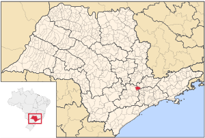
Cabreúva
Coordinates: 23°18′27″S 47°07′59″W / 23.30750°S 47.13306°W
| Coat of arms | |
|---|---|
 | |
| Statistics | |
| State: | São Paulo |
| Meso-region: | Paulista Macro-Metropolitan Meso-Region |
| Microrregions: | Sorocaba |
| Founded: | March 24 |
| Location: | 23.915/23°18'27" S, 47.132/47°7'59" W |
| Area: | 259.8 km² |
| Population: | 36,106 (2004) Ranked 312nd |
| Population density: | 138.98/km² |
| Elevation: | 640 m |
| Postal code: | 13315-xxx |
| Area/distance code: | (00)55-11 |
| Website: | www.cabreuva.sp.gov.br |
| Population Statistics | |
| Urban: | 25,760 |
| Rural: | 7,340 |
| Other | |
| Literacy rate: | 90.05% |
Cabreúva is a municipality (município) in the state of São Paulo in Brazil. The population in 2003 is 36,106, the density is about 138/km² the area is 261 km² The elevation is 640 m. This place name comes from the Tupi words Kaburé-Iwa, the tree of the owl and is known by the aboriginals.
History
The city was established in the beginning of 18th century by a member of the Martins and Ramos family, from the city of Itu, passed by the Tietê river and searched a place located and founded a situated valley between the three mountain ranges (derived from the Tupi language) - they are Japi, Guaxatuba and Taguá. The area is cultivated with sugar canes which gave the origin to its local economy for some decades, which received its nickname of the city, Terra da Pinga/Land of Pinga.
The name of this city originates from the Cabreúva tree of the medium-brown type (Myrocarpus frondosus, of the family Leguminosae-Papilionoideae).
Geography
Its landscape is dominated by two detached geographical formations: the mountain ranges of (Japi, Guaxatuba and Taguá) and the Tietê river. The altitudes vary between 640 m in the center of the city up to 1,200 m Serra do Japi. The city has 261 km², of which 96 km² are urban and 165 km² are rural.
Population history
| Year | Population | Change | Density |
|---|---|---|---|
| 2001 | 33,100 | - | 127.41/km² |
| 2004 | 36,106 | - | 138.98/km² |
Demographics
According to the 2000 IBGE Census, the population was 33,100, of which 25,760 are urban and 7,340 are rural. Its life expectancy for the city was 71.14 years. The literacy rate was at 90.05%.
Events
- March 24: Day of the municipal anniversary
- (Portuguese) SITE VISITE CABREUVA
- (Portuguese) Homepage of Cabreúva
- (Portuguese) Cabreúva on citybrazil.com.br
- (Portuguese) Cabreúva's Newspaper - Caleidoscópio
- (Portuguese) Cabreúva's Newspaper - Mais Cabreúva
- (Portuguese) Cabreúva's Telephone directory
| North: Indaiatuba and Itupeva | ||
| West: Itu |
Cabreúva | East: Jundiaí |
| South: Pirapora do Bom Jesus and Araçariguama |