Buthrotum
| Buthrotum Boυθροτόν (Greek) Butrint (Albanian) | |
|---|---|
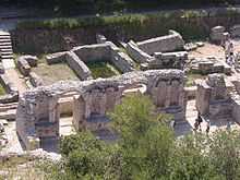
 Remains of a theatre and part of the agora | |
 | |
| Location | Ksamil, Vlorë County, Albania |
| Region | Chaonia |
| Coordinates | 39°44′46″N 20°01′13″E / 39.74611°N 20.02028°ECoordinates: 39°44′46″N 20°01′13″E / 39.74611°N 20.02028°E |
| Type | Settlement |
| Site notes | |
| Official name: Butrint | |
| Type: | Cultural |
| Criteria: | iii |
| Designated: | 1992 (16th session) |
| Reference No. | 570 |
| Region: | Europe and North America |
| Extensions: | 1999 |
| Endangered: | 1997–2005 |
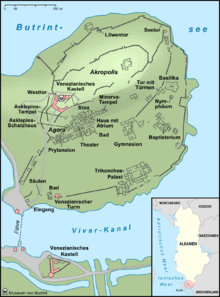
Buthrotum (Albanian: Butrint; Latin: Buthrōtum; from Ancient Greek: Βουθρωτόν, Bouthrōtón) was an ancient Greek and later Roman city in Epirus.[1][2][3] In modern times it is an archeological site in Sarandë District, Albania, some 14 kilometres south of Sarandë and close to the Greek border. It was known in antiquity as Βουθρωτόν (Bouthrōton) or (Βουθρώτιος) Bouthrōtios[4] in Ancient Greek and Buthrotum in Latin. It is located on a hill overlooking the Vivari Channel and part of the Butrint National Park. Inhabited since prehistoric times, Buthrotum was a city of the Greek tribe of the Chaonians, later a Roman colony and a bishopric. It entered into decline in Late Antiquity, before being abandoned during the Middle Ages after a major earthquake flooded most of the city.
History
Ancient
Bouthroton was originally a town within the region of Epirus. It was one of the major centres of the Greek tribe of the Chaonians,[5] with close contacts to the Corinthian colony of Corcyra (modern Corfu). According to the Roman writer Virgil its legendary founder was the seer Helenus, a son of the king Priam of Troy, who had married Andromache and moved West after the fall of Troy. The Greek historian Dionysius of Halicarnassus, as does the Latin poet Virgil, wrote that Aeneas visited Bouthroton after his own escape from the destruction of Troy.
The earliest archaeological evidence of settled occupation dates to between 10th and 8th centuries BC, although some claim that there is earlier evidence of habitation in the 12th century BC.[6] Excavation at Bouthroton has yielded Proto-Corinthian pottery of the 7th century and then Corinthian and Attic pottery of the 6th century, however there are no indications of a prehistoric settlement.[7] The original settlement probably sold food to Corfu and had a fort and sanctuary. Bouthroton was in a strategically important position due its access to the Straits of Corfu. By the 4th century BC it had grown in importance and included a theatre, a sanctuary to Asclepius and an agora. Around 380 BC, the settlement was fortified with a new 870 metres long wall, with five gates, enclosing an area of four hectares.[8]
In 228 BC Buthrotum became a Roman protectorate alongside Corfu and Romans increasingly dominated Buthrotum after 167 BC. In the next century, it became a part of a province of Macedonia. In 44 BC, Caesar designated Buthrotum as a colony to reward soldiers that had fought on his side against Pompey. The local landholder Titus Pomponius Atticus objected to his correspondent Cicero who lobbied against the plan in the Senate. As a result, Buthrotum received only small numbers of colonists.
In 31 BC, Emperor Augustus fresh from his victory over Mark Antony and Cleopatra at the battle of Actium renewed the plan to make Buthrotum a veterans' colony. New residents expanded the city and the construction included an aqueduct, a Roman bath, houses, a forum complex, and a nymphaeum. During that era the size of the town was doubled.[9]

In the 3rd century AD, an earthquake destroyed a large part of the town, levelling buildings in the suburbs on the Vrina Plain and in the forum of the city centre. Excavations have revealed that city had already been in decline. However, the settlement survived into the late antique era, becoming a major port in the province of Old Epirus. The town of late antiquity included the grand Triconch Palace, the house of a major local notable that was built around 425.

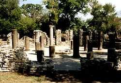
In the early 6th century, Buthrotum became the seat of a bishop and new construction included a large baptistry, one of the largest such Paleochristian buildings of its type, and a basilica. The walls of the city were extensively rebuilt, most probably at the end of the 5th century, perhaps by Emperor Anastasius. The Ostrogoths under Indulf raided the Ionian coast in 550 and may have attacked Buthrotum. Evidence from the excavations shows that importation of commodities, wine and oil from the Eastern Mediterranean continued into the early years of the 7th century when the early Byzantine Empire lost these provinces. In this, it follows the historical pattern seen in other Balkan cities, with the 6th to 7th century being a watershed for the transformation of the Roman world into the Early Middle Ages.
By the 7th century, following the model of classical cities throughout the Mediterranean, Buthrotum had shrunk to a much smaller fortified post and with the collapse of Roman power was briefly controlled by First Bulgarian Empire before being regained by the Byzantine Empire in the 9th century.
Medieval and Venetian Period
It remained an outpost of the empire fending off assaults from the Normans until 1204 when following the Fourth Crusade, the Byzantine Empire fragmented, Butrint falling to the breakaway Despotate of Epirus. In the following centuries, the area was a site of conflict between the Byzantines, the Angevins of southern Italy, and the Venetians, and the city changed hands many times. In 1267, Charles of Anjou took control of both Buthrotum and Corfu leading to further restorations of the walls and the Great Basilica.

The Republic of Venice purchased the area including Corfu from the Angevins in 1386; however, the Venetian merchants were principally interested in Corfu and Buthrotum once again declined. By 1572 the wars between Venice and the Ottoman Empire had left Buthrotum ruinous and at the order of Domenico Foscarini, the Venetian commander of Corfu, the administration of Buthrotum and its environs was shifted to a small triangular fortress associated with the extensive fish weirs. The area was lightly settled afterwards, occasionally being seized by the Ottoman Turks, in 1655 and 1718, before being recaptured by the Venetians. Its fisheries were a vital contributor to the supply of Corfu, and olive growing together with cattle and timber were the principal economic activities.[10]
._Venetian_enclave_facing_Corfu..jpg)
Modern
In 1797, Butrint came under French control when Venice ceded it to Napoleon as a part of the Treaty of Campo Formio. In 1799, the local Ottoman governor Ali Pasha Tepelena conquered it, and it became a part of the empire until Albanian independence in 1912. By that time, the site of the original city had been unoccupied for centuries and was surrounded by malarial marshes.
Archaeological excavations
The first modern archaeological excavations began in 1928 when the Fascist government of Benito Mussolini's Italy sent an expedition to Buthrotum. The aim was geopolitical rather than scientific, aiming to extend Italian hegemony in the area. The leader was an Italian archaeologist, Luigi Maria Ugolini who despite the political aims of his mission was a good archaeologist. Ugolini died in 1936, but the excavations continued until 1943 and the Second World War. They uncovered the Hellenistic and Roman part of the city including the "Lion Gate" and the "Scaean Gate" (named by Ugolini for the famous gate at Troy mentioned in the Homeric Iliad).
After the communist government of Enver Hoxha took Albania over in 1944, foreign archaeological missions were banned. Albanian archaeologists including Hasan Ceka continued the work. Nikita Khrushchev visited the ruins in 1959 and suggested that Hoxha should turn the area into a submarine base. The Albanian Institute of Archaeology began larger scale excavations in the 1970s. Since 1993 further major excavations have taken place led by the Butrint Foundation in collaboration with the Albanian Institute of Archaeology. Recent excavations in the western defences of the city have revealed evidence of the continued use of the walls, implying the continuation of life in the town. The walls themselves certainly seem to have burnt down in the 9th century, but were subsequently repaired.
After the collapse of the communist regime in 1992, the new democratic government planned various major developments at the site. The same year remains of Butrint were included in the UNESCO list of World Heritage Sites. A major political and economic crisis in 1997 and lobbying stopped the airport plan and UNESCO placed it on the List of World Heritage in Danger because of looting, lack of protection, management and conservation. Archaeological missions during 1994-9 uncovered further Roman villas and an early Christian church.[9]
The Albanian Government established the Butrint National Park in 2000. Its First Director was Auron Tare, followed by Raimond Kola. Butrint became an important center of cultural management and a great example how to manage this Heritage. With the support of Albanian institutions, The Butrint Foundation, The World Bank and UNESCO the situation was improved to the point that UNESCO removed the site from the danger list by 2005. The National Park was also made a UNESCO World Heritage Site during these years as well as a Ramsar Site.
Directions
Butrint is accessible from Saranda, along a road first built in 1959 for a visit by the Soviet leader Nikita Khrushchev. This road is being upgraded during summer 2010. The construction project is something of an environmental catastrophe and may yet threaten Butrint's World Heritage Site status. The ancient city is increasingly becoming a popular tourist destination, attracting day-trippers from the nearby Greek holiday island of Corfu. Hydrofoils (30 minutes) and ferries (90 minutes) run daily between the New Port in Corfu (city) and Saranda. Many visitors from Corfu use chartered coach services to visit Butrint from Saranda, which are often included in tickets to Albania from Corfu, and additionally, a regular public bus service runs between Saranda port and Butrint.
Notable people
- Saint Therinus, 3rd-century saint
- Saint Donatus of Evorea, 4th-century saint
See also
- Saranda
- Butrint National Park
- Tourism in Albania
- Albanian Riviera
- Tongo Island
- List of cities in Albania
- List of cities in ancient Epirus
References
- ↑ Borza, Eugene N. (1992). In the Shadow of Olympus: the Emergence of Macedon (Revised Edition). Princeton, New Jersey: Princeton University Press. "Speakers of these various Greek dialects settled different parts of Greece at different times during the Middle Bronze Age, with one group, the 'northwest' Greeks, developing their own dialect and peopling central Epirus. This was the origin of the Molossian or Epirotic tribes." "[...]a proper dialect of Greek, like the dialects spoken by Dorians and Molossians." "The western mountains were peopled by the Molossians (the western Greeks of Epirus)."
- ↑ Crew, P. Mack (1982). The Cambridge Ancient History - The Expansion of the Greek World, Eighth to Sixth Centuries B.C., Part 3: Volume 3 (Second Edition). Cambridge, UK: Cambridge University Press. "That the Molossians... spoke Illyrian or another barbaric tongue was nowhere suggested, although Aeschylus and Pindar wrote of Molossian lands. That they in fact spoke greek was implied by Herodotus' inclusion of Molossi among the Greek colonists of Asia Minor, but became demonstrable only when D. Evangelides published two long inscriptions of the Molossian State, set up p. 369 B.C at Dodona, in Greek and with Greek names, Greek patronymies and Greek tribal names such as Celaethi, Omphales, Tripolitae, Triphylae, etc. As the Molossian cluster of tribes in the time of Hecataeus included the Orestae, Pelagones, Lyncestae, Tymphaei and Elimeotae, as we have argued above, we may be confindent that they too were Greek-speaking."
- ↑ Hammond, NGL (1994). Philip of Macedon. London, UK: Duckworth. "Epirus was a land of milk and animal products.... The social unit was a small tribe, consisting of several nomadic or semi-nomadic groups, and these tribes, of which more than seventy names are known, coalesced into large tribal coalitions, three in number: Thesprotians, Molossians and Chaonians.... We know from the discovery of inscriptions that these tribes were speaking the Greek language (in a West-Greek dialect)"
- ↑ An Inventory of Archaic and Classical Poleis by Mogens Herman, ISBN 0-19-814099-1,2004, page 343,"Bouthroton (Bouthrotios)"
- ↑ Strabo. The Geography. Book VII, Chapter 7.5 (LacusCurtius).
- ↑ Ceka, Neritan; transl. Pranvera Xhelo (2002). Buthrotum: Its History & Monuments. Tirana: Cetis Tirana. p. 19. ISBN 99927-801-2-6.
- ↑ The Cambridge Ancient History, Volume 3, Part 3: The Expansion of the Greek World, Eighth to Sixth Centuries BC, p. 269, Cambridge University Press, ISBN 978-0-521-23447-4, 1982
- ↑ Ceka, p22
- ↑ 9.0 9.1 Hodges, Richard; Bowden, William; Lako, Kosta; Richard Andrews (2004). Byzantine Butrint: excavations and surveys 1994-1999. Oxbow Books. p. 54. ISBN 978-1-84217-158-5. Retrieved 8 January 2011.
- ↑ During his short career as an ensign in a Venetian regiment, 20-year old Casanova spent 3 days on Butrint guarding galley slaves cutting and loading timber on 4 galleys. He mentions the objective of this once-a-year routine was mainly to 'show the flag' and safeguard Venice's rights to that nearly deserted outpost. Giacomo Casanova, Histoire de ma vie, Librairie Plon, Paris, vol II, chap V, p. 198-199.
Further reading
- Ceka N., Butrint: A guide to the city and its monuments (Migjeni Books, Tirana 2005)
- Crowson A., "Butrint from the Air," Current World Archaeology, 14 (2006)
- Hodges, R.; Bowden, W.; Lako, K. (2004), Byzantine Butrint: Excavations and Surveys 1994-99, Oxford: Oxbow Books
- Richard Hodges and Matthew Logue, "The Mid-Byzantine Re-Birth of Butrint", Minerva 18, #3 (May/June 2007), pp. 41–43.
- Jarrett A. Lobell, Ages of Albania (Archeology magazine March/April 2006)
- Ugolini L. M., Butrinto il Mito D'Enea, gli Scavi (Istituto Grefico Tiberino, Rome 1937, Reprinted Istituto Italiano di Cultura, Tirana 1999)
External links
| Wikimedia Commons has media related to Butrint. |
| Wikivoyage has a travel guide for Butrint. |
| Wikisource has the text of the 1911 Encyclopædia Britannica article Butrinto. |
| Wikisource has the text of the 1911 Encyclopædia Britannica article Buthrotum. |
General information
- Butrint National Park
- Butrint at the Albanian National Trust (now Auron Expeditions)
- The Butrint Foundation
- Butrinti 2000 International Festival of Theater
- Photo Albums
- Visiting Butrint
History articles
- More information on Butrint from The History Channel
- Rome and Albanian history from Albania.com
- Albania's Long-lost Roman City, BBC
- In Pictures: Sights of Butrint, BBC
- 176 photos from the archeological site of Butrint
| |||||||
| |||||||||||||
| ||||||||||||||