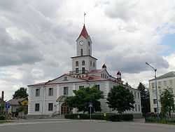
Busk, Ukraine
From Wikipedia, the free encyclopedia
| Busk Буськ | ||
|---|---|---|
 | ||
| ||
 | ||
| Coordinates: 49°58′0″N 24°37′0″E / 49.96667°N 24.61667°E | ||
| Country |
| |
| Oblast |
| |
| Raion | Busk Raion | |
| Area | ||
| • Total | 9.0 km2 (3.5 sq mi) | |
| Population (2006) | ||
| • Total | 8,896 | |
| Time zone | EET (UTC+2) | |
| • Summer (DST) | EEST (UTC+3) | |
| Postal code | 80500—80505 | |
| Area code(s) | +380-3264 | |
| Sister cities | Ropczyce | |
Busk (Ukrainian: Буськ; Polish: Busk) is a city located in Busk Raion in Lviv Oblast (province) of western Ukraine. The city's population was 8,896 as of the 2006 Ukrainian Census.
It is administrative center of the Busk Raion.
Busk was the birthplace of Yevhen Petrushevych, the president of the West Ukrainian National Republic.
History
Busk had a very active Jewish community before World War II. The first synagogue was built in 1502.[1] The old Jewish cemetery was renowned.
On July 1, 1941, German forces occupied Busk. The Jewish population was transferred to a ghetto then eliminated on May 21, 1943. 1500 Jews perished during this operation.[1]
International relations
Twin towns - Sister cities
Busk is twinned with
People
References
- ↑ 1.0 1.1 Porteur de mémoires, Père Patrick Desbois, Flammarion 2007
External links
- Official Web Page of the Busk District State Administrations of Lviv Oblast (Ukrainian)
- Wayback Machine Archive - Official site of the Busk District State Administration (Ukrainian)
- Site about Busk
- Site Busk
Coordinates: 49°58′N 24°38′E / 49.967°N 24.633°E
| ||||||||||||||||||
This article is issued from Wikipedia. The text is available under the Creative Commons Attribution/Share Alike; additional terms may apply for the media files.
