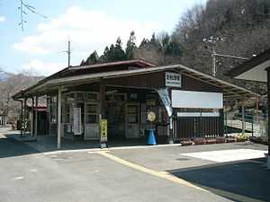
Bushū-Hino Station
From Wikipedia, the free encyclopedia
Bushū-Hino Station 武州日野駅 | |
 | |
|---|---|
| Bushū-Hino Station, March 2006 | |
| Location | |
| Prefecture | Saitama (See other stations in Saitama) |
| City | Chichibu |
| Neighborhood etc. | 822-2 Arakawa-hino |
| Postal code | 369-1803 |
| (in Japanese) | 秩父市荒川日野822-2 |
| History | |
| Year opened | 1930 |
| Rail services | |
| Operator(s) | Chichibu Railway |
| Line(s) | Chichibu Main Line |
| Statistics | 388 passengers/day (FY2000) |
Bushū-Hino Station (武州日野駅 Bushū-Hino-eki) is a railway station in Chichibu, Saitama, Japan, operated by the Chichibu Railway.[1]
Lines
Bushū-Hino Station is served by the Chichibu Main Line from Hanyū to Mitsumineguchi, and is located 67.7 km from Hanyū.[1] It is also served by through services to and from the Seibu Chichibu Line.
Station layout
The station is staffed and consists of an island platform serving two tracks.[2]
Platforms
| 1 | ■Chichibu Main Line | for Chichibu, Yorii, Kumagaya, and Hanyū, and through services via Seibu Chichibu Line |
| 2 | ■Chichibu Main Line | for Mitsumineguchi |
Adjacent stations
| « | Service | » | ||
|---|---|---|---|---|
| Chichibu Main Line | ||||
| Bushū-Nakagawa | Local | Shiroku | ||
| Paleo Express: no stop | ||||
| Chichibuji: no stop | ||||
History
Bushū-Hino Station opened on 15 March 1930.[1]
Passenger statistics
In fiscal 2000, the station was used by an average of 388 passengers daily.[1]
Surrounding area
- Arakawa River
- National Route 140
- Chichibu Arakawa Junior High School
References
- ↑ 1.0 1.1 1.2 1.3 Terada, Hirokazu (July 2002). データブック日本の私鉄 [Databook: Japan's Private Railways]. Japan: Neko Publishing. p. 193. ISBN 4-87366-874-3.
- ↑ Kawashima, Ryozo (January 2011). 日本の鉄道 中部ライン 全線・全駅・全配線 第10巻 上越・秩父エリア [Railways of Japan - Chubu Line - Lines/Stations/Track plans - Vol 10 Joetsu & Chichibu Area]. Japan: Kodansha. p. 28/88. ISBN 978-4-06-270070-2.
External links
| Wikimedia Commons has media related to Stations of Chichibu Main Line. |
- Bushū-Hino Station information (Saitama Prefectural Government) (Japanese)
- Bushū-Hino Station timetable (Japanese)
Coordinates: 35°57′14.58″N 139°1′16.95″E / 35.9540500°N 139.0213750°E
This article is issued from Wikipedia. The text is available under the Creative Commons Attribution/Share Alike; additional terms may apply for the media files.