Burgwedel
From Wikipedia, the free encyclopedia
| Burgwedel | ||
|---|---|---|
| ||
 Burgwedel | ||
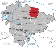
Location of Burgwedel within Hanover district 
 | ||
| Coordinates: 52°29′36″N 09°51′31″E / 52.49333°N 9.85861°ECoordinates: 52°29′36″N 09°51′31″E / 52.49333°N 9.85861°E | ||
| Country | Germany | |
| State | Lower Saxony | |
| District | Hanover | |
| Subdivisions | 7 districts | |
| Government | ||
| • Mayor | Dr. Hendrik Hoppenstedt | |
| Area | ||
| • Total | 151.96 km2 (58.67 sq mi) | |
| Elevation | 53 m (174 ft) | |
| Population (2012-12-31)[1] | ||
| • Total | 20,301 | |
| • Density | 130/km2 (350/sq mi) | |
| Time zone | CET/CEST (UTC+1/+2) | |
| Postal codes | 30938 | |
| Dialling codes |
05139, 05135 (Fuhrberg) | |
| Vehicle registration | H | |
| Website | www.burgwedel.de | |

Burgwedel is a town in the district of Hanover, in Lower Saxony, Germany. It is situated approximately 15 km northeast of Hanover.
Geography
History
Politics and Administration
Burgwedel consists of the following boroughs:
- Engensen
- Fuhrberg
- Großburgwedel (administrative see)
- Kleinburgwedel
- Oldhorst
- Thönse
- Wettmar
Religion
Protestant (Evangelical-Lutheran) Church
Roman Catholic Church
The members of the Roman Catholic St. Paul's parish community Burgwedel builds the second largest religious community of the town. St. Paul's belongs to the diocese of Hildesheim, which is part of the ecclesiastical province of Hamburg.
Further Christian Communities
Education and Culture
Schools
Libraries
Economics
Companies
Social Affairs
| |||||||
| Wikimedia Commons has media related to Burgwedel. |
References
This article is issued from Wikipedia. The text is available under the Creative Commons Attribution/Share Alike; additional terms may apply for the media files.
