Burghaun
| Burghaun | ||
|---|---|---|
 | ||
| ||
 Burghaun | ||
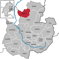
Location of Burghaun within Fulda district 
 | ||
| Coordinates: 50°42′N 09°43′E / 50.700°N 9.717°ECoordinates: 50°42′N 09°43′E / 50.700°N 9.717°E | ||
| Country | Germany | |
| State | Hesse | |
| Admin. region | Kassel | |
| District | Fulda | |
| Government | ||
| • Mayor | Alexander Hohmann | |
| Area | ||
| • Total | 65.04 km2 (25.11 sq mi) | |
| Elevation | 261 m (856 ft) | |
| Population (2012-12-31)[1] | ||
| • Total | 6,527 | |
| • Density | 100/km2 (260/sq mi) | |
| Time zone | CET/CEST (UTC+1/+2) | |
| Postal codes | 36151 | |
| Dialling codes | 06652 & 06653 | |
| Vehicle registration | FD | |
| Website | www.burghaun.de | |
Burghaun is a municipality in the district of Fulda in the state of Hesse in Germany.
Burghaun itself is a small town with about 3,800 residents. Following the administrative reorganization of Germany in 1972 when smaller communities were grouped together, Burghaun took in the nearby villages of Großenmoor, Gruben, Hechelmannskirchen, Hünhan, Langenschwarz, Rothenkirchen, Schlotzau and Steinbach.
The municipality of Burghaun (the town itself plus these nearby villages) currently has a total of about 7,000 inhabitants.
As the name "Burghaun" suggests, the town is in the valley of the Haune, a small river that flows into the river Fulda. Burghaun is situated about 5 km north of Hünfeld which, in turn, is about 18 km to the northeast of the city of Fulda. Burghaun is about 150 km northeast of Frankfurt.
References
- ↑ "Die Bevölkerung der hessischen Gemeinden". Hessisches Statistisches Landesamt (in German). July 2013.
External links
- Website of Burghaun (in German) with color photos
- Album of Burghaun in old black-and-white photos
- Jüdische Geschichte in Burghaun, Jewish history in Burghaun (in German)
| Wikimedia Commons has media related to Burghaun. |
| |||||||
