Bunbury, Cheshire
| Bunbury | |
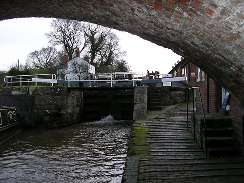
 Bunbury staircase locks |
|
 Bunbury | |
| Population | 1,308 (2001 Census)[1] |
|---|---|
| OS grid reference | SJ568580 |
| Civil parish | Bunbury |
| Unitary authority | Cheshire East |
| Ceremonial county | Cheshire |
| Region | North West |
| Country | England |
| Sovereign state | United Kingdom |
| Post town | TARPORLEY |
| Postcode district | CW6 |
| Dialling code | 01829 |
| Police | Cheshire |
| Fire | Cheshire |
| Ambulance | North West |
| EU Parliament | North West England |
| UK Parliament | Eddisbury |
Bunbury is a village and civil parish in the unitary authority of Cheshire East and the ceremonial county of Cheshire, England, south of Tarporley, north west of Nantwich, and on the Shropshire Union Canal. According to the 2001 Census, the parish had a population of 1,308.[1]
History
Some prominent gentlemen of the county of Cheshire met in Bunbury on 23 December 1642 and drew up the Bunbury Agreement. The terms of the agreement were intended to keep Cheshire neutral during the English Civil War. It proved to be a forlorn hope, because of the national strategic importance of Cheshire and of the city port of Chester meant that national interests overruled local ones.
Bunbury was a victim of the Blitz during World War II. German aircraft returning from a night raid on Liverpool in 1940 jettisoned surplus bombs over the village, obliterating Church Row (the houses have since been rebuilt). The blast causing minor damage to the exterior of St Boniface's Church and the immediate area. The original village centre surrounding the church was hit, damaging shops beyond repair.[2] This has largely caused the current centre to evolve in the geographical heart of the village.
Four old villages have combined to form the modern-day Bunbury. These are:
- Higher Bunbury (centred around the church and the Dysart Arms),
- Lower Bunbury (the main part of the village today),
- Bunbury Heath (essentially School Lane) and
- Bunbury Common (from Higher Bunbury towards Bunbury Locks).
The last three have coalesced to form a single village. The River Gowy is a natural division between Higher and Lower Bunbury.
Landmarks
Bunbury Locks is a working wharf with some "high-rise" staircase locks and canal horse stables.
Bunbury Mill is a watermill dating from 1844, although there has been a mill on this site since 1290.[3] Following damage caused by a flood in 1960, the mill closed in 1966. It was restored to working order and reopened to the public as a museum by North West Water Authority (later part of United Utilities). It was closed again in 2010, and passed into the ownership of the Bunbury Watermill Trust, who have reopened it to visitors.[4]
Community

The main lane in Bunbury is Bunbury Lane which contains three shops (butcher, general convenience store/Post Office and fish & chip shop), two hairdressers and three pubs. These are the Nags Head, the Dysart Arms (Cheshire Dining Pub of the Year 2009) and the Yew Tree (formerly the Crewe Arms) which re-opened in 2010.
Bunbury Aldersey C of E Primary school is in School Lane.
The parish church is dedicated to Saint Boniface and is built on the highest point of the village. It is over 1,000 years old and is built on an older pagan site. This was a collegiate church built in the 14th century; the nave arcades and aisle windows are about 100 years later than this. There is an alabaster effigy of the founder of the college, Sir Hugh Calveley, other effigies, and a 17th-century tomb. It was restored after bomb damage during the Second World War.[5] The old churchyard contains war graves of 5 soldiers of World War I[6] and the churchyard extension those of 4 soldiers and a naval officer of World War II.[7]
Bunbury has amenities such as a cricket pavilion, sports pitches, tennis courts, a scout hut (with a new one under construction in 2011) and a village hall. It also has some clubs and societies.
Sadlers Wells Woods is located near the A49 road. The wooded area was also mentioned in the Domesday Book written in the time of William the Conqueror.
See also
References
- ↑ 1.0 1.1 2001 Census: Bunbury CP, Office for National Statistics, retrieved 12 August 2007
- ↑ Thornber, Craig, Bunbury, retrieved 7 November 2008
- ↑ Bunbury Mill in Cheshire reopens to public, BBC, 12 March 2012, retrieved 14 July 2012
- ↑ Home, Bunbury Watermill Trust, retrieved 14 July 2012
- ↑ Betjeman, J., ed. (1968) Collins Pocket Guide to English Parish Churches: the North. London: Collins; p. 101
- ↑ CWGC Cemetery Report. Period obtained from casualty record.
- ↑ CWGC Cemetery Report. Breakdown obtained from casualty record.
External links
![]() Media related to Bunbury, Cheshire at Wikimedia Commons
Media related to Bunbury, Cheshire at Wikimedia Commons
| |||||||||||||||||