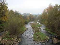
 Bukovec (help·info) (Polish: Bukowiec (info), German: Bukowetz) is a village in Frýdek-Místek District, Moravian-Silesian Region of the Czech Republic. It has 1,356 inhabitants (2001 census), 33.6% of the population are the Poles and 87.3% are Roman Catholics.[1] It is the easternmost village of the country and the first village in the Czech Republic through which the Olza River flows. It lies in the historical region of Cieszyn Silesia.
The village was established by Kazimierz, Duke of Cieszyn in 1353. The name of the village is derived from beech forests that grew there - buk is a Slavic root for beech. The first settlers lived mainly off the logging of local beech forests. After 200 years, the village gained a farming-pasture character. Pastures were established on nearby hills. The number of inhabitants rose very slowly. By 1647, only 20 people lived there. Settlers had many children and soon number of inhabitants rose. They lived in wooden houses.
Since the 18th century, villagers lived mainly off the transport of salt from Wieliczka to Jabłonków, farming, transport of wood and smithing. Later they worked in coal mining and metallurgy. From the interwar period until after World War II, smuggling was widespread, as in other villages near the borders.
The village has been traditionally Roman Catholic. The first church was built in June 1939. Bukovec is still locally known for its relatively slow pace of lifestyle. Villagers keep all cultural and religious traditions. Many of the traditional old wooden houses can still be seen.
Footnotes
References
- Cicha, Irena; Kazimierz Jaworski, Bronisław Ondraszek, Barbara Stalmach and Jan Stalmach (2000). Olza od pramene po ujście. Český Těšín: Region Silesia. ISBN 80-238-6081-X.
External links
|
|---|
| | |
* More than 10% of total population; 2001 census data. **Karviná fell under 10% in the 2001 census.
Villages with significant Polish population under the administration of another municipality are not listed. |
|
|
|---|
| Municipalities
in the Czech Republic | | |
|---|
| | Partly | |
|---|
| Municipalities
in Poland | |
|---|
| | Partly | |
|---|
| | Other articles | |
|---|
|
Coordinates: 49°32′58″N 18°49′25″E / 49.54944°N 18.82361°E / 49.54944; 18.82361


![]() Bukovec (help·info) (Polish: Bukowiec , German: Bukowetz) is a village in Frýdek-Místek District, Moravian-Silesian Region of the Czech Republic. It has 1,356 inhabitants (2001 census), 33.6% of the population are the Poles and 87.3% are Roman Catholics.[1] It is the easternmost village of the country and the first village in the Czech Republic through which the Olza River flows. It lies in the historical region of Cieszyn Silesia.
Bukovec (help·info) (Polish: Bukowiec , German: Bukowetz) is a village in Frýdek-Místek District, Moravian-Silesian Region of the Czech Republic. It has 1,356 inhabitants (2001 census), 33.6% of the population are the Poles and 87.3% are Roman Catholics.[1] It is the easternmost village of the country and the first village in the Czech Republic through which the Olza River flows. It lies in the historical region of Cieszyn Silesia.


