Bujang Valley

The Bujang Valley or Lembah Bujang is a sprawling historical complex and has an area of approximately 224 square km. Situated near Merbok, Kedah, between Gunung Jerai in the north and Muda River in the south, it is the richest archaeological area in Malaysia.[1]
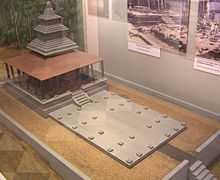
These archaeological remains show that there was a Hindu-Buddhist polity here. The name itself is roughly translated into "Dragon Valley". The area consists of ruins that may date more than 2000 years old. More than fifty ancient tomb temples, called candi (pronounce "chandi"), have also been unearthed. The most impressive and well-preserved of these is located in Pengkalan Bujang, Merbok. The Bujang Valley Archaeological Museum is also located here. In the area of Bujang Valley known as Sungai Batu, excavation have revealed jetty remains, iron smelting sites, and a clay brick monument dating back to 110AD, making it the oldest man-made structure to be recorded in Southeast Asia.[2]
Research also indicates that there was a Hindu-Buddhist kingdom here possibly as early as 110 CE.[3] The local rulers adopted Indian cultural and political models earlier than those of Kutai in eastern Borneo, in southern Celebes or Tarumanegara in western Java, where remains showing Indian influence have been found dating from the early 5th century. Relics found in the Bujang Valley are now on display at the archaeological museum. Items include inscribed stone caskets and tablets, metal tools and ornaments, ceramics, pottery, and Hindu icons.
For the past two decades, students from universities around Malaysia have been invited for research and have done their graduate works at the Valley. Much of the historical links is still vague considering not many of the scriptures and writings survive. Even the temples did not survive the onslaught of age because their wooden roofing has rotted and withered over the past 1200 years. The museum itself is inadequate and not organized, much of the findings are elsewhere scattered from Museum Negara to Singapore (which once formed a part of Malaysia. Folk stories and oral history also provide place for a magnificent kingdom of jewels and gold. Outside peninsular and insular Southeast Asia, there is oral history in India that suggests the presence of golden chariots and jewels in hidden caves at Bujang Valley and Mount Jerai. Some visitors to the antiquity department at Muzium Negara has eye witness recollection of magnificent objects such as a 10 feet tall Raja Bersiung Throne and various idols and items from the Valley.
On 1 December 2013, it was reported that, a 1,200 year old Hindu Temple at the site, identified as Candi No. 11, had been demolished by a land developer.[4]
In the face of public criticism, the Kedah State Government sought to deflect blame by claiming that it was powerless to do anything because the land was privately owned and further, that the site had not been gazetted as a historical site.[5]
The Deputy Chief Minister II of Penang (a neighbouring state of Kedah), Dr P. Ramasamy, who visited the demolished ruins, was said to have learnt that the Merbok Land Office of Kedah had authorised the developer to clear the land after finding that there were "no historical sites" at the location.[6]
As at the time the Temple was reported demolished, the Federal Tourism and Culture Minister, Mr. Mohamed Nazri Abdul Aziz, had failed or neglected to respond to the situation, despite the fact that Lembah Bujang is Malaysia's richest archaeological site and home to South East Asia's oldest recorded man-made structure.[7][8]
History
Claudius Ptolemaeus (Greek: Κλαύδιος Πτολεμαῖος; c. 90 – c. 168), known in English as Ptolemy, was a Greek geographer, astronomer, and astrologer who had written about Golden Chersonese, which indicates trade with India and possibly China has existed since the 1st century AD.,[9][10]
Austronesians were remarkable sailors. The forests of Indonesia were rich in products sought after such as resins, wood and spices. Clove for instance was known to ancient Egyptians while the only place where it would grow at that time were the Moluccas in the eastern part of the Indonesia archipelago. Benzoin (laban jawi in Arabic) and camphor (kapur Barus) came from northern Sumatra. Possibly as early as the 4th century BC, merchants from the Western part of the Indonesia archipelago sailed west in search of new markets for their products and connected with South East India.
As early as the 1st century AD, Southeast Asia was the place of a network of coastal city-states, the centre of which was the ancient Khmer Funan kingdom in the south of what is now Vietnam. This network encompassed the southern part of the Indochinese peninsula and the western part of the Indonesian archipelago. These coastal cities traded with each other, and with India. They seem to have shared a common indigenous culture.
Gradually, the rulers of the western part of Indonesia adopted Indian cultural and political models e.g. proof of such Indian influence on Indonesian art in the 5th century, i. e. an Amaravati Buddha statue found in southern Sulawesi and a Sanskrit inscription found east of Jakarta.
Three inscriptions found in Palembang (South Sumatra) and on Bangka Island, written in a form of Malay and in an alphabet derived from the Pallava script, are proof that "Indonesians" had definitely adopted Indian models. These inscriptions reveal the existence of a Dapunta Hyang (lord) of Srivijaya who led an expedition against his enemies and who curses those who will not obey his law.
Being on the maritime route between western Indonesia and South India, the Malay peninsula was involved in this trade. Contact between the peninsula and the Tamil kingdoms had been very close during the regimes of the Pallava Kings (from the 4th to the 9th century) and Chola kings (from the 9th to the 13th century). This trade relations also led the rulers of the Malay peninsula to adopt Indian cultural and political models. Tamil sources mention the name of "Kadaram" i. e. Kedah and "Langkasugam" i. e. Langkasuka. [11]
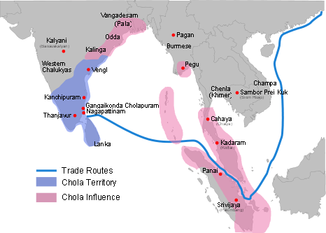
In the ancient city of Tanjore in Tamil Nadu in southern India are inscriptions dating from 1030 which mention the victory of Chola king Rajendra Chola I over some kingdoms in Southeast Asia. The name of "Kadaram" is amongst the places that Rajendra claims to have conquered.[12] The Cholas had a powerful merchant and naval fleet in the Indian Ocean and the Bay of Bengal. Three kinds of craft are distinguished by the author of the Periplus – light coasting boats for local traffic, larger vessels of a more complicated structure and greater carrying capacity, and lastly the big ocean-going vessels that made the voyages to Malaya, Sumatra, and the Ganges.[13]
Kedah inscriptions


In Kedah there are remains showing Buddhist and Hindu influences which has been known for about a century now from the discoveries reported by Col. Low and has recently been subjected to a fairly exhaustive investigation by Dr. Quaritch Wales. Dr. Wales investigated no fewer than thirty sites round about Kedah. The results attained show that this site was the location of a Hindu–Buddhist polity similar to those found in western Indonesia.[14]
An inscribed stone bar, rectangular in shape, bears the ye-dharmma formula in Pallava script of the 4th century, thus proclaiming the Buddhist character of the shrine near the find-spot (site I) of which only the basement survives. It is inscribed on three faces in Pallava script of the 6th century, possibly earlier.[14]
In Kedah an inscription in Sanskrit dated 1086 has been found. This was left by Kulothunga Chola I (of the Chola empire, Tamil country). This too shows the commercial contacts the Malay peninsula had with the Chola Empire.[15]
Books
- Wolters, O. W., Early Indonesian Commerce : a Study of the Origins, 2001, 1597401870
- Wolters, O. W., Early Southeast Asia : selected essays, Cornell University, 2008, ISBN 978-0-87727-773-6 / 0-87727-773-7
- Wolters, O. W., The Fall of Srivijaya in Malay History, Cornell University Press, 1970, ISBN 0-8014-0595-5, ISBN 0-8014-0595-5
See also
- Sultanate of Kedah
- Langkasuka
- Early History of Kedah
- Red Earth Kingdom / Chi Tu
References
- ↑ Bujang Valley impetus to tourism, By Subhadra Devan, 2010/09/19
- ↑ New interest in an older Lembah Bujang, 2010/07/25
- ↑ Lembah Bujang - Ancient Village or Settlement in Malaysia.
- ↑ http://www.themalaymailonline.com/malaysia/article/centuries-old-temple-ruins-in-bujang-valley-furtively-destroyed
- ↑ http://www.themalaymailonline.com/malaysia/article/after-uproar-kedah-scrambles-bid-to-salvage-lembah-bujang-ruins
- ↑ http://www.themalaymailonline.com/malaysia/article/after-uproar-kedah-scrambles-bid-to-salvage-lembah-bujang-ruins
- ↑ http://www.freemalaysiatoday.com/category/nation/2013/11/29/8th-century-temple-site-in-bujang-valley-demolished/
- ↑ http://www.themalaymailonline.com/malaysia/article/centuries-old-temple-ruins-in-bujang-valley-furtively-destroyed
- ↑ THE GOLDEN CHERSONESE
- ↑ THE GOLDEN CHERSONESE
- ↑ name=International2000>International Tamil Language Foundation (2000). The Handbook of Tamil Culture and Heritage. Chicago: International Tamil Language Foundation. p. 877.
- ↑ name=Arokiaswamy2000
- ↑ name=Sastri2000>Sastri, K.A. Nilakanta (2000) [1935]. Cholas (fifth printing ed.). Chennai: University of Madras. pp. 86 & 318.
- ↑ 14.0 14.1 Sastri, K.A. Nilakanta (1949). South Indian Influences in the Far East. Bombay: Hind Kitabs Ltd. pp. 82 & 84.
- ↑ Arokiaswamy, Celine W.M. (2000). Tamil Influences in Malaysia, Indonesia, and the Philippines. Manila s.n. p. 41.
External links
![]() Media related to Bujang Valley at Wikimedia Commons
Media related to Bujang Valley at Wikimedia Commons
- The Ancient Kingdom of Bujang Valley
- Bujang Valley Archaeological Museum, Bukit Batu Pahat
- Lembah Bujang: Kingdom lost . kingdom found
Coordinates: 5°44′16″N 100°24′50″E / 5.73778°N 100.414°E