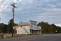
Brockway, Oregon
From Wikipedia, the free encyclopedia
| Brockway, Oregon | |
|---|---|
| Unincorporated community | |
 | |
 Brockway, Oregon | |
| Coordinates: 43°06′32″N 123°27′19″W / 43.10889°N 123.45528°WCoordinates: 43°06′32″N 123°27′19″W / 43.10889°N 123.45528°W | |
| Country | United States |
| State | Oregon |
| County | Douglas |
| Elevation | 571 ft (174 m) |
| Time zone | Pacific (PST) (UTC-8) |
| • Summer (DST) | PDT (UTC-7) |
| ZIP code | 97496 |
| GNIS feature ID | 1136094 |
Brockway, Oregon is an unincorporated community in Douglas County, Oregon, United States,[1] on Oregon Route 42, about nine miles southwest of Roseburg.
Originally known as Civil Bend, referring to the "...boisterous activity of visitors to the horseraces," the name was changed in 1889 when postal authorities objected to a name with two words. "Brockway" was chosen in honor of local farmer and pioneer B. B. Brockway.[2]
References
- ↑ "Brockway". Geographic Names Information System, U.S. Geological Survey. November 28, 1980. Retrieved October 5, 2011.
- ↑ McArthur, Lewis A.; Lewis L. McArthur (1982) [1928]. Oregon Geographic Names (Fifth Edition ed.). Portland, Oregon: Oregon Historical Society Press. p. 84. ISBN 0-87595-114-7.
| |||||||||||||||||
This article is issued from Wikipedia. The text is available under the Creative Commons Attribution/Share Alike; additional terms may apply for the media files.
