Bridger Mountains (Montana)
| Bridger Mountains | |
|---|---|
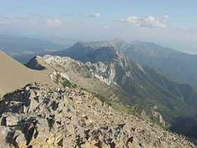 View of the Bridger Range looking south from the summit of Sacagawea Peak. | |
| Highest point | |
| Peak | Sacagawea Peak |
| Elevation | 9,665 ft (2,946 m) |
| Geography | |
<div style="padding:2px 2px 5px 2px;> | |
| Country | United States |
| State | Montana |
| Range coordinates | 45°53′N 110°58′W / 45.89°N 110.96°WCoordinates: 45°53′N 110°58′W / 45.89°N 110.96°W |
| Parent range | Rocky Mountains |
The Bridger Range (highest point: Sacagawea Peak 9665 ft/2945 m) is a subrange of the Rocky Mountains, in southern Montana in the United States. The range runs mostly in a north - south direction between Bozeman and Maudlow and is separated from the Gallatin Range to the south by Bozeman Pass. Bozeman Pass (5712 ft/1,741 m) is a narrow pass that lies between Bozeman and Livingston. Sacagawea Peak is a prominent peak visible to the northeast from Bozeman. Most of the range is within Gallatin National Forest.
Mountains

The Bridger Range has many named and unnamed peaks. Some of the most well known peaks are:
- Sacagawea Peak (9665 ft/2946 m)
- Hardscrabble Peak (9575 ft/2918 m)
- Naya Nuki Peak (9449 ft/2880 m)
- Saddle Peak ( 9162 ft/2793 m)
- Ross Peak (9004 ft/2744 m)
- Mount Baldy (8914 ft/2717 m)
- Bridger Peak (8635 ft/ 2632 m)
Skiing
The Bridger Range is also home to ski area Bridger Bowl. With the first rope tow installed in 1951, Bridger Bowl became a primarily locals mountain, the area has a top elevation of 8700 ft and a base elevation of 6100 ft. On average the ski area receives 350 inches of snow every year. Backcountry skiing is also very popular with snow being available on peaks such as Sacagawea from early November until late May/early June. Beginning the 2008-2009 ski season, Bridger Bowl started to allow backcountry travel from the ski area via access gates on the northern and southern boundaries.
Hiking
Though many hiking trails exist, Sacagawea Peak is a favorite hiking area in the Bridgers. The hike is a short, yet rather strenuous, 2.2 mile one-way trek through pine forest, alpine tundra and scree fields to the top of Sacagawea Peak. The Bridger Ridge Run is a 20 mile race which takes place mid-August. The race follows the ridge line from Fairy Lake to the southern end of the range.
History
The Native American Sacagawea led the Lewis and Clark Expedition through Bozeman Pass and some have suggested the pass should have been named after her instead of John Bozeman.
The range is named after Jim Bridger, who pioneered the Bridger Trail through mountains in southern Wyoming into the Bighorn Basin in 1864.
On January 10, 1938, Northwest Airlines Flight 2 crashed in the Bridger Mountains, killing all 10 aboard. This was the first fatal crash of a Northwest Airlines aircraft.
| Images of the Bridger Range | |||||||||
|---|---|---|---|---|---|---|---|---|---|
| |||||||||


See also
Notes
External links
| ||||||||||||||||||||