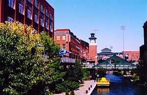
Bricktown, Oklahoma City
Coordinates: 35°27′59″N 97°30′33″W / 35.466419°N 97.509100°W

Bricktown is an entertainment district to east of downtown Oklahoma City, Oklahoma (United States). It was formerly a major warehouse district.[1] The major attractions of the district are the Chickasaw Bricktown Ballpark, the navigable Bricktown Canal, and the 16-screen Harkins movie theatre.[1] Toby Keith's I Love This Bar & Grill is located in Bricktown, as is the corporate headquarters of Sonic Drive-In.
Boundaries and management
The district's boundaries include the Oklahoma River on the south, I-235 on the east. The district is organized by Downtown Oklahoma City, The Bricktown Urban Design Committee established by the City of Oklahoma City oversees modifications to the buildings in the Bricktown district, with an eye toward preserving its 'warehouse district' flavor while allowing commercial and retail development. The general boundary of the Bricktown Core Development District is as follows: An area bordered generally by the BNSF Railway; Reno Avenue; Centennial Expressway; and the railroad right-of-way between Main and NE 1st.
History
Four railroad companies had freight operations east of the Santa Fe tracks in what is now Bricktown in the late 19th and early 20th century.[2] The first brick structures, which were typically only one or two stories, appeared between 1898 and 1903.[2] Larger brick buildings were constructed between 1903 and 1911, and the tallest brick buildings were built between 1911 and 1930.[2] Working class houses were built nearby.
Oklahoma City's first black newspaper, the Black Dispatch, was located in Bricktown at 228 E. First; it reported on the struggle to end racially segregated housing in the city. Also in that area was the first local chapter of the National Association for the Advancement of Colored People (NAACP), founded in the early 20th century to work for the civil rights of African Americans.[2]
The decline of the area began with the onset of the Great Depression, which diminished businesses in the area. The growth of eastern suburbs and subsidized highways during and after World War II attracted many residents to newer housing.[2] Railroads restructured and freight traffic moved to trucks and highways. By 1980, Bricktown had become a cluster of abandoned buildings.[2]
In the 1990s, mayor Ron Norick persuaded Oklahoma City residents to approve a series of tax incentives to lure new businesses, but these were not sufficient.[3] A visit to Indianapolis, Indiana, which had recently beat the city in a competition for a new airline maintenance plant, led him to believe that Oklahoma City needed a vibrant downtown. It lacked the range of activities and amenities to attract more residents and visitors.[3] Along with Greater Oklahoma City Chamber President Ray Ackerman, Norick and their staffs developed the Metropolitan Area Projects or MAPS, which approval led to the construction of the Bricktown ballpark and a tree-lined, mile-long canal through the district, as well as other projects in downtown.[3] The ballpark opened in 1998 and the canal opened in July 1999.[3] Water taxis carry visitors to different stops along the canal, including many restaurants, shops and nightclubs.
Arts and culture
The district contains a number of public sculptures and murals, including a monument to the Oklahoma Land Run.[1]
An annual Bricktown Art Festival is held in mid-July.[4]
Transportation
Amtrak's Heartland Flyer service to Fort Worth departs every morning from the old Santa Fe Depot, located by the west entrance to Bricktown, and returns in the evenings.
References
- ↑ 1.0 1.1 1.2 Bricktown Entertainment District, Travelok.com (accessed June 10, 2010).
- ↑ 2.0 2.1 2.2 2.3 2.4 2.5 Blackburn, Bob, "History of Bricktown," Bricktownokc.com (accessed June 10, 2010).
- ↑ 3.0 3.1 3.2 3.3 "Who Laid the First Brick – History". Bricktown Association. Retrieved 26 October 2011.
- ↑ TravelOK - Bricktown Art Festival (accessed June 10, 2010).
External links
- Bricktown Official Website
- Voices of Oklahoma interview with Ray Ackerman. First person interview conducted with Ray Ackerman on September 30, 2009. Original audio and transcript archived with Voices of Oklahoma oral history project.
| ||||||||||||||
| |||||||||||