Brekstad
| Brekstad | |
|---|---|
| City | |
 | |
 Brekstad | |
| Coordinates: 63°41′13″N 09°39′55″E / 63.68694°N 9.66528°ECoordinates: 63°41′13″N 09°39′55″E / 63.68694°N 9.66528°E | |
| Country | Norway |
| Region | Trøndelag |
| County | Sør-Trøndelag |
| District | Fosen |
| Municipality | Ørland |
| Declared city status | 2005 |
| Area[1] | |
| • Total | 1.76 km2 (0.68 sq mi) |
| Elevation[2] | 3 m (10 ft) |
| Population (2009)[1] | |
| • Total | 1,888 |
| • Density | 1,073/km2 (2,780/sq mi) |
| Time zone | CET (UTC+01:00) |
| • Summer (DST) | CEST (UTC+02:00) |
| Post Code | 7130 Brekstad |
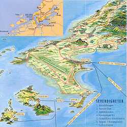
Brekstad is the administrative centre of the municipality of Ørland in Sør-Trøndelag county, Norway. It is located on the Trondheimsfjord at the entrance to the Stjørnfjord. It is about 5 kilometres (3.1 mi) south of Uthaug and about 7 kilometres (4.3 mi) west of Austrått and Ottersbo.
The 1.76-square-kilometre (430-acre) city has a population (2009) of 1,888. This gives the village a population density of 1,073 inhabitants per square kilometre (2,780 /sq mi).[1] Brekstad received city status on 8 October 2005, thus becoming the 95th city in Norway.[3]
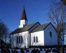
Brekstad is the seat of Fosen District Court, Brekstad road maintenance department, and NAV Fosen work. The major employers are Ørland Main Air Station / Ørland Airport, Mascot Høie linen factory, Coop Fosen, and Tine Midt-Norge. Ørland Church and Ørland cultural center are both located in the city.
Brekstad has connections with the Hurtigruten boat to Trondheim, Hitra, Frøya, Storfosna, and Kristiansund. The Brekstad–Valset Ferry has regular service across the Trondheimsfjord from Brekstad to Valset in Agdenes. There are also road connections to Bjugn.
History
Brekstad post office was established in 1883.[4] Brekstad is also the site of Skjeggehaugen, from the Old Norse word haugr meaning mound. Skjeggehaugen is an ancient burial mound which measures about 50 to 60 metres (160 to 200 ft) across and from 6 to 7 metres (20 to 23 ft) in height. It is located about 60 metres (200 ft) northeast of Ørland Church.[5]
Media gallery
-

Brekstad area map
-

Ørland church
-
Brekstad, east view
-

Brekstad, west view
References
- ↑ 1.0 1.1 1.2 Statistisk sentralbyrå (1 January 2009). "Urban settlements. Population and area, by municipality.".
- ↑ "Brekstad" (in Norwegian). yr.no. Retrieved 2011-01-13.
- ↑ Store norske leksikon. "Brekstad" (in Norwegian). Retrieved 2011-01-13.
- ↑ Bakken, Jon, ed. (1997). Posten 350 år: historisk utvikling i kommunene Ørland, Bjugn, Rissa (in Norwegian). Trondheim.
- ↑ "Skjeggehaugen [Ørland church]". The Megalithic Portal. Retrieved 2011-01-13.
