Brünig railway line
| Brünig railway line | |||||||||||||||||||||||||||||||||||||||||||||||||||||||||||||||||||||||||||||||||||||||||||||||||||||||||||||||||||||||||||||||||||||||||||||||||||||||||||||||||||||||||||||||||||||||||||||||||||||||||||||||||||||||||||||||||||||||||||||||||||||||||||||||||||||||
|---|---|---|---|---|---|---|---|---|---|---|---|---|---|---|---|---|---|---|---|---|---|---|---|---|---|---|---|---|---|---|---|---|---|---|---|---|---|---|---|---|---|---|---|---|---|---|---|---|---|---|---|---|---|---|---|---|---|---|---|---|---|---|---|---|---|---|---|---|---|---|---|---|---|---|---|---|---|---|---|---|---|---|---|---|---|---|---|---|---|---|---|---|---|---|---|---|---|---|---|---|---|---|---|---|---|---|---|---|---|---|---|---|---|---|---|---|---|---|---|---|---|---|---|---|---|---|---|---|---|---|---|---|---|---|---|---|---|---|---|---|---|---|---|---|---|---|---|---|---|---|---|---|---|---|---|---|---|---|---|---|---|---|---|---|---|---|---|---|---|---|---|---|---|---|---|---|---|---|---|---|---|---|---|---|---|---|---|---|---|---|---|---|---|---|---|---|---|---|---|---|---|---|---|---|---|---|---|---|---|---|---|---|---|---|---|---|---|---|---|---|---|---|---|---|---|---|---|---|---|---|---|---|---|---|---|---|---|---|---|---|---|---|---|---|---|---|---|---|---|---|---|---|---|---|---|---|---|---|---|---|---|---|---|
 An InterRegio train following the Lake Brienz shoreline. The locomotive is a rack-and-adhesion type HGe 101. | |||||||||||||||||||||||||||||||||||||||||||||||||||||||||||||||||||||||||||||||||||||||||||||||||||||||||||||||||||||||||||||||||||||||||||||||||||||||||||||||||||||||||||||||||||||||||||||||||||||||||||||||||||||||||||||||||||||||||||||||||||||||||||||||||||||||
| Operation | |||||||||||||||||||||||||||||||||||||||||||||||||||||||||||||||||||||||||||||||||||||||||||||||||||||||||||||||||||||||||||||||||||||||||||||||||||||||||||||||||||||||||||||||||||||||||||||||||||||||||||||||||||||||||||||||||||||||||||||||||||||||||||||||||||||||
| Owner | Zentralbahn | ||||||||||||||||||||||||||||||||||||||||||||||||||||||||||||||||||||||||||||||||||||||||||||||||||||||||||||||||||||||||||||||||||||||||||||||||||||||||||||||||||||||||||||||||||||||||||||||||||||||||||||||||||||||||||||||||||||||||||||||||||||||||||||||||||||||
| Operator(s) | Zentralbahn | ||||||||||||||||||||||||||||||||||||||||||||||||||||||||||||||||||||||||||||||||||||||||||||||||||||||||||||||||||||||||||||||||||||||||||||||||||||||||||||||||||||||||||||||||||||||||||||||||||||||||||||||||||||||||||||||||||||||||||||||||||||||||||||||||||||||
| Technical | |||||||||||||||||||||||||||||||||||||||||||||||||||||||||||||||||||||||||||||||||||||||||||||||||||||||||||||||||||||||||||||||||||||||||||||||||||||||||||||||||||||||||||||||||||||||||||||||||||||||||||||||||||||||||||||||||||||||||||||||||||||||||||||||||||||||
| Line length | 74 km (46 mi) | ||||||||||||||||||||||||||||||||||||||||||||||||||||||||||||||||||||||||||||||||||||||||||||||||||||||||||||||||||||||||||||||||||||||||||||||||||||||||||||||||||||||||||||||||||||||||||||||||||||||||||||||||||||||||||||||||||||||||||||||||||||||||||||||||||||||
| Track gauge | 1,000 mm (3 ft 3 3⁄8 in) metre gauge | ||||||||||||||||||||||||||||||||||||||||||||||||||||||||||||||||||||||||||||||||||||||||||||||||||||||||||||||||||||||||||||||||||||||||||||||||||||||||||||||||||||||||||||||||||||||||||||||||||||||||||||||||||||||||||||||||||||||||||||||||||||||||||||||||||||||
| Electrification | 15 kV, 16⅔ Hz | ||||||||||||||||||||||||||||||||||||||||||||||||||||||||||||||||||||||||||||||||||||||||||||||||||||||||||||||||||||||||||||||||||||||||||||||||||||||||||||||||||||||||||||||||||||||||||||||||||||||||||||||||||||||||||||||||||||||||||||||||||||||||||||||||||||||
| Maximum incline | 12% (rack); 3% (adhesion) | ||||||||||||||||||||||||||||||||||||||||||||||||||||||||||||||||||||||||||||||||||||||||||||||||||||||||||||||||||||||||||||||||||||||||||||||||||||||||||||||||||||||||||||||||||||||||||||||||||||||||||||||||||||||||||||||||||||||||||||||||||||||||||||||||||||||
| Rack system | Riggenbach | ||||||||||||||||||||||||||||||||||||||||||||||||||||||||||||||||||||||||||||||||||||||||||||||||||||||||||||||||||||||||||||||||||||||||||||||||||||||||||||||||||||||||||||||||||||||||||||||||||||||||||||||||||||||||||||||||||||||||||||||||||||||||||||||||||||||
| |||||||||||||||||||||||||||||||||||||||||||||||||||||||||||||||||||||||||||||||||||||||||||||||||||||||||||||||||||||||||||||||||||||||||||||||||||||||||||||||||||||||||||||||||||||||||||||||||||||||||||||||||||||||||||||||||||||||||||||||||||||||||||||||||||||||
The Brünig railway line (German: Brünigbahn) is a Swiss metre gauge rack railway line that links Lucerne, with Interlaken, in the canton of Bern, via Alpnachstad, Giswil, Meiringen and Brienz. The line passes over the Brünig Pass, using sections of the Riggenbach rack system to overcome the gradients, but with most of the line operated by normal adhesion methods.[1]
The line is 74 kilometres (46 mi) long. It opened in stages between 1888 and 1916, and was, between 1903 and 2004, the only narrow gauge line of the Swiss Federal Railways. Today the line forms part, along with the Luzern–Stans–Engelberg line, of the Zentralbahn railway company.[2][3]
The line is served by hourly InterRegio trains that operate the full length of the line, together with hourly Regio trains that operate between Interlaken and Meiringen, and twice-hourly trains between Lucerne and Giswil. The latter trains operate as Lucerne S-Bahn line S5. The section of line between Hergiswil and Lucerne is shared with trains on the Luzern–Stans–Engelberg line, including a further InterRegio train per hour, and the twice-hourly Lucerne S-Bahn line S4.[4]
History


The line was constructed by the Jura–Bern–Lucerne Railway (JBL), which opened the section between Brienz over the Brünig Pass to Alpnachstad in 1888. Initially, the line relied on steamships on Lake Brienz and Lake Lucerne for its onward connections. In 1889, the line was extended from Alpnachstad to Lucerne, giving connections to the rest of the Swiss railway network. In 1891, the JBL became part of the Jura–Simplon Railway (JS).[2][3][5]
In 1903, the JS became part of the Swiss Federal Railways (SBB). Only in 1916 did the last section of the current line, between Brienz and Interlaken, open. This allowed through trains to operated from Lucerne to Interlaken, and provided an easy interchange with trains to Bern and beyond.
The line was electrified in 1941 and 1942, using the standard Swiss main line system of 15 kV 16⅔ Hz AC supplied by overhead line. The electrification lead to a significant acceleration of services, with typical through journey times reduced from over 3 hours to 2 hours.[2][3]
In 1964, a junction was constructed at Hergiswil with the Luzern–Stans–Engelberg Railway (LSE), and from that date trains of the LSE used Brünig line tracks to reach Lucerne station. On 30 June 2004, the Swiss Federal Council empowered the SBB to sell the Brünig line to the Zentralbahn company, formed by the LSE, and which now owns both railways. The takeover took effect on 1 January 2005.[2][6]
In late 2012, a new tunnel route was opened between Kriens Mattenhof station and the approaches to Lucerne station. The tunnel replaces a less direct surface alignment, allowing the abolition of several congested level crossings and the provision of double track. A new station, Lucerne Allmend/Messe, built within the tunnel, serves the Swissporarena.[7][8]
Route


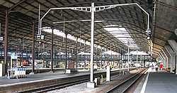
The line begins at Lucerne station, one of Switzerland's principal railway stations and which is shared with the standard gauge lines of the Swiss Federal Railways. Shortly after leaving the station, the line enters a tunnel under Lucerne's southern suburbs as far as Kriens Mattenhof station. From here the line runs on the surface to Hergiswil, where there is a junction with the Luzern–Stans–Engelberg line.[1][3]
The Lucerne to Hergiswil section of the Brünig line is double track, except for a short section north of Hergiswil. For much of the distance, one of the two tracks is dual gauge with the Swiss standard gauge freight line serving the industrial areas and the Eichhof brewery. Beyond Hergiswil the line is mainly single track except for passing loops at stations.[1]
From Hergiswil station the Brünig line runs through the Lopper I tunnel, under a shoulder of Mount Pilatus, to Alpnachstad, which is the starting point of the Pilatus railway. The two lines are of different gauges, and there is no track connection. From Alpnachstad station, the Brünig line follows the Sarner Aa river and Lake Sarner to Giswil.[1]
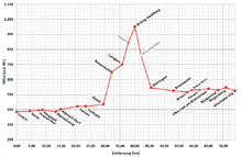
Beyond Giswil station, the line's first rack section then allows the line to climb to Kaiserstuhl station. From here, the runs through the upper basin of the Sarner Aa and alongside Lake Lungern as far as Lungern. This is the steepest adhesion worked section of the line, with a gradient of 3%.[1][3]
After Lungern station, a second rack section lifts the line to its summit at Brünig-Hasliberg station in the Brünig Pass. Beyond the pass, the line descends its third and final rack section, down the steep side of the valley of the Aar river, to Meiringen. This is the steepest section of the line, with a gradient of 12%.[1][3]
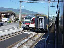
At Meiringen station, the Brünig line reverses direction with trains both entering and leaving the station from the west end. The Meiringen–Innertkirchen railway (MIB) connects here, leaving the station from its eastern end. Although there is a track connection between the two lines, they are electrically incompatible, and no through trains operate.[1]
From Meiringen to Brienz the line runs close to the Aar river, in that river's valley. At Brienz station, the starting point of the Brienz Rothorn railway is beside the Brünig railway station. The two lines are of different gauges, and there is no track connection. Beyond Brienz, the Brünig line runs along the northern shore of Lake Brienz, in a section often affected by landslides.[1]
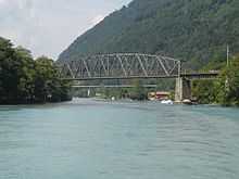
Finally the line crosses the Aar river on a high bridge, so built in order to allow lake shipping to reach Interlaken. It then passes over the standard gauge access to the BLS AG works at Bönigen, before descending into its terminus at Interlaken Ost station, which is shared with the BLS AG and Berner Oberland railway (BOB). There is a physical connection with the BOB, which is also metre gauge, but again the lines are electrically incompatible and no through trains operate.[1]
Stations
- Lucerne
- Lucerne Allmend/Messe
- Kriens Mattenhof
- Horw
- Hergiswil Matt
- Hergiswil
- Alpnachstad
- Alpnach Dorf
- Sarnen
- Sachseln
- Ewil Maxon
- Giswil
- Kaiserstuhl OW
- Lungern
- Brünig-Hasliberg
- Meiringen
- Brienzwiler
- Brienz
- Brienz West
- Ebligen
- Oberried am Brienzersee
- Niederried
- Ringgenberg
- Interlaken Ost
References
- ↑ 1.0 1.1 1.2 1.3 1.4 1.5 1.6 1.7 1.8 Eisenbahnatlas Schweiz. Verlag Schweers + Wall GmbH. 2012. pp. 22,33. ISBN 978-3-89494-130-7.
- ↑ 2.0 2.1 2.2 2.3 "Die Geschichte der Zentralbahn" (in German). Zentralbahn. Retrieved 2013-12-11.
- ↑ 3.0 3.1 3.2 3.3 3.4 3.5 Allen, Cecil J. (1958). Switzerland's Amazing Railways. London: Thomas Nelson and Sons. pp. 107–109.
- ↑ "Luzern–Brünig–Interlaken". Bundesamt für Verkehr. Retrieved 2013-01-07.
- ↑ Bärtschi, Hans-Peter. "Jura-Simplon-Bahn (JS)" (in German). Historischen Lexikon der Schweiz. Retrieved 2013-12-11.
- ↑ Peter Berger, Hans Waldburger and Christoph Berger (1998). Bahnen nach Engelberg. Luzern: Minirex. ISBN 3-907014-10-3.
- ↑ "Ausbau Zentralbahn" [Zentralbahn Expansion] (in German). Retrieved 2013-01-15.
- ↑ "Ausbau Zentralbahn - Ziele und Nutzen" [Zentralbahn Expansion - Objectives and Benefits] (in German). Retrieved 2013-01-15.
External links
![]() Media related to Brünigbahn at Wikimedia Commons
Media related to Brünigbahn at Wikimedia Commons