Brüggen, Germany
From Wikipedia, the free encyclopedia
| Brüggen | ||
|---|---|---|
| ||
 Brüggen | ||
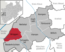
Location of Brüggen within Viersen district  | ||
| Coordinates: 51°14′30″N 06°10′56″E / 51.24167°N 6.18222°ECoordinates: 51°14′30″N 06°10′56″E / 51.24167°N 6.18222°E | ||
| Country | Germany | |
| State | North Rhine-Westphalia | |
| Admin. region | Düsseldorf | |
| District | Viersen | |
| Subdivisions | 3 | |
| Government | ||
| • Mayor | Gerhard Gottwald (CDU) | |
| Area | ||
| • Total | 61.25 km2 (23.65 sq mi) | |
| Elevation | 50 m (160 ft) | |
| Population (2012-12-31)[1] | ||
| • Total | 15,482 | |
| • Density | 250/km2 (650/sq mi) | |
| Time zone | CET/CEST (UTC+1/+2) | |
| Postal codes | 41379 | |
| Dialling codes |
0 21 63 0 21 57 (Bracht) | |
| Vehicle registration | VIE (until 1975: KK) | |
| Website | www.brueggen.de | |
Brüggen is a municipality in the district of Viersen, in North Rhine-Westphalia, Germany. It is situated near the border with the Netherlands, on the river Schwalm, approx. 15 km south of Venlo and 20 km north-west of Mönchengladbach.
Division of the town
Brüggen consists of 3 subdivisions
- Brüggen
- Born
- Bracht
Climate
Climate in this area has mild differences between highs and lows, and there is adequate rainfall year round. The Köppen Climate Classification subtype for this climate is "Cfb" (Marine West Coast Climate/Oceanic climate).[2]
| Climate data for Brüggen, Germany | |||||||||||||
|---|---|---|---|---|---|---|---|---|---|---|---|---|---|
| Month | Jan | Feb | Mar | Apr | May | Jun | Jul | Aug | Sep | Oct | Nov | Dec | Year |
| Average high °C (°F) | 4 (39) |
5 (41) |
9 (49) |
13 (56) |
17 (63) |
21 (69) |
22 (72) |
22 (71) |
19 (66) |
14 (58) |
8 (47) |
6 (42) |
13.3 (56.1) |
| Average low °C (°F) | 0 (32) |
−1 (31) |
2 (36) |
4 (40) |
8 (46) |
11 (52) |
13 (56) |
13 (55) |
11 (52) |
7 (45) |
4 (39) |
−18 (0) |
4.5 (40.3) |
| Precipitation mm (inches) | 64 (2.5) |
56 (2.2) |
43 (1.7) |
46 (1.8) |
64 (2.5) |
69 (2.7) |
84 (3.3) |
84 (3.3) |
80 (3) |
46 (1.8) |
64 (2.5) |
64 (2.5) |
764 (29.8) |
| Source: Weatherbase [3] | |||||||||||||
See also
Royal Air Force Station Brüggen
| |||||||
References
- ↑ "Amtliche Bevölkerungszahlen". Landesbetrieb Information und Technik NRW (in German). 31 July 2013.
- ↑ Climate Summary for Brüggen, Germany
- ↑ "Weatherbase.com". Weatherbase. 2013. Retrieved on July 26, 2013.
This article is issued from Wikipedia. The text is available under the Creative Commons Attribution/Share Alike; additional terms may apply for the media files.
