Bowdoin (MBTA station)
| BOWDOIN | |||||||||||
|---|---|---|---|---|---|---|---|---|---|---|---|
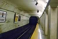
 Wedge-shaped island platform at Bowdoin station | |||||||||||
| Station statistics | |||||||||||
| Address | Cambridge Street at New Chardon and Bowdoin Streets, Boston | ||||||||||
| Coordinates | 42°21′41″N 71°03′44″W / 42.3614°N 71.0622°WCoordinates: 42°21′41″N 71°03′44″W / 42.3614°N 71.0622°W | ||||||||||
| Line(s) | |||||||||||
| Platforms | 1 Wedge shaped island platform | ||||||||||
| Tracks | 2 | ||||||||||
| Other information | |||||||||||
| Opened | March 18, 1916 | ||||||||||
| Owned by | Massachusetts Bay Transportation Authority | ||||||||||
| Traffic | |||||||||||
| Passengers (2009) | 1,454 (weekday average boardings)[1] | ||||||||||
| Services | |||||||||||
| |||||||||||
Bowdoin (pronounced BO-din) of the MBTA, is a station on the Blue Line, serving Bowdoin Square in Boston's Beacon Hill neighborhood. It is currently the downtown terminus of the line, although it may close if the line is extended or after Government Center is rebuilt.
History


Bowdoin station opened for service on March 18, 1916 as the terminus of the East Boston Tunnel, connecting Beacon Hill to Maverick Square. Along with Government Center, it replaced Court Street Station as the turnaround point for trolley cars from East Boston. The line was converted to heavy rail metro cars in 1925, and the loop has been a tight fit for rapid transit cars ever since. Blue Line cars are 48 feet long, shorter than the 65-foot Orange Line and 69-foot Red Line cars,[2] partially because of the tight loop. Bowdoin is the only remaining turnaround loop on the MBTA's heavy rail lines; Wonderland and all Orange and Red Line termini simply use crossovers to reverse the direction of trains.
Current status
The station is lightly used except at rush hour. Prior to December 28, 2013, Bowdoin station was only open from 5:15AM to 6:30PM, Monday through Friday, excluding holidays. At all other times, trains terminated and originated service at Government Center station. The tight loop just past the station is used to turn around Blue Line trains at all times, sending them back to Government Center and onwards to Wonderland, in Revere. The platform is wedge shaped, with a single entrance at the wide end near the turnaround loop.
In 2008, the MBTA started running a mixture of 4-car and 6-car trains on the Blue Line, adding more long trains as new cars arrive from the manufacturer. Incoming 6-car trains can fit on the westbound platform where trains go out of service, but only 4-car trains can fit on the eastbound side where trains come into service after turning around. At Bowdoin only, passenger must press a "door open" button outside of the train to board a 6-car train.
Bowdoin station is currently open for all hours of service, including on weekends, from December 28, 2013 and continuing during the closure of the Callahan Tunnel and the subsequent closure of Government Center Station in Spring 2014.[3][4]
Future
Bowdoin is slated to be closed once the Government Center renovation is complete, due to the short distance between the lengthened platforms. A second headhouse might be added to Government Center closer to Bowdoin Station on Cambridge Street. This would reduce the walking distance from 980 to 575 feet.[5] Bowdoin will likely continue to be used as a turnaround loop, unless the proposed Blue Line extension tunnel to Charles/MGH is constructed.[6][7]
Station layout
| G | Street Level | Exit/Entrance |
| M | Mezzanine | Fare control and lobby |
| P Platform level |
Southbound | ← Blue Line termination platform (fits 6 cars) |
| Northbound | → Blue Line toward Wonderland (Government Center, fits 4 cars) | |
References
- ↑ "Ridership and Service Statistics". Massachusetts Bay Transportation Authority. 2010. Retrieved October 28, 2012.
- ↑ "The MBTA Vehicle Inventory page". Retrieved 1 October 2011.
- ↑ "CALLAHAN TUNNEL CLOSES FRIDAY NIGHT at 11pm". Massachusetts Bay Transportation Authority. 23 December 2013. Archived from the original on 29 December 2013. Retrieved 29 December 2013.
- ↑ http://www.mbta.com/riding_the_t/default.asp?id=26899
- ↑ Bowdoin Street station to close in three years by Jaclyn Trop. Beacon Hill Times, 24 Oct 2006.
- ↑ "Red Line Blue Line Connector". Mass.gov. Commonwealth of Massachusetts. Retrieved 2011-07-27.
- ↑ "Red Line Blue Line Connector Factsheet". Mass.gov. Commonwealth of Massachusetts. Retrieved 2011-07-27.
External links
| Wikimedia Commons has media related to Bowdoin (MBTA station). |
| ||||||||||||||||||||||