Bourbre
From Wikipedia, the free encyclopedia
| Bourbre | |
|---|---|
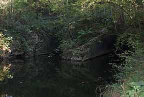 The Bourbre at La Bâtie-Montgascon | |
| Origin |
Burcin 45°25′57″N 05°25′56″E / 45.43250°N 5.43222°E |
| Mouth |
Rhone 45°46′25″N 05°11′15″E / 45.77361°N 5.18750°ECoordinates: 45°46′25″N 05°11′15″E / 45.77361°N 5.18750°E |
| Basin countries | France |
| Length | 72.2 km (44.9 mi) |
| Source elevation | 495 m (1,624 ft) |
| Mouth elevation | 190 m (620 ft) |
| Avg. discharge | 7.85 m3/s (277 cu ft/s) at mouth |
| Basin area | 703 km2 (271 sq mi) |
The Bourbre (French: la Bourbre) is a 72.2 km (44.9 mi) long river in the Isère and Rhône départements, central eastern France. Its source is in Burcin. It flows generally north-northwest. It is a left tributary of the Rhone into which it flows at Chavanoz.
Départements and communes along its course
This list is ordered from source to mouth:
- Isère: Burcin, Châbons, Virieu, Blandin, Panissage, Chélieu, Chassignieu, Le Passage, Saint-Ondras, Saint-André-le-Gaz, Fitilieu, La Bâtie-Montgascon, Saint-Didier-de-la-Tour, Saint-Clair-de-la-Tour, La Tour-du-Pin, Saint-Jean-de-Soudain, Rochetoirin, Cessieu, Sérézin-de-la-Tour, Ruy, Nivolas-Vermelle, Bourgoin-Jallieu, L'Isle-d'Abeau, Vaulx-Milieu, Villefontaine, La Verpillière, Saint-Quentin-Fallavier, Chamagnieu, Satolas-et-Bonce
- Rhône: Colombier-Saugnieu
- Isère: Tignieu-Jameyzieu, Charvieu-Chavagneux, Pont-de-Chéruy, Chavanoz,
Notes
- This article incorporates information from this version of the equivalent article on the French Wikipedia.
References
| Wikimedia Commons has media related to Bourbre. |
This article is issued from Wikipedia. The text is available under the Creative Commons Attribution/Share Alike; additional terms may apply for the media files.