Boundary Islet
Boundary Islet straddles the border of the Australian states of Victoria and Tasmania.
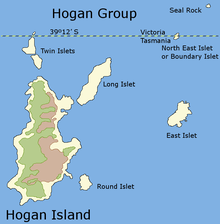
It is an islet of under two hectares (4.9 acres) in the Hogan Group of islands and islets. It is located at latitude 39°12' S, approximately 56 kilometres (35 mi) east of the southernmost part of mainland Victoria. The boundary between Victoria and Tasmania is a parallel similarly at latitude 39°12'. Thus, the islet is Tasmania's only land boundary, and at 85 metres (279 ft) long, it is the shortest land border between any Australian state or territory.[1]
The position of the island was surveyed in 1801 by Captain James Black, who erred in placing the islet further north than it is. It was later found that the border at 39°12' S actually passed through the islet.
Boundary Islet was once known as North East Islet.
References
- ↑ Jacobs, Frank (April 24, 2012). "One Island, Two Countries". The New York Times.
External links
Coordinates: 39°11′55″S 147°1′17″E / 39.19861°S 147.02139°E