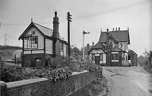
Bosley railway station
| Bosley | |
|---|---|
 | |
| Bosley station in 1963 | |
| Location | |
| Place | Bosley, Cheshire |
| Area | Cheshire East |
| Grid reference | SJ913651 |
| Operations | |
| Post-grouping |
London, Midland and Scottish Railway London Midland Region of British Railways |
| Platforms | 2 |
| History | |
| 1 September 1849 | Opened[1] |
| 7 November 1960 | Closed to passengers[1] |
| 15 June 1964 | Closed to freight |
| Disused railway stations in the United Kingdom | |
|
Closed railway stations in Britain A B C D–F G H–J K–L M–O P–R S T–V W–Z | |
|
| |
Bosley railway station served the village of Bosley, Cheshire. The station was opened by the North Staffordshire Railway in September 1849[nb 1] as part of the Churnet Valley line.[2]
The station was some distance from the village which is was linked to by a footpath. To travel between the village and the station by road was a much longer journey. The main customer of the station was the corn mill belonging to Francis R Thompstone & Sons Ltd which was situated next to the station. Thompstones also had their own 2 ft 6 in (762 mm) tramway which ran for 0.75 miles (1.21 km) from the mill to the Macclesfield Canal and was used for transporting corn from the canal to the mill. The tramway opened in 1887 and closed around 1925. Remains of the track can still just be seen in a shallow cutting through woodland, leading to the old transhipment dock, just below Bosley bottom lock.[2]
Bosley station remained open until passenger services were withdrawn from the northern end of the Churnet valley line (North Rode – Leek) in 1960.[3] Freight services lasted until 1964 when they too were withdrawn and the track lifted.[3]
Route
| Preceding station | Historical railways | Following station | ||
|---|---|---|---|---|
| North Rode | North Staffordshire Railway Churnet Valley Line |
Rushton | ||
References
- Notes
- Footnotes
- Sources
- Christiansen, Rex; Miller, Robert William (1971). The North Staffordshire Railway. Newton Abbot, Devon: David & Charles. ISBN 0-7153-5121-4.
- Jeuda, Basil (1999). The Churnet Valley Railway. Lydney, Gloucestershire: Lightmoor Press. ISBN 978-1-899889-05-1.
- Quick, Michael (2009) [2001]. Railway passenger stations in Great Britain: a chronology (4th ed.). Oxford: Railway and Canal Historical Society. ISBN 978 0 901461 57 5. OCLC 612226077.
Coordinates: 53°10′59″N 2°07′54″W / 53.18317°N 2.13155°W
| |||||||||||||||||||||||||||||||||||||||||||||||