Bolivar Peninsula, Texas
| Bolivar Peninsula, Texas | |
|---|---|
| CDP | |
 | |
| Coordinates: 29°27′52″N 94°36′28″W / 29.46444°N 94.60778°WCoordinates: 29°27′52″N 94°36′28″W / 29.46444°N 94.60778°W | |
| Country | United States |
| State | Texas |
| County | Galveston |
| Area | |
| • Total | 48.1 sq mi (124.7 km2) |
| • Land | 42.5 sq mi (110.1 km2) |
| • Water | 5.6 sq mi (14.6 km2) |
| Elevation | 10 ft (3 m) |
| Population (2010) | |
| • Total | 2,417 |
| • Density | 50/sq mi (19/km2) |
| Time zone | Central (CST) (UTC-6) |
| • Summer (DST) | CDT (UTC-5) |
| FIPS code | 48-09250[1] |
| GNIS feature ID | 1852688[2] |
Bolivar Peninsula is a census-designated place (CDP) in Galveston County, Texas, United States. The population was 2,417 at the 2010 census.[3] The communities of Port Bolivar, Crystal Beach, Caplen, Gilchrist, and High Island are located on Bolivar Peninsula.
History
The peninsula was named by 1816 for Simón Bolívar,[4] a South American political leader. Jean Laffite had associations with Bolivar Peninsula.[5] James Long based his operations here since 1819 with the first establishment of Bolivar Peninsula,[6] and Fort Las Casas was built here in 1820.[5] Samuel D. Parr is responsible for starting the settlement in 1838 that would later become Port Bolivar.[5]
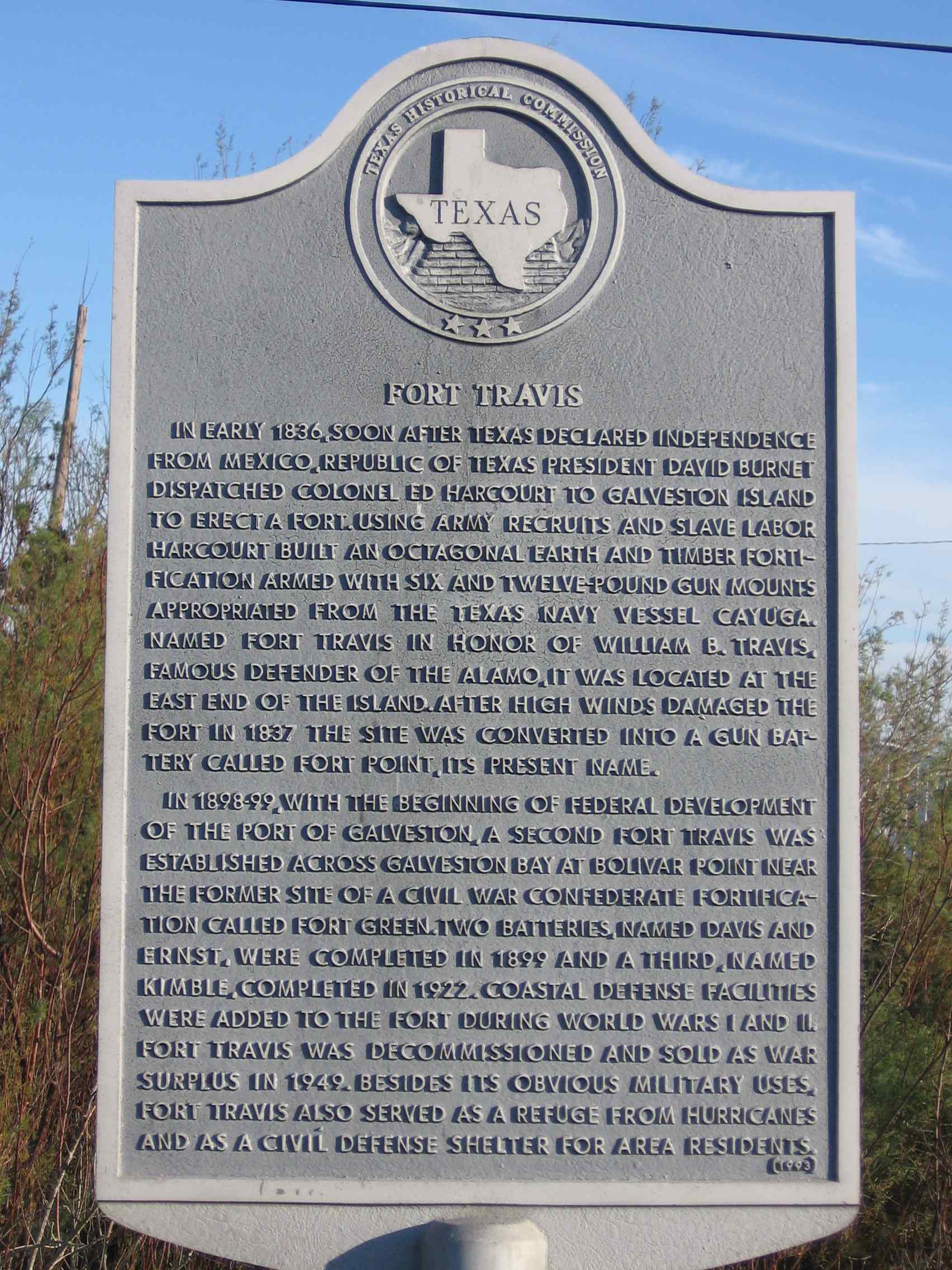
The Point Bolivar Lighthouse (which is now privately owned and not open to the public) has an important history with the peninsula, since 1872. It is located on the western end of the peninsula, directly across from Fort Travis Seashore Park. Fort Travis in Bolivar Peninsula, a separate facility from Fort Travis in Galveston, was built with construction started in 1898.[7][8] The North Jetty, extending from Bolivar Peninsula, of the entrance to Galveston Bay started being constructed in 1874.[5] From 1896 to 1968, the Gulf and Interstate Railway connected Beaumont to Galveston Island with aid of train ferries.[7] At one time the Bolivar Peninsula was called the "breadbasket of Galveston" and the "watermelon capital of Texas".[5]
Crystal Beach was incorporated from 1971 until 1987, and it has been the most populated community of the Bolivar Peninsula.[9] On April 23, 1991, communities of Bolivar Peninsula received an enhanced 9-1-1 system which routes calls to proper dispatchers and allows dispatchers to automatically view the address of the caller.[10] The Bolivar Peninsula suffered heavy damage from Hurricane Ike that made landfall on the Texas coast on September 13, 2008.
Geography

The Bolivar Peninsula forms a very narrow strip of land in Galveston County, Texas, separating the eastern part of Galveston Bay from the Gulf of Mexico. Its narrowest point is a quarter of a mile and is near the unincorporated community of Gilchrist, where the peninsula is divided by the man-made Rollover Pass.
According to the United States Census Bureau, the CDP has a total area of 48.1 square miles (124.7 km2), of which 42.5 square miles (110.1 km2) is land and 5.6 square miles (14.6 km2), or 11.7%, is water.[11]
Demographics
- Note: Information prior to September 2008's Hurricane Ike may be significantly different than current information.
As of the census[1] of 2000, there were 3,853 people, 1,801 households, and 1,138 families residing in the CDP. The population density was 85.3 people per square mile (32.9/km²). There were 5,425 housing units at an average density of 120.0 per square mile (46.4/km²). The racial makeup of the CDP was 93.69% White, 0.47% African American, 0.80% Native American, 0.57% Asian, 2.80% from other races, and 1.66% from two or more races. Hispanic or Latino of any race were 6.96% of the population.
There were 1,801 households out of which 18.0% had children under the age of 18 living with them, 52.3% were married couples living together, 7.4% had a female householder with no husband present, and 36.8% were non-families. 31.3% of all households were made up of individuals and 12.9% had someone living alone who was 65 years of age or older. The average household size was 2.14 and the average family size was 2.65.
In the CDP the population was spread out with 17.0% under the age of 18, 5.6% from 18 to 24, 20.7% from 25 to 44, 35.1% from 45 to 64, and 21.6% who were 65 years of age or older. The median age was 48 years. For every 100 females there were 104.4 males. For every 100 females age 18 and over, there were 104.1 males.
The median income for a household in the CDP was $34,235, and the median income for a family was $42,448. Males had a median income of $36,477 versus $24,519 for females. The per capita income for the CDP was $26,137. About 8.3% of families and 11.7% of the population were below the poverty line, including 13.4% of those under age 18 and 7.3% of those age 65 or over.
Education
Bolivar Peninsula residents are divided between the Galveston Independent School District and the High Island Independent School District.
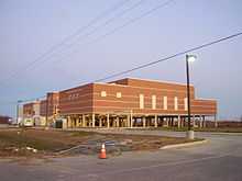
The western portion of the Bolivar Peninsula, including the unincorporated communities of Port Bolivar and Crystal Beach, are within the Galveston Independent School District. That portion is served by the Pre-K-8 Crenshaw Elementary and Middle School, located on the peninsula, and Ball High School (9-12), located on the island of Galveston. The current Crenshaw building opened in 2005.[12]
The eastern portion of the peninsula, including the unincorporated communities of Caplen, Gilchrist, and High Island, is served by the High Island Independent School District.
Galveston College serves all of the Bolivar Peninsula.[13]
Parks and recreation
The Galveston County Department of Parks and Senior Services operates the Joe Faggard Community Center at 1760 State Highway 87 in the Crystal Beach area.[14]
The community holds a Mardi Gras celebration along Texas State Highway 87 each year. Many people and groups, including beach bars, politicians, and school groups have krewes in the celebration. Brittanie Shey of the Houston Press described the celebration as a "small town parade."[15]
Transportation
The Texas Department of Transportation provides ferry service from Port Bolivar at the western end of the Bolivar Peninsula to Galveston. During the non-tourist season, there is only a tentative daily schedule for this service, running approximately every thirty minutes from either side during daylight hours and once an hour after nightfall. Boats will depart the landing from any given side on the captain's prerogative. During tourist season and on occasion of holiday weekends and large events on the island of Galveston (only) the boats have been known to run as quickly as every fifteen minutes departing both sides every twenty minutes at most. On these occasions, the ferry service may have as many as five boats in the water, compared to three during the off-season. There was a proposal to build the Bolivar Bridge to connect Galveston Island to Bolivar Peninsula, but it has been canceled.[16]
Crime
A Bolivar Peninsula woman quoted in the Houston Chronicle, said "There's a lot of drugs and drinking. In the summer time at the Fourth of July and stuff, it's bad."[17] She said that she would like to see the county sheriff add patrols on the Bolivar Peninsula but she argued that the area to patrol would be too big and so the county cannot control the crime.[17]
Hurricane Ike
.JPG)
At 7:10 UST on September 13, 2008 (2:10 AM local), Hurricane Ike made landfall at the east end of Galveston Island, Texas as the largest North Atlantic hurricane in recorded history.[18] At the height of the storm, Ike’s cloud mass essentially covered the entire Gulf of Mexico. The Wind and Surge Destructive Potential Classification Scale, which was detailed in Tropical Cyclone Destructive Potential by Integrated Kinetic Energy (by Dr. Mark Powell and Dr. Tim Reinhold, April 2007) offers a new way to assess hurricane size and strength by calculating the total kinetic energy contained in a 1-meter deep horizontal slice of the storm at an elevation of 10 meters above the land or ocean surface. Using this type of calculation, the integrated kinetic energy was calculated for Ike and was found to be 25 percent greater than the comparable maximum estimate for Hurricane Katrina in 2005.[19][20]
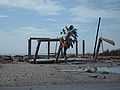
Hurricane Ike caused cataclysmic destruction of the peninsula, reducing the region to rubble and causing severe, permanent change in the shoreline. Entire communities along the upper Texas coast were simply wiped out by Ike’s catastrophic storm surge.[21] Ike’s effects were disproportionally felt near the long, low-lying Bolivar Peninsula which has typical elevations around 2 m. Despite being only a strong category 2 storm with maximum winds at landfall of 95 knots (49 m/s, Berg, 2009), Ike’s extremely large, long-lasting surge and waves devastated the peninsula.[20] In Gilchrist, Texas, NOAA aerial photography reveals complete destruction. The roll-over pass bridge was reduced to one lane. Of the 1,000 buildings in Gilchrist, 99.5% of them were knocked off of their foundations. Of the buildings off of the foundations, the storm demolished some and washed others onto swamplands behind Gilchrist.[22]
The Bolivar Peninsula was just to the right of landfall, placing it on the strong side of the hurricane. H Wind reconstructions (Powell et al., 1998) show winds blowing strongly from offshore-to-onshore for most of the storm, which acted to increase both surge and waves. Surge is extremely important for the particular case of the Bolivar Peninsula, as it allowed large waves to penetrate inland into areas they could not otherwise have reached. Shoreline erosion was around 75 m, which undermined the piled foundations of oceanfront buildings.[23] Most other houses in this area were reduced to either piles or slabs by large waves riding on surge, with only a very few remaining more or less intact. Peak coastal surges reached 21-foot (6.4 m). Water depths of at least 5-foot (1.5 m) covered all of the Bolivar Peninsula, with most areas covered by at least 15-foot (4.6 m) of water (not including wave action).[24] Much of the southern part of Chambers County was also inundated by at least 12-foot (3.7 m) of water. According to post-storm analyses by both the National Oceanic and Atmospheric Administration’s (NOAA) Hurricane Research Division and Applied Research Associates (ARA), a research and engineering company, the best estimates of 3-second peak wind gusts along the eastern portion of the peninsula were between 110 mph and 115 mph. Research observations also suggest most of eastern and southeastern Texas was subjected to tropical storm and hurricane-force winds for ten hours, and possibly longer.[25][26]
Cindy Horswell of McClatchy - Tribune Business News said that authorities said that 3,600 structures on the peninsula, 62% of them, were destroyed or severely damaged by Ike's storm surge.[27] By January 2009, 40% of Bolivar Peninsula's population had returned. Of the Bolivar Peninsula communities, Gilchrist received the fewest returnees.[27]
Bolivar Peninsula After Ike
.JPG)


.jpg)
.jpg)
.jpg)
.jpg)
.JPG)
.jpg)
Government and infrastructure
The United States Postal Service once operated the Gilchrist Post Office, which opened on September 16, 1950. It closed on July 31, 2010.[28]
References
- ↑ 1.0 1.1 "American FactFinder". United States Census Bureau. Retrieved 2008-01-31.
- ↑ "US Board on Geographic Names". United States Geological Survey. 2007-10-25. Retrieved 2008-01-31.
- ↑ "Profile of General Population and Housing Characteristics: 2010 Demographic Profile Data (DP-1): Bolivar Peninsula CDP, Texas". U.S. Census Bureau, American Factfinder. Retrieved January 11, 2012.
- ↑ http://www.tshaonline.org/handbook/online/articles/rrb06
- ↑ 5.0 5.1 5.2 5.3 5.4 "BOLIVAR PENINSULA". Handbook of Texas Online. Texas State Historical Association. Retrieved 2013-06-12.
- ↑ A. Pat Daniels. "PORT BOLIVAR, TX". Handbook of Texas Online. Texas State Historical Association. Retrieved 2013-06-11.
- ↑ 7.0 7.1 "Fort Travis". Texas Historical Commission. Retrieved 2013-06-11.
- ↑ Wooster, Robert. "GULF AND INTER-STATE RAILWAY". Handbook of Texas Online. Texas State Historical Association. Retrieved 2013-06-11.
- ↑ Daniels, Pat. "Crystal Beach, TX". The Handbook of Texas Online. Texas State Historical Association. Retrieved 2013-06-12.
- ↑ "News briefs." Houston Chronicle. Tuesday April 23, 1991. A14.
- ↑ "Geographic Identifiers: 2010 Demographic Profile Data (G001): Bolivar Peninsula CDP, Texas". U.S. Census Bureau, American Factfinder. Retrieved January 11, 2012.
- ↑ "Crenshaw School Profile." Galveston Independent School District. Retrieved on November 30, 2008.
- ↑ Texas Education Code, Section 130.179, "Galveston College District Service Area".
- ↑ Facilities Overview." Galveston County Department of Parks and Senior Services.
- ↑ Shey, Brittanie. "Texas Traveler: Bolivar Mardi Gras." Houston Press. Tuesday February 16, 2010. Retrieved on February 18, 2010.
- ↑ "Bolivar Bridge Goes Nowhere". Galveston County - The Daily News. July 8, 2007. Retrieved 2013-06-12.
- ↑ 17.0 17.1 Evans, Thayer. "Crime numbers go down - Figures drop 26.4 percent in unincorporated Galveston County." Houston Chronicle. Thursday February 3, 2005. ThisWeek p. 1. Available at NewsBank Record Number: 3841079. "Even though Womble would like to see extra patrols on the peninsula, she doesn't blame the sheriff's office for the crimes that are being committed. "They can't control it," she said. "The beach is too big." "
- ↑ NOAA - National Climatic Data Center (U.S. Department of Commerce)
- ↑ Ike Wind and Surge Destructive Potential
- ↑ 20.0 20.1 [www.eenews.net/public/25/12353/features/.../09/.../document_cw_01.pdf Destruction of the Peninsula]
- ↑ Houston Weather: Ike's Aftermath
- ↑ Connelly, Richard. "Goodbye, Gilchrist." Houston Press. September 17, 2008.
- ↑ Damage, Erosion from Ike
- ↑ NOAA Info Center
- ↑ Ike Technical Report
- ↑ Waves, Surge and Damage on the Bolivar Peninsula During Hurricane Ike
- ↑ 27.0 27.1 Horswell, Cindy. "Holes left in wake of storms: Ike hit before some Texas communities recovered from Rita." McClatchy - Tribune Business News. January 19, 2009. Available at ProQuest, document ID 456273366
- ↑ "Postmaster Finder Post Offices by Discontinued Date." United States Postal Service. Retrieved on September 23, 2010. "07/31/2010 GILCHRIST TX GALVESTON COUNTY 77617 09/16/1950"
External links
- Bolivar Chamber of Commerce
- "Bolivar Peninsula", Handbook of Texas Online
- "Bolivar Peninsula, TX" at City-data.com
- "Confusion Rules Road in and Out of Galveston", The New York Times, Sept. 17, 2008
- "Waste Land, Texas", WABC, Sept. 18, 2008
| |||||||||||||||||||||||
