Bodega, California
| Bodega Bodega Corners | |
|---|---|
| census-designated place & unincorporated community | |
 | |
 Bodega | |
| Coordinates: 38°20′43″N 122°58′26″W / 38.34528°N 122.97389°WCoordinates: 38°20′43″N 122°58′26″W / 38.34528°N 122.97389°W | |
| Country |
|
| State |
|
| County | Sonoma |
| Area[1] | |
| • Total | 2.902 sq mi (7.516 km2) |
| • Land | 2.902 sq mi (7.516 km2) |
| • Water | 0 sq mi (0 km2) 0% |
| Elevation[2] | 118 ft (36 m) |
| Population (2010) | |
| • Total | 220 |
| • Density | 76/sq mi (29/km2) |
| Time zone | PST (UTC-8) |
| • Summer (DST) | PDT (UTC-7) |
| ZIP code | 94922 |
| Area code(s) | 707 |
| FIPS code | 06-07246 |
| GNIS feature ID | 219574 |
| Website | http://bodegacalifornia.com/ |
Bodega is an unincorporated community and census-designated place (CDP) in Sonoma County in the U.S. state of California. The town had a population of 220 as of the 2010 Census.
Bodega is located on Bodega Highway, about 5 mi (8 km) west of Freestone, California. Salmon Creek flows through the town.
History

There were formerly two Coast Miwok villages in the area: one (called Kennekono) sited near the current town and another (called Suwutenne) further north.[3]
In 1843, Captain Stephen Smith established the first West Coast lumber mill near Bodega. In 1859, shipbuilders constructed Saint Teresa of Avila Church, which later appeared in Alfred Hitchcock's film, The Birds.
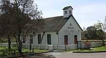
Open from 1856 to 1967, Watson School, once served as Bodega's school, and is located in a Sonoma County Regional Parks Department historic park about 2 miles east of Bodega.
Environment
Government
In the state legislature, Bodega is in the 2nd Senate District and the 1st Assembly District.
Federally, Bodega Bay is in California's 2nd congressional district, represented by Democrat Jared Huffman.[4]
At the county level, Bodega is in Sonoma County's 5th supervisorial district.[5]
Education
Transportation
The main road through town is Bodega Highway, which runs east to Freestone and Sebastopol and south to State Route 1 less than a mile (1.6 km) away. State Route 1 provides access to the neighboring towns of Bodega Bay and Valley Ford.
The Mendocino Transit Authority provides bus service to Bodega. Routes 75 and 95 stop at Bodega two times a day. An eastbound one at 10:25 am, and the same one returning westbound at 4:55 pm.[6]
Geography
According to the United States Census Bureau, the CDP covers an area of 2.9 square miles (7.5 km²), all of it land.
Demographics
The 2010 United States Census[7] reported that Bodega had a population of 220. The population density was 75.8 people per square mile (29.3/km²). The racial makeup of Bodega was 209 (95.0%) White, 0 (0.0%) African American, 2 (0.9%) Native American, 2 (0.9%) Asian, 0 (0.0%) Pacific Islander, 0 (0.0%) from other races, and 7 (3.2%) from two or more races. Hispanic or Latino of any race were 9 persons (4.1%).
The Census reported that 220 people (100% of the population) lived in households, 0 (0%) lived in non-institutionalized group quarters, and 0 (0%) were institutionalized.
There were 117 households, out of which 16 (13.7%) had children under the age of 18 living in them, 43 (36.8%) were opposite-sex married couples living together, 5 (4.3%) had a female householder with no husband present, 7 (6.0%) had a male householder with no wife present. There were 9 (7.7%) unmarried opposite-sex partnerships, and 1 (0.9%) same-sex married couples or partnerships. 51 households (43.6%) were made up of individuals and 13 (11.1%) had someone living alone who was 65 years of age or older. The average household size was 1.88. There were 55 families (47.0% of all households); the average family size was 2.55.
The population was spread out with 25 people (11.4%) under the age of 18, 12 people (5.5%) aged 18 to 24, 43 people (19.5%) aged 25 to 44, 101 people (45.9%) aged 45 to 64, and 39 people (17.7%) who were 65 years of age or older. The median age was 54.5 years. For every 100 females there were 94.7 males. For every 100 females age 18 and over, there were 101.0 males.
There were 131 housing units at an average density of 45.1 per square mile (17.4/km²), of which 66 (56.4%) were owner-occupied, and 51 (43.6%) were occupied by renters. The homeowner vacancy rate was 1.5%; the rental vacancy rate was 0%. 137 people (62.3% of the population) lived in owner-occupied housing units and 83 people (37.7%) lived in rental housing units.
See also
- Bodega Bay, California
- West coast lumber trade
Economy
References
- ↑ U.S. Census
- ↑ U.S. Geological Survey Geographic Names Information System: Bodega
- ↑ "Access Genealogy: Miwok Indian Tribe".
- ↑ "California's 2nd Congressional District - Representatives & District Map". Civic Impulse, LLC. Retrieved March 1, 2013.
- ↑ "Supervisorial Districts - Sonoma County - 2002". 2008-10-15.
- ↑ "South Mendocino Coast Bus Routes". Retrieved 2008-10-15.
- ↑ All data are derived from the United States Census Bureau reports from the 2010 United States Census, and are accessible on-line here. The data on unmarried partnerships and same-sex married couples are from the Census report DEC_10_SF1_PCT15. All other housing and population data are from Census report DEC_10_DP_DPDP1. Both reports are viewable online or downloadable in a zip file containing a comma-delimited data file. The area data, from which densities are calculated, are available on-line here. Percentage totals may not add to 100% due to rounding. The Census Bureau defines families as a household containing one or more people related to the householder by birth, opposite-sex marriage, or adoption. People living in group quarters are tabulated by the Census Bureau as neither owners nor renters. For further details, see the text files accompanying the data files containing the Census reports mentioned above.
External links
| ||||||||||||||||||||
| ||||||||||||||||||||||||||||||||
 |
Bodega Bay | Occidental |  | |
| Doran Regional Park | |
Freestone | ||
| ||||
| | ||||
| Estero Americano | Valley Ford |

