Blymhill
From Wikipedia, the free encyclopedia
Coordinates: 52°42′04″N 2°17′01″W / 52.7011°N 2.2836°W
| Blymhill | |
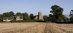
 View of Blymhill from the north showing the old school (left) and church (right). |
|
 A similar view in winter. |
|
 Blymhill | |
| OS grid reference | SJ808121 |
|---|---|
| Civil parish | Blymhill and Weston-under-Lizard |
| District | South Staffordshire |
| Shire county | Staffordshire |
| Region | West Midlands |
| Country | England |
| Sovereign state | United Kingdom |
| Post town | Shifnal |
| Postcode district | TF11 |
| Dialling code | 01952 |
| Police | Staffordshire |
| Fire | Staffordshire |
| Ambulance | West Midlands |
| EU Parliament | West Midlands |
| UK Parliament | Stafford |
| |
Blymhill is a village in Staffordshire, England.
See also
External links
![]() Media related to Blymhill at Wikimedia Commons
Media related to Blymhill at Wikimedia Commons
This article is issued from Wikipedia. The text is available under the Creative Commons Attribution/Share Alike; additional terms may apply for the media files.