Blue River (Missouri)
| Blue River | |
| Big Blue River | |
| River | |
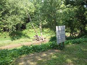
 Blue River at Byram's Ford where the Battle of Byram's Ford (a skirmish of the Battle of Westport) was fought by Swope Park | |
| Country | United States |
|---|---|
| States | Kansas, Missouri |
| Part of | Missouri River |
| Tributaries | |
| - left | Brush Creek (Blue River) |
| City | Kansas City |
| Source | |
| - location | East Johnson County, Kansas, United States |
| - elevation | 725 ft (221 m) |
| - coordinates | 38°48′31″N 094°40′50″W / 38.80861°N 94.68056°W [1] |
| Mouth | Missouri River |
| - location | Kansas City, Missouri, United States |
| - elevation | 221 ft (67 m) [1] |
| - coordinates | 39°07′48″N 094°28′15″W / 39.13000°N 94.47083°W [1] |
| Length | 39 mi (63 km), Northeast [2] |
 Blue River in the Kansas City metropolitan area
| |
The Blue River (also known as the Big Blue River) is a 39.8-mile-long (64.1 km)[2] stream that flows through Johnson County, Kansas and Jackson County, Missouri in the Kansas City Metropolitan Area. The river rises in Johnson County near the border of the states of Kansas and Missouri. Crossing the city of Kansas City, Missouri, it empties into the Missouri River near the border between Kansas City and Independence, Missouri.
One of its major tributaries is Brush Creek.
Mountain bike trails
The Blue River has mountain bike trails running along it parallel to Holmes Road in southern Kansas City, Missouri. These trails are located in the Red Bridge area and attract casual and hardcore bikers. The trails are believed to be located on what used to be a dirt race track, and in some places along the trail there remain concrete foundations. Motor vehicles are not allowed due to the fear of a fire started by sparks from an exhaust system.
See also
- Blue River (disambiguation)
- List of Kansas rivers
- List of Missouri rivers
References
- ↑ 1.0 1.1 1.2 "Blue River". Geographic Names Information System, U.S. Geological Survey. 1978-10-13. Retrieved 2013-08-17.
- ↑ 2.0 2.1 U.S. Geological Survey. National Hydrography Dataset high-resolution flowline data. The National Map, accessed May 31, 2011