Blue Line (Minnesota)
| METRO Blue Line | ||||||||||||||||||||||||||||||||||||||||||||||||||||||||||||||||||||||||||||||||||||||||||||||||||||||||||||||||||||||||||||||||||||||||||||||||||||||||||||||||||||||||||||||||||||||||||||||||||||||||||||||||||||||||||||||||||||||||||||||||||||||||
|---|---|---|---|---|---|---|---|---|---|---|---|---|---|---|---|---|---|---|---|---|---|---|---|---|---|---|---|---|---|---|---|---|---|---|---|---|---|---|---|---|---|---|---|---|---|---|---|---|---|---|---|---|---|---|---|---|---|---|---|---|---|---|---|---|---|---|---|---|---|---|---|---|---|---|---|---|---|---|---|---|---|---|---|---|---|---|---|---|---|---|---|---|---|---|---|---|---|---|---|---|---|---|---|---|---|---|---|---|---|---|---|---|---|---|---|---|---|---|---|---|---|---|---|---|---|---|---|---|---|---|---|---|---|---|---|---|---|---|---|---|---|---|---|---|---|---|---|---|---|---|---|---|---|---|---|---|---|---|---|---|---|---|---|---|---|---|---|---|---|---|---|---|---|---|---|---|---|---|---|---|---|---|---|---|---|---|---|---|---|---|---|---|---|---|---|---|---|---|---|---|---|---|---|---|---|---|---|---|---|---|---|---|---|---|---|---|---|---|---|---|---|---|---|---|---|---|---|---|---|---|---|---|---|---|---|---|---|---|---|---|---|---|---|---|---|---|---|---|
 Light rail train in Minneapolis | ||||||||||||||||||||||||||||||||||||||||||||||||||||||||||||||||||||||||||||||||||||||||||||||||||||||||||||||||||||||||||||||||||||||||||||||||||||||||||||||||||||||||||||||||||||||||||||||||||||||||||||||||||||||||||||||||||||||||||||||||||||||||
| Overview | ||||||||||||||||||||||||||||||||||||||||||||||||||||||||||||||||||||||||||||||||||||||||||||||||||||||||||||||||||||||||||||||||||||||||||||||||||||||||||||||||||||||||||||||||||||||||||||||||||||||||||||||||||||||||||||||||||||||||||||||||||||||||
| Type | Light rail | |||||||||||||||||||||||||||||||||||||||||||||||||||||||||||||||||||||||||||||||||||||||||||||||||||||||||||||||||||||||||||||||||||||||||||||||||||||||||||||||||||||||||||||||||||||||||||||||||||||||||||||||||||||||||||||||||||||||||||||||||||||||
| System | METRO | |||||||||||||||||||||||||||||||||||||||||||||||||||||||||||||||||||||||||||||||||||||||||||||||||||||||||||||||||||||||||||||||||||||||||||||||||||||||||||||||||||||||||||||||||||||||||||||||||||||||||||||||||||||||||||||||||||||||||||||||||||||||
| Status | Operational | |||||||||||||||||||||||||||||||||||||||||||||||||||||||||||||||||||||||||||||||||||||||||||||||||||||||||||||||||||||||||||||||||||||||||||||||||||||||||||||||||||||||||||||||||||||||||||||||||||||||||||||||||||||||||||||||||||||||||||||||||||||||
| Locale | Minneapolis–St. Paul metropolitan: Minneapolis, Minnesota, Fort Snelling, Minnesota, Minneapolis–Saint Paul International Airport, Bloomington, Minnesota | |||||||||||||||||||||||||||||||||||||||||||||||||||||||||||||||||||||||||||||||||||||||||||||||||||||||||||||||||||||||||||||||||||||||||||||||||||||||||||||||||||||||||||||||||||||||||||||||||||||||||||||||||||||||||||||||||||||||||||||||||||||||
| Termini |
Mall of America (south) Target Field (north) | |||||||||||||||||||||||||||||||||||||||||||||||||||||||||||||||||||||||||||||||||||||||||||||||||||||||||||||||||||||||||||||||||||||||||||||||||||||||||||||||||||||||||||||||||||||||||||||||||||||||||||||||||||||||||||||||||||||||||||||||||||||||
| Stations | 19 open, 10 proposed | |||||||||||||||||||||||||||||||||||||||||||||||||||||||||||||||||||||||||||||||||||||||||||||||||||||||||||||||||||||||||||||||||||||||||||||||||||||||||||||||||||||||||||||||||||||||||||||||||||||||||||||||||||||||||||||||||||||||||||||||||||||||
| Daily ridership | 33,500 (Q3 2013)[1] | |||||||||||||||||||||||||||||||||||||||||||||||||||||||||||||||||||||||||||||||||||||||||||||||||||||||||||||||||||||||||||||||||||||||||||||||||||||||||||||||||||||||||||||||||||||||||||||||||||||||||||||||||||||||||||||||||||||||||||||||||||||||
| Website | www.metrotransit.org/light-rail | |||||||||||||||||||||||||||||||||||||||||||||||||||||||||||||||||||||||||||||||||||||||||||||||||||||||||||||||||||||||||||||||||||||||||||||||||||||||||||||||||||||||||||||||||||||||||||||||||||||||||||||||||||||||||||||||||||||||||||||||||||||||
| Operation | ||||||||||||||||||||||||||||||||||||||||||||||||||||||||||||||||||||||||||||||||||||||||||||||||||||||||||||||||||||||||||||||||||||||||||||||||||||||||||||||||||||||||||||||||||||||||||||||||||||||||||||||||||||||||||||||||||||||||||||||||||||||||
| Opening | 26 June 2004 | |||||||||||||||||||||||||||||||||||||||||||||||||||||||||||||||||||||||||||||||||||||||||||||||||||||||||||||||||||||||||||||||||||||||||||||||||||||||||||||||||||||||||||||||||||||||||||||||||||||||||||||||||||||||||||||||||||||||||||||||||||||||
| Operator(s) | Metro Transit | |||||||||||||||||||||||||||||||||||||||||||||||||||||||||||||||||||||||||||||||||||||||||||||||||||||||||||||||||||||||||||||||||||||||||||||||||||||||||||||||||||||||||||||||||||||||||||||||||||||||||||||||||||||||||||||||||||||||||||||||||||||||
| Character | Surface (street running, separated right of way) | |||||||||||||||||||||||||||||||||||||||||||||||||||||||||||||||||||||||||||||||||||||||||||||||||||||||||||||||||||||||||||||||||||||||||||||||||||||||||||||||||||||||||||||||||||||||||||||||||||||||||||||||||||||||||||||||||||||||||||||||||||||||
| Technical | ||||||||||||||||||||||||||||||||||||||||||||||||||||||||||||||||||||||||||||||||||||||||||||||||||||||||||||||||||||||||||||||||||||||||||||||||||||||||||||||||||||||||||||||||||||||||||||||||||||||||||||||||||||||||||||||||||||||||||||||||||||||||
| Line length | 12.3 mi (19.8 km) | |||||||||||||||||||||||||||||||||||||||||||||||||||||||||||||||||||||||||||||||||||||||||||||||||||||||||||||||||||||||||||||||||||||||||||||||||||||||||||||||||||||||||||||||||||||||||||||||||||||||||||||||||||||||||||||||||||||||||||||||||||||||
| No. of tracks | 2 | |||||||||||||||||||||||||||||||||||||||||||||||||||||||||||||||||||||||||||||||||||||||||||||||||||||||||||||||||||||||||||||||||||||||||||||||||||||||||||||||||||||||||||||||||||||||||||||||||||||||||||||||||||||||||||||||||||||||||||||||||||||||
| Track gauge | 4 ft 8 1⁄2 in (1,435 mm) standard gauge | |||||||||||||||||||||||||||||||||||||||||||||||||||||||||||||||||||||||||||||||||||||||||||||||||||||||||||||||||||||||||||||||||||||||||||||||||||||||||||||||||||||||||||||||||||||||||||||||||||||||||||||||||||||||||||||||||||||||||||||||||||||||
| Minimum radius | 82 feet (25 m) | |||||||||||||||||||||||||||||||||||||||||||||||||||||||||||||||||||||||||||||||||||||||||||||||||||||||||||||||||||||||||||||||||||||||||||||||||||||||||||||||||||||||||||||||||||||||||||||||||||||||||||||||||||||||||||||||||||||||||||||||||||||||
| Electrification | Overhead lines, 750 V DC | |||||||||||||||||||||||||||||||||||||||||||||||||||||||||||||||||||||||||||||||||||||||||||||||||||||||||||||||||||||||||||||||||||||||||||||||||||||||||||||||||||||||||||||||||||||||||||||||||||||||||||||||||||||||||||||||||||||||||||||||||||||||
| Operating speed |
55 mph (89 km/h) max 18 mph (29 km/h) average | |||||||||||||||||||||||||||||||||||||||||||||||||||||||||||||||||||||||||||||||||||||||||||||||||||||||||||||||||||||||||||||||||||||||||||||||||||||||||||||||||||||||||||||||||||||||||||||||||||||||||||||||||||||||||||||||||||||||||||||||||||||||
| Route number |
901 (whole line, formerly 55) 906 (airport shuttle, formerly 56) | |||||||||||||||||||||||||||||||||||||||||||||||||||||||||||||||||||||||||||||||||||||||||||||||||||||||||||||||||||||||||||||||||||||||||||||||||||||||||||||||||||||||||||||||||||||||||||||||||||||||||||||||||||||||||||||||||||||||||||||||||||||||
| ||||||||||||||||||||||||||||||||||||||||||||||||||||||||||||||||||||||||||||||||||||||||||||||||||||||||||||||||||||||||||||||||||||||||||||||||||||||||||||||||||||||||||||||||||||||||||||||||||||||||||||||||||||||||||||||||||||||||||||||||||||||||
The METRO Blue Line (formerly the Hiawatha Line[2]) is a 12.3 mi (19.8 km) light rail corridor in Hennepin County, Minnesota that extends from downtown Minneapolis to the southern suburb of Bloomington. The line was originally named after Hiawatha Avenue which runs parallel to portions of the line. Major connections on the line include the Mall of America, the Minneapolis–St. Paul International Airport, the Metrodome, and Target Field in downtown Minneapolis.
The Blue Line is operated by Metro Transit, which is also the primary operator of buses in the Twin Cities. The line accounts for about 13% of Metro Transit's total ridership. Less than two years after opening, the line had already exceeded its 2020 weekday ridership goal of 24,800.[3] The line carried 10.4 million riders in 2011.[1]
Name
In July 2011, the Metropolitan Council officially approved renaming the Hiawatha Line as the Blue Line. This is part of a broader color scheme for identifying Twin Cities transit lines, including the under-construction LRT line to St. Paul – the Green Line, along with two under-construction bus rapid transit lines, the Orange Line (I-35W BRT) and the Red Line (Cedar Avenue BRT).[4] The name officially changed on Friday, May 17, 2013.[5]
Stations and expansions
Each of the 19 stations along the route is designed in a unique architectural style reflective of the station's surrounding community. This is not an entirely new idea for the region, as many of the higher-traffic bus stops around the city have distinctive designs. Due to the unique makeup of Minneapolis's population, ticket-dispensing machines present instructions in four languages: English, Spanish, Somali, and Hmong. Travel time is roughly two to three minutes between most stations.
The airport used to operate a bus shuttle between the two terminals, but the light-rail line has supplanted that service. No fare is required to ride between the two airport stations. During the summer of 2009, work began on lengthening the station platforms. This permitted the use of three-car trains, instead of the two-car trains that were the previous maximum. This allowed the line to meet the continually growing demand without adding additional trains to the schedule or adding more drivers. The expansions were completed in 2010.
Construction of Target Field Station
In November 2008, track welding was completed to extend the line several blocks northwest to reach the site of the Target Field Station. The station opened on November 14, 2009, and is adjacent to Target Field, the Minnesota Twins' new ballpark. The two-level station has light rail platforms on the upper level for use by Blue Line and Green Line light rail trains, and platforms next to the BNSF mainline tracks passing beneath the station to serve the Northstar Line commuter rail. In addition, some routing options for the future Southwest Corridor Green Line extension would connect directly to the end of the Blue Line to share service with the station.[6]
New station constructed in Bloomington
Federal money was secured for construction of the new American Boulevard Station in Bloomington between the Humphrey Terminal Station and Bloomington Central Station. This station was included in the line's original plans, but was supplanted by the decision to have a station directly at the Mall of America. Because much of the necessary underground infrastructure for the station was installed when the line was constructed, the station was built without interrupting regular service. The station opened December 12, 2009.[7]
Service
Light rail staff, security, and volunteers produced a largely hitch-free opening day for the new rail system on June 26, 2004.[8] Officials estimated 30,000 people boarded the electric-powered trains during the transit system's first day of service. Train rides were free. Each station featured live entertainment and food as a diversion for the long waits to board the trains. Predicted daily ridership was 19,300 for 2005 and 24,600 for 2020.
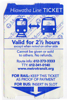
Passengers who ride the rail system are ordinarily charged the same fare as they would pay for the local Metro Transit bus system, and they are able to use their bus transfer cards to switch between the two different modes of transportation without making another payment. A new payment system using smart cards (known as Go-To Cards) was initially expected to be introduced along with the rail line in June 2004, but software bugs delayed introduction. By September 2006, the bugs were worked out and the Go-To Cards became operational.
In basic service, trains operate every 10 minutes, though rush hour sees one train every 7½ minutes, and late-night operation once every half hour. The line shuts down for about four hours each night, except for a shuttle service between the two terminals at the MSP airport. Vehicles have a capacity of 66 seated passengers and 120 standing. Currently two or three vehicles are linked together to increase capacity.
The line was originally named for Hiawatha Avenue, also known as Minnesota State Highway 55, which runs parallel to the train tracks for much of its distance. The line also runs for a few miles on the former Chicago, Milwaukee, St. Paul & Pacific Short Line roadbed which brought Hiawatha passenger trains into their downtown depot. To integrate the light rail route with the rest of the area bus system, it was also given the name Route 55. In extremely heavy travel periods and when the rail line is out of service for any reason, buses use that route number. Before the second phase had been completed, a temporary bus line known as Route 155 provided a link to some destinations south of the Fort Snelling station.
Significant effort has gone into creating artwork for the different rail stations. In the months after the line first started, a number of small audio and video playback devices were installed in the stations, to provide amusement and topics for discussion among travelers waiting for the train.
There are two stretches where tunnels are used on the line. A short tunnel parallel to Hiawatha Avenue travels under Minnehaha Parkway just north of the 50th Street station. At the airport, twin tunnels (one each for the northbound and southbound trains) go underground for 1.7 miles (2.7 km) to reach the Lindbergh Terminal station, the only stop that is totally underground—70 feet (21.3 m) below the surface. Trains return to the surface as they near Humphrey Terminal. Some of the sections under the airport required the use of a tunnel boring machine.
Vehicles

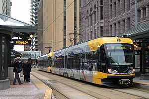
Currently the Blue Line uses 27 Flexity Swift trams manufactured by Bombardier, electrically powered by overhead lines. The system is designed to output 750 volts of direct current. Trains can reach speeds of 55 miles per hour (88.5 km/h), but the “general service speed” is about 40 mph (64.4 km/h) or slower (especially in the congested downtown region). They are of a 70% low-floor design, meaning that 70 percent of the floor inside is within about 14 inches (356 mm) of the ground. This is the same height as the rail platforms, allowing stepless access for passengers dependent on wheelchairs or other mobility aids. The feature also makes it easier for passengers with bicycles or strollers to board the train. Each vehicle weighs about 107,000 pounds (48,534 kg) when empty. The Minneapolis installation is the first use of this model in the United States.[9]
Vehicles have a color scheme that is primarily a combination of black, yellow, and gray. Yellow was used on the previous streetcar system in the area. Each vehicle has an A, B, and C section: The A and B sections are the large portions on each end, while the C section is a small portion that connects the two other pieces and has the vehicle's middle truck or bogie. Electricity is collected by a pantograph mounted on the B section. The first vehicle was delivered on March 19, 2003. 14 of 15 delivered vehicles were operational for the opening weekend. The initial order was eventually bumped up to a full 24 vehicles, which were operational by early 2005. Three additional vehicles were ordered in the winter of 2006/2007, using leftover funds from the construction budget for one vehicle and Hennepin County funds for the other two. This completes the first generation of rolling stock at a total of 27 vehicles on the line.
The noses of these vehicles are built to a different design than is standard for the Flexity Swift, containing a small scoop-shaped area. This could assist somewhat in the removal of snow, but the anticipated snow-management method is merely to run trains on a frequent basis rather than actually using snow removal equipment (this was what the earlier streetcar system usually did to keep lines clear, though they also often featured small scrapers in front of the lead wheels).
Each vehicle has a number of cameras on board, pointing both inward and outward, to monitor passenger activity and other areas of interest for security and safety. Train stations also have cameras. Video feeds and the position of each vehicle on the line are monitored in a control room at the system's maintenance facility, located between Cedar-Riverside and Franklin Avenue stations.
According to Metropolitan Council meeting notes dated July 30, 2010 for the August 9 Transportation Committee meeting, Siemens Industry Incorporated is expected to build the Light Rail Vehicles for the three-car train expansion project in a joint procurement with the Green Line's initial LRV procurement, at a per-LRV cost of $3,297,714 and a total contract value of $153,211,516.[10] According to Mark Fuhrmann's presentation at the July 26, 2010 Transportation Committee meeting, these "Type II" LRVs will be mechanically, but not electronically, compatible with the current fleet of 27 "type I" vehicles, so while the two generations will be able to run on the tracks at the same time and either type would be able to push a malfunctioning unit of the other type, multiple-unit trains may only be assembled of one type.[11]
History
The Minneapolis–St. Paul area once had an extensive network of streetcars (operated for many years by Twin City Rapid Transit, a precursor of Metro Transit), but the tracks were removed and services were eliminated in the 1950s.
Over the years since the last trolley ran in 1954, many people have pushed for the reintroduction of rail transport in the Twin Cities. The primary reason is that traffic congestion has grown considerably since the streetcar system ceased operation: a 2003 report by the Texas Transportation Institute indicated that the area was the 17th most congested area in the country, with the second fastest congestion growth. Congestion is also one of the most prominent complaints of area residents.[citation needed] The area's population is expected to grow by about one million residents by 2020, adding to the population of 3.3 million as of the 2010 census.[citation needed] This means that in less than 10 years the area could have a population of more than 4 million similar in size to the metropolitan area of Phoenix, AZ or Detroit, MI.
No new rail projects were able to get off the ground for many years until the 1990s when several factors combined to make the idea more palatable to area politicians. Governor Jesse Ventura and Minnesota Transportation Commissioner Elwyn Tinklenberg heavily promoted the idea of rail transport, and significant amounts of money became available from the federal government. Previous governors had advocated light rail, but had not been able to get legislation passed. Governor Tim Pawlenty had campaigned on a promise to fight the expansion of light rail, but altered his opinions after taking office. He also initially opposed the Northstar Line commuter rail project, which is a rail corridor north of Minneapolis, but changed his mind about that project in January 2004 when a scaled-back version was shown to have good potential.[12]

For many, the Hiawatha Avenue corridor was not the top choice for a new project. Popular other options included connecting Minneapolis with the western suburbs, though probably the most-desired option has been the Central Corridor connecting the Twin Cities themselves (Minneapolis and St. Paul) with a route down the middle of Interstate 94 or University Avenue. However, much of the land had already been acquired by the state in the 1960s in preparation for a sunken radial expressway into downtown that was never built. In addition to the available land, the desire to connect to the airport and at least reach the vicinity of the Mall of America proved to be the bigger draw for decision-makers.[13]
The idea of running a rail line down Hiawatha Avenue had already been around for at least a decade by the time the decision was made to go forward. In 1985, the Minnesota Department of Transportation (Mn/DOT) had produced an Environmental Impact Statement that concluded that light rail was the best alternative for the corridor.[14] In 1996, the document was examined again as Mn/DOT looked at the possibility of adding a busway (bus rapid transit) along the road, but money for light rail became available soon after, leading to the current layout.
Groundbreaking for the line took place on January 17, 2001. Regular service began on the first phase of the line on June 26, 2004, with the second phase opening later that year on December 4. Each opening was accompanied with two days of free rides on the train and area buses. The line was tested for months before opening, with regular service simulated for about a month before each phase went online. The Hiawatha Line opened 50 years and one week after the last regular-service streetcars ran in the city.
Busways are still being examined for many future projects, and it appears likely that at least one will be built. Construction of the area's second light rail line, the Green Line connecting downtown Minneapolis and St. Paul began in late 2010. On April 26, 2011, the U.S. government announced $478 million in funding for its construction.[15] In late 2011, plans for a third LRT, Southwest Corridor Line (Green Line extension) were approved and are awaiting funding.
Funding and delays
The line's cost totaled $715.3 million, with $334.3 million coming from the federal government.[16] This is considerably higher than initial budgets predicted—the figure was about $400 million in 1997. Opponents to the rail line state that it went far over-budget, but supporters of the line state that extensions of the route and other alterations, plus the impact of inflation, are the real reasons for the increased cost. Initial designs cut out the last stop in downtown, and the southern end of the line did not quite connect to the Mall of America. The Warehouse District stop was added early but another cost increase came from approximately $40 million to enhance the line (while construction was in progress) to bring the line directly into the Mall of America's transit hub. It was completed later than what was initially hoped for (a lot of literature points to 2003 as the opening year), but the mall connection was a significant contribution to the extra time requirements.[citation needed] These extensions are also why the line was initially reported to be 11.6 miles long, but ended up being 12 miles in length. The Target Field extension in 2009 added a few more tenths to the length.
In March 2004, the labor union representing Metro Transit bus workers went on strike. This delayed the opening of the line from the anticipated start date of April 3, although there was some indication that the opening would have been delayed anyway. Apparently, some of the delay had to do with slow delivery of trainsets from Bombardier. Certain aspects of the design had been tried before, but the cars were the first to combine the factors of conforming to American standards (as opposed to European), having low floors, and being built at the company's Mexico plant. Some problems also cropped up during testing of the vehicles, but Bombardier has said that the issues were not out of the ordinary.[citation needed]
When the buses began rolling again on April 19, the line's opening was rolled back to June 26. Testing of the track and vehicles continued during the bus strike, as much of the work was performed by Bombardier employees rather than Metro Transit workers. Train operators who had already gone through the training process were given refresher courses when the strike ended.
Proposed extension
An extension of the line to Maple Grove or Brooklyn Park is planned. An additional another nine stations could be added to the line if the extension is built.
Safety
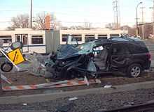
By January 2014 there had been ten deaths from accidents on the line, six of them pedestrians.[17]
With an impending line expansion, Metro Transit rolled out a new rail safety campaign, with representatives of Metro Transit customers visiting schools and organizations situated near the Blue Line to discuss rail safety.[18] The campaign won a visual design award from the Minnesota Association of Government Communicators.[19]
See also
References
- ↑ 1.0 1.1 "Ridership Report Archives". American Public Transportation Association. Retrieved January 14, 2014.
- ↑ "These routes will change May 18". Metro Transit. Retrieved May 3, 2013.
- ↑ "Minneapolis: More spectacular ridership gains for Hiawatha light rail transit". Light Rail Now. August 2008. Retrieved December 17, 2009.
- ↑ "Met Council approves line color names for region's developing transitway system". Metropolitan Council. July 2011. Retrieved August 31, 2011.
- ↑ "Hiawatha light-rail name to be phased out for Blue Line". StarTribune. May 17, 2013. Retrieved May 23, 2013.
- ↑ "Minneapolis Detail Map". Hennepin County (Southwest Corridor). Retrieved 2009-02-04.
- ↑ "Two New Stations in the Works for Hiawatha Line in Minneapolis". Mass Transit Magazine. Retrieved 2009-02-04.
- ↑ "Down the Line; Light Rail's First Day." Star Tribune; June 27, 2004
- ↑ "Bombardier FLEXITY Swift – Minneapolis/St. Paul, USA". Bombardier. Retrieved 2007-01-31.
- ↑ "Transportation Committee Business Item 2010-275". Metropolitan Council. 2010-07-30. Retrieved 2010-08-06.
- ↑ "Transportation Committee Meeting July 26, 2010". Metropolitan Council. 2010-07-26. Retrieved 2010-08-06.
- ↑ by Laura McCallum (August 3, 2004). "Pawlenty finds money to jumpstart North Star rail line". Minnesota Public Radio.
- ↑ Newberg, Sam (May 2004). "Light Rail Comes to Minnesota" (PDF). community-wealth.org. American Planning Association. Retrieved 3 December 2013.
- ↑ Collopy, Trisha (Summer 2004). "The Right Track". Inventing Tomorrow (University of Minnesota). Retrieved December 17, 2009.
- ↑ Van Denburg, Hart (April 2011). "Feds signing over $478 million in Central Corridor funding today". City Pages. Retrieved April 26, 2011.
- ↑ "Facts About Trains and Construction". Metro Transit. Retrieved December 29, 2012.
- ↑ Nelson, Tim (13 January 2014). "Minneapolis light rail train hits, kills pedestrian". Minnesota Public Radio. Retrieved 13 January 2014.
- ↑ Harlow, Tim (2013-09-13). "The Drive: Prohibited turns bring light-rail mishaps". The Star Tribune.
- ↑ Minnesota Association of Government Communicators (2013-05-20). "2013 Award Winners". Northern Lights Awards.
External links
- Metro Transit: METRO Blue Line
- nycsubway.org: Hiawatha Line image collection
- Route map and schedule
- Network map (to scale)
| |||||||||||||||||||||||||||||||||||||||||||||||||||||||||||||||||||||||||||||
| ||||||||||||||||||||||||||