Blackfriars, Greater Manchester
From Wikipedia, the free encyclopedia
Coordinates: 53°29′12″N 2°15′09″W / 53.4867°N 2.2524°W
| Blackfriars | |
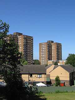
 Social housing in Blackfriars |
|
 Blackfriars | |
| OS grid reference | SJ832989 |
|---|---|
| Metropolitan borough | Salford |
| Metropolitan county | Greater Manchester |
| Region | North West |
| Country | England |
| Sovereign state | United Kingdom |
| Post town | SALFORD |
| Postcode district | M3 |
| Dialling code | 0161 |
| Police | Greater Manchester |
| Fire | Greater Manchester |
| Ambulance | North West |
| EU Parliament | North West England |
| Salford and Eccles | |
| |
Blackfriars is a small inner-city area and former ward of Salford, in Greater Manchester, England. It is situated along the banks of the River Irwell, close to the traditional centre of Salford at Greengate, between Manchester City Centre and Broughton. Blackfriars contains Blackfriars Park, one of Salford's smaller parks,[1] and is home to the Friars Primary School.[2]
Due to slum clearance very few buildings in Blackfriars now predate the 1960s. One notable exception is the 1871-built tavern[3] on Blackfriars Road, which has now been converted into homes for shared ownership.
References
| |||||
This article is issued from Wikipedia. The text is available under the Creative Commons Attribution/Share Alike; additional terms may apply for the media files.